Kimmins Topo Map Tennessee
To zoom in, hover over the map of Kimmins
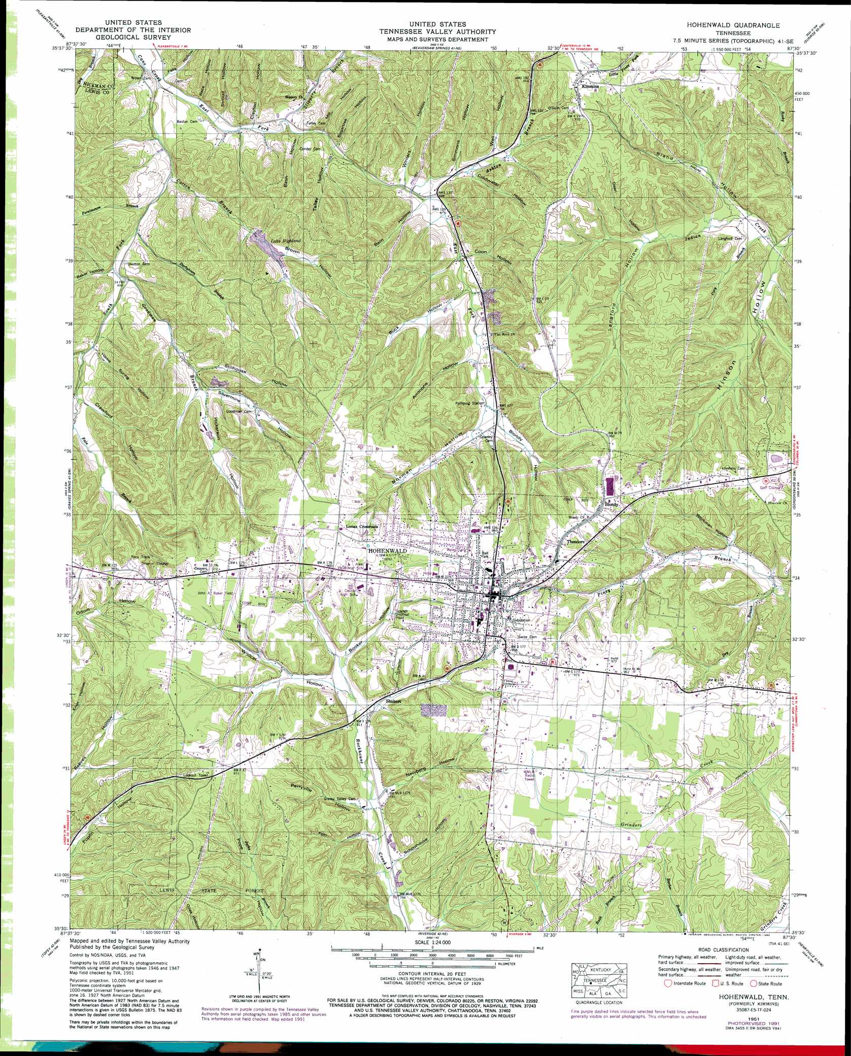
USGS Topo Quad 35087e5 - 1:24,000 scale
| Topo Map Name: | Kimmins |
| USGS Topo Quad ID: | 35087e5 |
| Print Size: | ca. 21 1/4" wide x 27" high |
| Southeast Coordinates: | 35.5° N latitude / 87.5° W longitude |
| Map Center Coordinates: | 35.5625° N latitude / 87.5625° W longitude |
| U.S. State: | TN |
| Filename: | o35087e5.jpg |
| Download Map JPG Image: | Kimmins topo map 1:24,000 scale |
| Map Type: | Topographic |
| Topo Series: | 7.5´ |
| Map Scale: | 1:24,000 |
| Source of Map Images: | United States Geological Survey (USGS) |
| Alternate Map Versions: |
Kimmins TN 1936 Download PDF Buy paper map Kimmins TN 1951, updated 1956 Download PDF Buy paper map Kimmins TN 1951, updated 1971 Download PDF Buy paper map Hohenwald TN 1951, updated 1992 Download PDF Buy paper map Hohenwald TN 2010 Download PDF Buy paper map Hohenwald TN 2013 Download PDF Buy paper map Hohenwald TN 2016 Download PDF Buy paper map |
1:24,000 Topo Quads surrounding Kimmins
Lobelville |
Coble |
Whitfield |
Centerville |
Littlelot |
Chestnut Grove |
Pleasantville |
Beaverdam Springs |
Sunrise |
Greenfield Bend |
Linden |
Graves Spring |
Kimmins |
Gordonsburg |
Mount Joy |
Leatherwood |
Topsy |
Riverside |
Henryville |
Summertown |
Waynesboro |
Negro Hollow |
Ovilla |
Deerfield |
Ethridge |
> Back to 35087e1 at 1:100,000 scale
> Back to 35086a1 at 1:250,000 scale
> Back to U.S. Topo Maps home
Kimmins topo map: Gazetteer
Kimmins: Airports
John A Baker Field elevation 293m 961′Kimmins: Dams
Highland Lake Dam elevation 233m 764′Kimmins: Forests
Lewis State Forest elevation 284m 931′Kimmins: Mines
Carters Prospect elevation 287m 941′Coble Prospect elevation 251m 823′
Goodmans Prong Prospect Number One elevation 260m 853′
Goodmans Prong Prospect Number Two elevation 283m 928′
Hughes Bank Prospect elevation 281m 921′
Long Bank Prospect elevation 264m 866′
Overby Prospect elevation 277m 908′
Skelton Prospect elevation 292m 958′
Smith Bank Number One Prospect elevation 272m 892′
Smith Bank Number Three Prospect elevation 276m 905′
Smith Bank Number Three Prospect elevation 278m 912′
Wapf Bank Prospect elevation 277m 908′
Kimmins: Populated Places
Blondy elevation 293m 961′Flat Rock (historical) elevation 223m 731′
Hohenwald elevation 298m 977′
Kimmins elevation 290m 951′
Lomax Crossroads elevation 292m 958′
Shubert elevation 253m 830′
Theodore elevation 293m 961′
Kimmins: Post Offices
Hohenwald Post Office elevation 297m 974′Kimmins Post Office elevation 290m 951′
Kimmins: Reservoirs
Highland Lake elevation 233m 764′Lake Highland elevation 218m 715′
Kimmins: Ridges
Peters Ridge elevation 262m 859′Kimmins: Springs
Crystal Spring elevation 231m 757′Downey Spring elevation 226m 741′
Kimmins: Streams
Ashton Branch elevation 200m 656′Cory Branch elevation 201m 659′
Cotton Branch elevation 188m 616′
Darbytown Branch elevation 190m 623′
Dry Branch elevation 218m 715′
East Fork Cane Creek elevation 183m 600′
Fain Branch elevation 215m 705′
Goodman Branch elevation 194m 636′
Persimmon Branch elevation 189m 620′
Slippery Branch elevation 189m 620′
South Fork Cane Creek elevation 182m 597′
Wildcat Branch elevation 251m 823′
Kimmins: Valleys
Ammons Hollow elevation 219m 718′Baker Hollow elevation 194m 636′
Barn Hollow elevation 208m 682′
Bash Hollow elevation 192m 629′
Bell Hollow elevation 226m 741′
Bland Hollow elevation 208m 682′
Blondy Hollow elevation 232m 761′
Booker Hollow elevation 255m 836′
Brown Hollow elevation 223m 731′
Buck Hollow elevation 213m 698′
Clayton Hollow elevation 192m 629′
Coldwater Hollow elevation 212m 695′
Coon Hollow elevation 211m 692′
Crawford Hollow elevation 213m 698′
Dean Hollow elevation 225m 738′
Fain Hollow elevation 234m 767′
Falls Hollow elevation 184m 603′
Hickerson Hollow elevation 216m 708′
Hinson Hollow elevation 198m 649′
Home Spring Hollow elevation 208m 682′
Langford Hollow elevation 221m 725′
Lee Hollow elevation 199m 652′
Mill Hollow elevation 202m 662′
Newberg Hollow elevation 238m 780′
Norman Hollow elevation 228m 748′
Perryville Hollow elevation 236m 774′
Race Hollow elevation 191m 626′
Schoolhouse Hollow elevation 241m 790′
Silvermine Hollow elevation 213m 698′
Simmons Hollow elevation 209m 685′
Stillhouse Hollow elevation 212m 695′
Stroud Hollow elevation 192m 629′
Sugartree Hollow elevation 198m 649′
Talley Hollow elevation 202m 662′
Turnbow Hollow elevation 204m 669′
Well Hollow elevation 221m 725′
Wildcat Hollow elevation 251m 823′
Winters Hollow elevation 202m 662′
Workman Hollow elevation 231m 757′
Kimmins digital topo map on disk
Buy this Kimmins topo map showing relief, roads, GPS coordinates and other geographical features, as a high-resolution digital map file on DVD: