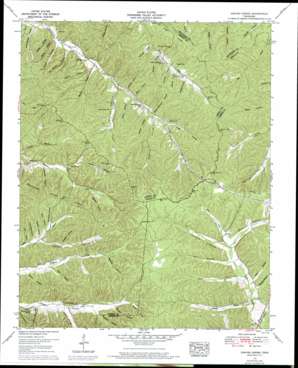
Graves Spring Topo Map Tennessee
To zoom in, hover over the map of Graves Spring
USGS Topo Quad 35087e6 - 1:24,000 scale
| Topo Map Name: | Graves Spring |
| USGS Topo Quad ID: | 35087e6 |
| Print Size: | ca. 21 1/4" wide x 27" high |
| Southeast Coordinates: | 35.5° N latitude / 87.625° W longitude |
| Map Center Coordinates: | 35.5625° N latitude / 87.6875° W longitude |
| U.S. State: | TN |
| Filename: | o35087e6.jpg |
| Download Map JPG Image: | Graves Spring topo map 1:24,000 scale |
| Map Type: | Topographic |
| Topo Series: | 7.5´ |
| Map Scale: | 1:24,000 |
| Source of Map Images: | United States Geological Survey (USGS) |
| Alternate Map Versions: |
Graves Spring TN 1936 Download PDF Buy paper map Graves Spring TN 1951, updated 1957 Download PDF Buy paper map Graves Spring TN 1951, updated 1970 Download PDF Buy paper map Graves Spring TN 1951, updated 1970 Download PDF Buy paper map Graves Spring TN 2010 Download PDF Buy paper map Graves Spring TN 2013 Download PDF Buy paper map Graves Spring TN 2016 Download PDF Buy paper map |
1:24,000 Topo Quads surrounding Graves Spring
> Back to 35087e1 at 1:100,000 scale
> Back to 35086a1 at 1:250,000 scale
> Back to U.S. Topo Maps home
Graves Spring topo map: Gazetteer
Graves Spring: Flats
Hickory Flat elevation 266m 872′Graves Spring: Lakes
Horse Pond elevation 289m 948′Graves Spring: Springs
Graves Spring elevation 209m 685′Graves Spring: Streams
Arkansas Branch elevation 216m 708′Carter Branch elevation 197m 646′
Edwards Branch elevation 174m 570′
Fall Branch elevation 192m 629′
Hugh Hollow Branch elevation 204m 669′
Moon Branch elevation 219m 718′
Graves Spring: Valleys
Apple Orchard Hollow elevation 200m 656′Barn Hollow elevation 209m 685′
Barn Hollow elevation 170m 557′
Bishop Hollow elevation 177m 580′
Bob Barber Hollow elevation 218m 715′
Boneyard Hollow elevation 213m 698′
Bowen Hollow elevation 213m 698′
Bryson Hollow elevation 212m 695′
Camper Hollow elevation 186m 610′
Cane Patch Hollow elevation 201m 659′
Carter Hollow elevation 197m 646′
Chestnut Hollow elevation 214m 702′
Chop Hollow elevation 192m 629′
Comer Hollow elevation 202m 662′
Dill Hollow elevation 230m 754′
Duncan Hollow elevation 235m 770′
Enoch Hollow elevation 164m 538′
Graves Hollow elevation 215m 705′
Hamm Hollow elevation 194m 636′
Hensley Hollow elevation 188m 616′
Hogpen Hollow elevation 227m 744′
Hugh Hollow elevation 201m 659′
Joe Barber Hollow elevation 169m 554′
Knot Hollow elevation 226m 741′
Morgan Hollow elevation 199m 652′
Mulberry Hollow elevation 213m 698′
Odom Hollow elevation 231m 757′
Oldfield Hollow elevation 220m 721′
Parsonage Hollow elevation 207m 679′
Patch Hollow elevation 198m 649′
Penny Hollow elevation 194m 636′
Poplin Hollow elevation 185m 606′
Poplin Hollow elevation 213m 698′
Qualls Hollow elevation 163m 534′
Reeves Hollow elevation 224m 734′
Roberts Hollow elevation 227m 744′
Sand Trace Hollow elevation 233m 764′
Sheep Hollow elevation 193m 633′
Sinkhole Hollow elevation 195m 639′
Slipoff Hollow elevation 243m 797′
Taylor Hollow elevation 172m 564′
Thomas Hollow elevation 225m 738′
Turnbow Hollow elevation 231m 757′
Waxtree Hollow elevation 199m 652′
Whit Hollow elevation 200m 656′
Willis Barber Hollow elevation 163m 534′
Graves Spring digital topo map on disk
Buy this Graves Spring topo map showing relief, roads, GPS coordinates and other geographical features, as a high-resolution digital map file on DVD:


