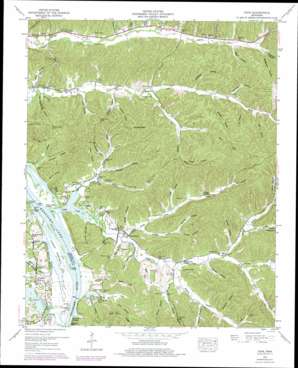
Pope Topo Map Tennessee
To zoom in, hover over the map of Pope
USGS Topo Quad 35087e8 - 1:24,000 scale
| Topo Map Name: | Pope |
| USGS Topo Quad ID: | 35087e8 |
| Print Size: | ca. 21 1/4" wide x 27" high |
| Southeast Coordinates: | 35.5° N latitude / 87.875° W longitude |
| Map Center Coordinates: | 35.5625° N latitude / 87.9375° W longitude |
| U.S. State: | TN |
| Filename: | o35087e8.jpg |
| Download Map JPG Image: | Pope topo map 1:24,000 scale |
| Map Type: | Topographic |
| Topo Series: | 7.5´ |
| Map Scale: | 1:24,000 |
| Source of Map Images: | United States Geological Survey (USGS) |
| Alternate Map Versions: |
Pope TN 1936 Download PDF Buy paper map Pope TN 1949, updated 1952 Download PDF Buy paper map Pope TN 1949, updated 1975 Download PDF Buy paper map Pope TN 2010 Download PDF Buy paper map Pope TN 2013 Download PDF Buy paper map Pope TN 2016 Download PDF Buy paper map |
1:24,000 Topo Quads surrounding Pope
> Back to 35087e1 at 1:100,000 scale
> Back to 35086a1 at 1:250,000 scale
> Back to U.S. Topo Maps home
Pope topo map: Gazetteer
Pope: Airports
Perry County Airport elevation 224m 734′Pope: Basins
Gumdale Dewatering Area elevation 111m 364′Pope: Crossings
New Era Ferry (historical) elevation 109m 357′Pope: Flats
Halabough Bottom elevation 113m 370′Pope: Islands
Kellys Island elevation 110m 360′Pope: Populated Places
Brownsport (historical) elevation 117m 383′Gumdale elevation 125m 410′
Horner elevation 129m 423′
New Era (historical) elevation 152m 498′
Pope elevation 120m 393′
Pope: Springs
Cave Spring elevation 123m 403′Fluty Spring elevation 166m 544′
Groom Spring elevation 157m 515′
Mayberry Spring elevation 137m 449′
Pope: Streams
Bateman Slough elevation 109m 357′Bee Creek elevation 109m 357′
Buck Fork elevation 128m 419′
Cedar Creek elevation 109m 357′
Cedar Creek elevation 109m 357′
Cow Branch elevation 110m 360′
DePriest Branch elevation 142m 465′
DePriest Branch elevation 143m 469′
Flowers Branch elevation 131m 429′
Fluty Branch elevation 134m 439′
Furnace Branch elevation 109m 357′
Goose Branch elevation 113m 370′
Halabough Branch elevation 115m 377′
Holder Branch elevation 115m 377′
Howell Branch elevation 127m 416′
Mayberry Branch elevation 120m 393′
McCurtie Branch elevation 115m 377′
Opossum Branch elevation 116m 380′
Persimmon Branch elevation 109m 357′
Scroggins Branch elevation 127m 416′
Slash Branch elevation 166m 544′
Smith Branch elevation 125m 410′
Swindle Creek elevation 113m 370′
Whites Creek elevation 109m 357′
Whitwell Branch elevation 115m 377′
Woods Branch elevation 127m 416′
Pope: Summits
Horses Head elevation 211m 692′Ward Hill elevation 219m 718′
Pope: Valleys
Alex Hollow elevation 160m 524′Allen Hollow elevation 114m 374′
Amos Hollow elevation 117m 383′
Ayers Hollow elevation 144m 472′
Barber Hollow elevation 147m 482′
Bridges Hollow elevation 150m 492′
Brooks Hollow elevation 117m 383′
Bunch Hollow elevation 138m 452′
Caleb Hollow elevation 113m 370′
Cow Hollow elevation 113m 370′
Craig Hollow elevation 129m 423′
Cris Hollow elevation 123m 403′
Cross Hollow elevation 146m 479′
Denton Hollow elevation 131m 429′
DePriest Hollow elevation 142m 465′
Duncan Hollow elevation 113m 370′
Furnace Hollow elevation 109m 357′
Ghents Hollow elevation 112m 367′
Grapevine Hollow elevation 170m 557′
Gurley Hollow elevation 114m 374′
Hall Deadening Hollow elevation 109m 357′
Harder Hollow elevation 115m 377′
Henson Hollow elevation 128m 419′
Horner Hollow elevation 143m 469′
Horner Hollow elevation 137m 449′
Inman Hollow elevation 160m 524′
Ivy Hollow elevation 158m 518′
Marvin Hollow elevation 139m 456′
Mayberry Hollow elevation 119m 390′
McGee Hollow elevation 124m 406′
Orebank Hollow elevation 133m 436′
Reed Hollow elevation 160m 524′
Shipman Hollow elevation 142m 465′
Slickrock Hollow elevation 166m 544′
Smith Hollow elevation 116m 380′
Sutton Hollow elevation 135m 442′
Tarwater Hollow elevation 154m 505′
Thompson Hollow elevation 124m 406′
Tracey Hollow elevation 116m 380′
Turner Hollow elevation 124m 406′
Turner Hollow elevation 133m 436′
Woods Hollow elevation 151m 495′
Wright Hollow elevation 138m 452′
Pope digital topo map on disk
Buy this Pope topo map showing relief, roads, GPS coordinates and other geographical features, as a high-resolution digital map file on DVD:


