Beaverdam Springs Topo Map Tennessee
To zoom in, hover over the map of Beaverdam Springs
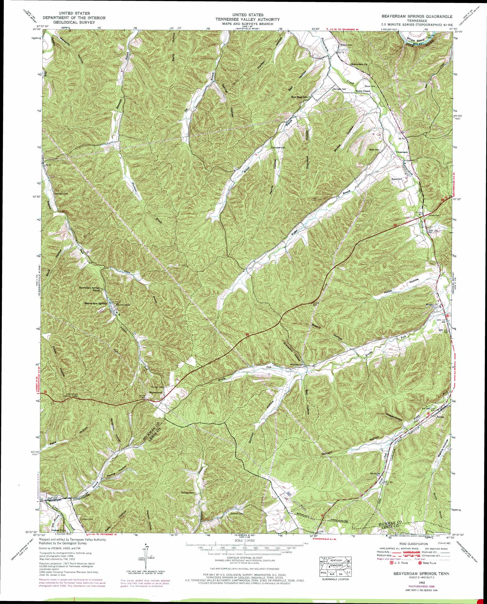
USGS Topo Quad 35087f5 - 1:24,000 scale
| Topo Map Name: | Beaverdam Springs |
| USGS Topo Quad ID: | 35087f5 |
| Print Size: | ca. 21 1/4" wide x 27" high |
| Southeast Coordinates: | 35.625° N latitude / 87.5° W longitude |
| Map Center Coordinates: | 35.6875° N latitude / 87.5625° W longitude |
| U.S. State: | TN |
| Filename: | o35087f5.jpg |
| Download Map JPG Image: | Beaverdam Springs topo map 1:24,000 scale |
| Map Type: | Topographic |
| Topo Series: | 7.5´ |
| Map Scale: | 1:24,000 |
| Source of Map Images: | United States Geological Survey (USGS) |
| Alternate Map Versions: |
Beaverdam Springs TN 1936 Download PDF Buy paper map Beaverdam Springs TN 1952, updated 1957 Download PDF Buy paper map Beaverdam Springs TN 1952, updated 1970 Download PDF Buy paper map Beaverdam Springs TN 2010 Download PDF Buy paper map Beaverdam Springs TN 2013 Download PDF Buy paper map Beaverdam Springs TN 2016 Download PDF Buy paper map |
1:24,000 Topo Quads surrounding Beaverdam Springs
Hurricane Mills |
Bucksnort |
Spot |
Texas Hollow |
Lyles |
Lobelville |
Coble |
Whitfield |
Centerville |
Littlelot |
Chestnut Grove |
Pleasantville |
Beaverdam Springs |
Sunrise |
Greenfield Bend |
Linden |
Graves Spring |
Kimmins |
Gordonsburg |
Mount Joy |
Leatherwood |
Topsy |
Riverside |
Henryville |
Summertown |
> Back to 35087e1 at 1:100,000 scale
> Back to 35086a1 at 1:250,000 scale
> Back to U.S. Topo Maps home
Beaverdam Springs topo map: Gazetteer
Beaverdam Springs: Mines
Aetna Mine elevation 264m 866′Jenkins Hollow Prospects elevation 248m 813′
Nicholson Prospects elevation 277m 908′
Piney Fork Prospects elevation 253m 830′
Washer Hollow Tunnel Mine elevation 265m 869′
West Black Hollow Mine elevation 258m 846′
Beaverdam Springs: Populated Places
Aetna elevation 213m 698′Beaverdam Springs elevation 199m 652′
Crossroads elevation 175m 574′
Hornertown elevation 286m 938′
Beaverdam Springs: Springs
Beaverdam Springs elevation 198m 649′Beaverdam Springs: Streams
Bear Creek elevation 140m 459′Brushy Fork elevation 189m 620′
DePriest Branch elevation 176m 577′
Dry Branch elevation 177m 580′
Little Piney Fork elevation 221m 725′
Milam Branch elevation 163m 534′
Peters Branch elevation 184m 603′
Piney Fork elevation 189m 620′
Wades Branch elevation 173m 567′
Beaverdam Springs: Valleys
Bell Hollow elevation 167m 547′Bell Hollow elevation 219m 718′
Breece Hollow elevation 211m 692′
Carter Hollow elevation 182m 597′
Duncan Hollow elevation 220m 721′
Goodman Hollow elevation 207m 679′
Graveyard Hollow elevation 220m 721′
Harber Hollow elevation 163m 534′
Harris Hollow elevation 185m 606′
Hicks Hollow elevation 188m 616′
Johnson Hollow elevation 218m 715′
Malugin Hollow elevation 223m 731′
Meredith Hollow elevation 151m 495′
Prince Hollow elevation 171m 561′
Skull Hollow elevation 182m 597′
Spring Hollow elevation 171m 561′
Spring Hollow elevation 198m 649′
Staggs Hollow elevation 225m 738′
Thornton Hollow elevation 180m 590′
Beaverdam Springs digital topo map on disk
Buy this Beaverdam Springs topo map showing relief, roads, GPS coordinates and other geographical features, as a high-resolution digital map file on DVD: