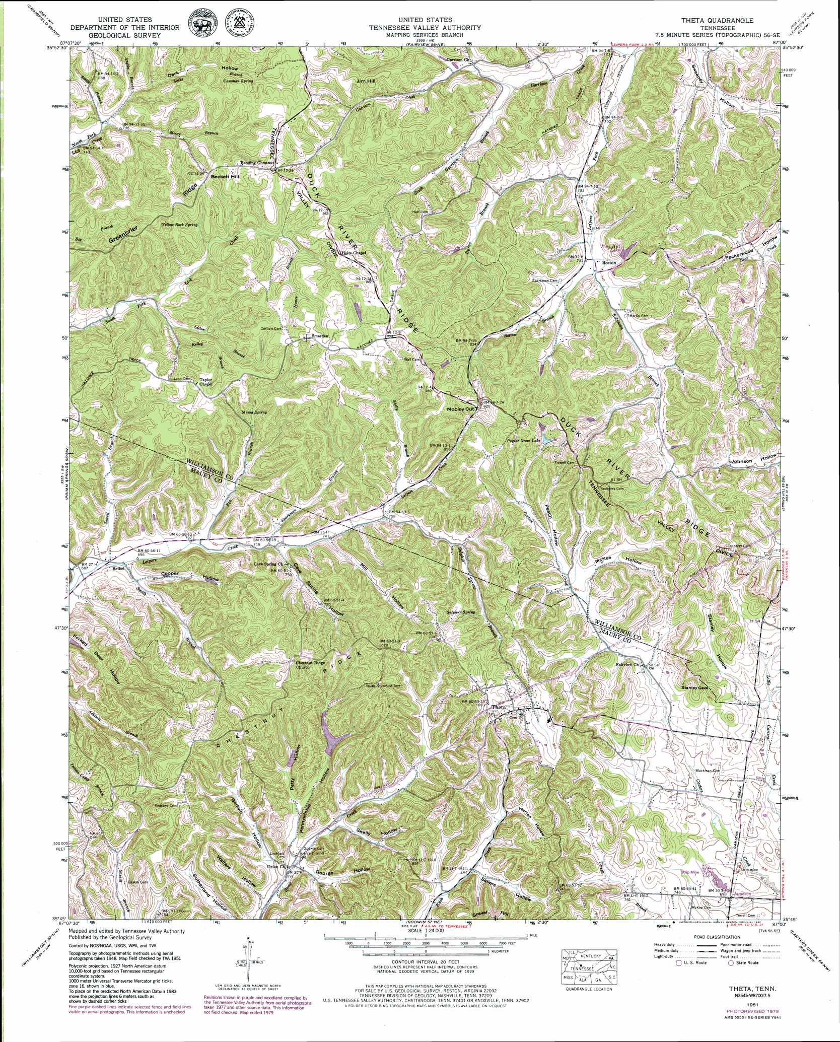
Theta Topo Map Tennessee
To zoom in, hover over the map of Theta
USGS Topo Quad 35087g1 - 1:24,000 scale
| Topo Map Name: | Theta |
| USGS Topo Quad ID: | 35087g1 |
| Print Size: | ca. 21 1/4" wide x 27" high |
| Southeast Coordinates: | 35.75° N latitude / 87° W longitude |
| Map Center Coordinates: | 35.8125° N latitude / 87.0625° W longitude |
| U.S. State: | TN |
| Filename: | o35087g1.jpg |
| Download Map JPG Image: | Theta topo map 1:24,000 scale |
| Map Type: | Topographic |
| Topo Series: | 7.5´ |
| Map Scale: | 1:24,000 |
| Source of Map Images: | United States Geological Survey (USGS) |
| Alternate Map Versions: |
Theta TN 1936 Download PDF Buy paper map Theta TN 1951, updated 1957 Download PDF Buy paper map Theta TN 1951, updated 1975 Download PDF Buy paper map Theta TN 1951, updated 1980 Download PDF Buy paper map Theta TN 1951, updated 1984 Download PDF Buy paper map Theta TN 2010 Download PDF Buy paper map Theta TN 2013 Download PDF Buy paper map Theta TN 2016 Download PDF Buy paper map |
1:24,000 Topo Quads surrounding Theta
Burns |
White Bluff |
Kingston Springs |
Bellevue |
Oak Hill |
Lyles |
Craigfield |
Fairview |
Leipers Fork |
Franklin |
Littlelot |
Primm Springs |
Theta |
Spring Hill |
Bethesda |
Greenfield Bend |
Williamsport |
Godwin |
Carters Creek |
Rally Hill |
Mount Joy |
Mount Pleasant |
Columbia |
Glendale |
Verona |
> Back to 35087e1 at 1:100,000 scale
> Back to 35086a1 at 1:250,000 scale
> Back to U.S. Topo Maps home
Theta topo map: Gazetteer
Theta: Dams
Lost Acres Dam elevation 233m 764′McCall Lake Dam elevation 261m 856′
Pine Hill Dam elevation 236m 774′
Poplar Grove Dam Number One elevation 267m 875′
Theta: Gaps
Mobley Cut elevation 274m 898′Theta: Mines
Hatcher Mine elevation 212m 695′Theta: Populated Places
Bethel elevation 211m 692′Boston elevation 222m 728′
Jameson elevation 211m 692′
Loco (historical) elevation 217m 711′
Smarden elevation 312m 1023′
Sulphur Springs (historical) elevation 256m 839′
Theta elevation 306m 1003′
Theta: Reservoirs
Lost Acres Lake elevation 233m 764′McCall Lake elevation 261m 856′
Pine Hill Lake elevation 236m 774′
Poplar Grove Lake elevation 267m 875′
Theta: Ridges
Chestnut Ridge elevation 290m 951′Cunningham Ridge elevation 272m 892′
Greenbrier Ridge elevation 290m 951′
Theta: Springs
Cassman Spring elevation 261m 856′Cave Springs elevation 232m 761′
Mossy Spring elevation 256m 839′
Sulphur Spring elevation 269m 882′
Yellow Rock Spring elevation 255m 836′
Theta: Streams
Anglin Branch elevation 231m 757′Boston Branch elevation 221m 725′
Burns Branch elevation 216m 708′
Fox Branch elevation 213m 698′
Garrison Creek elevation 207m 679′
Kelley Branch elevation 225m 738′
Litton Branch elevation 230m 754′
Locke Branch elevation 231m 757′
Moore Branch elevation 222m 728′
Nance Branch elevation 256m 839′
Pettys Branch elevation 213m 698′
Robinson Branch elevation 221m 725′
Sewell Branch elevation 211m 692′
Skelly Branch elevation 237m 777′
Smith Branch elevation 212m 695′
Smith Branch elevation 222m 728′
South Garrison Branch elevation 217m 711′
Sparkman Branch elevation 219m 718′
Sulphur Spring Branch elevation 230m 754′
Theta: Summits
Beckett Hill elevation 293m 961′Gravel Hill elevation 304m 997′
Jim Hill elevation 280m 918′
Theta: Valleys
Cave Spring Hollow elevation 220m 721′Cooper Hollow elevation 218m 715′
Dark Hollow elevation 225m 738′
George Hollow elevation 215m 705′
Godwin Hollow elevation 214m 702′
John Hunter Hollow elevation 214m 702′
McKee Hollow elevation 235m 770′
Mill Hollow elevation 224m 734′
Peach Hollow elevation 236m 774′
Pennywinkle Hollow elevation 212m 695′
Petty Hollow elevation 223m 731′
Sellers Hollow elevation 230m 754′
Skelly Hollow elevation 219m 718′
Stanley Hollow elevation 225m 738′
Sulphur Spring Hollow elevation 216m 708′
Walters Hollow elevation 214m 702′
Warren Hollow elevation 238m 780′
Theta digital topo map on disk
Buy this Theta topo map showing relief, roads, GPS coordinates and other geographical features, as a high-resolution digital map file on DVD: