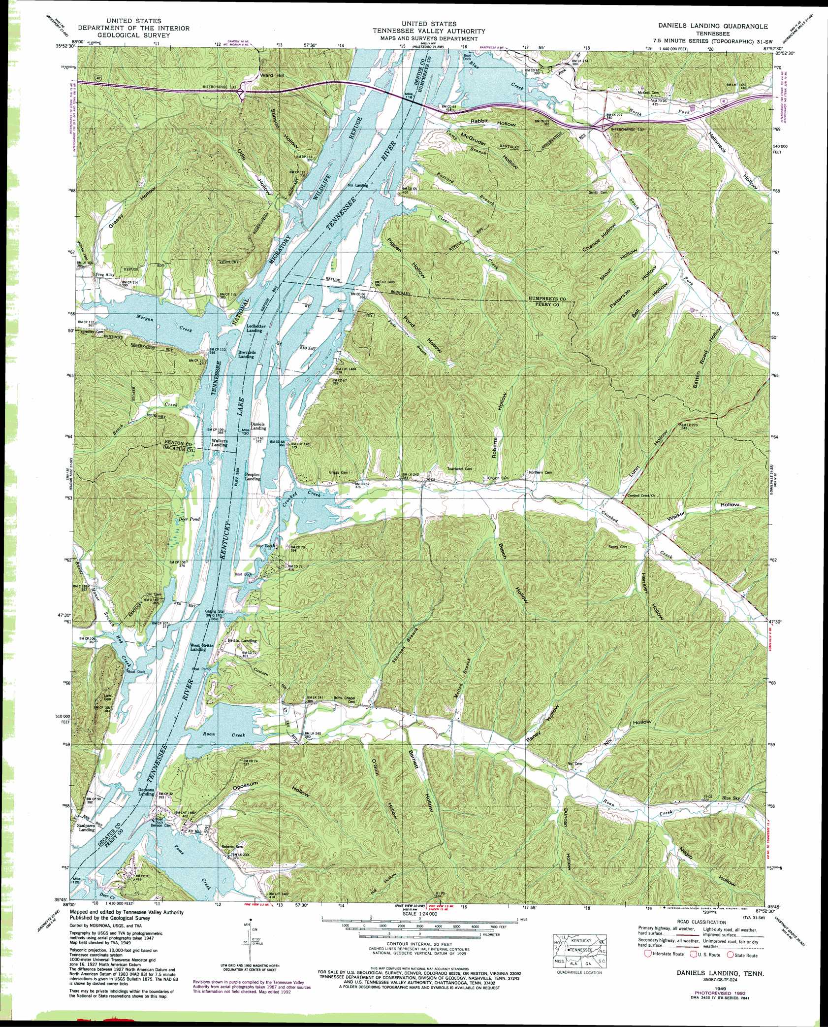
Daniels Landing Topo Map Tennessee
To zoom in, hover over the map of Daniels Landing
USGS Topo Quad 35087g8 - 1:24,000 scale
| Topo Map Name: | Daniels Landing |
| USGS Topo Quad ID: | 35087g8 |
| Print Size: | ca. 21 1/4" wide x 27" high |
| Southeast Coordinates: | 35.75° N latitude / 87.875° W longitude |
| Map Center Coordinates: | 35.8125° N latitude / 87.9375° W longitude |
| U.S. State: | TN |
| Filename: | o35087g8.jpg |
| Download Map JPG Image: | Daniels Landing topo map 1:24,000 scale |
| Map Type: | Topographic |
| Topo Series: | 7.5´ |
| Map Scale: | 1:24,000 |
| Source of Map Images: | United States Geological Survey (USGS) |
| Alternate Map Versions: |
Daniels Landing TN 1936 Download PDF Buy paper map Daniels Landing TN 1949, updated 1953 Download PDF Buy paper map Daniels Landing TN 1949, updated 1988 Download PDF Buy paper map Daniels Landing TN 1949, updated 1992 Download PDF Buy paper map Daniels Landing TN 2010 Download PDF Buy paper map Daniels Landing TN 2013 Download PDF Buy paper map Daniels Landing TN 2016 Download PDF Buy paper map |
1:24,000 Topo Quads surrounding Daniels Landing
Bruceton |
Camden |
Johnsonville |
Waverly |
Mcewen |
Seventeen Creek |
Rockport |
Hustburg |
Hurricane Mills |
Bucksnort |
Holladay |
Sugar Tree |
Daniels Landing |
Lobelville |
Coble |
Parsons |
Jeanette |
Pine View |
Chestnut Grove |
Pleasantville |
Scotts Hill |
Perryville |
Pope |
Linden |
Graves Spring |
> Back to 35087e1 at 1:100,000 scale
> Back to 35086a1 at 1:250,000 scale
> Back to U.S. Topo Maps home
Daniels Landing topo map: Gazetteer
Daniels Landing: Crossings
Interchange 133 elevation 203m 666′Interchange 137 elevation 116m 380′
Walkers Landing Ferry (historical) elevation 109m 357′
Daniels Landing: Guts
Pond Gut elevation 109m 357′Daniels Landing: Lakes
Deer Pond elevation 110m 360′Daniels Landing: Populated Places
Blue Sky elevation 156m 511′Cotham (historical) elevation 114m 374′
Crooked Creek elevation 134m 439′
Toms Creek (historical) elevation 132m 433′
Daniels Landing: Streams
Beach Creek elevation 109m 357′Beat Creek elevation 109m 357′
Burnt Honor Branch elevation 109m 357′
Buzzard Branch elevation 109m 357′
Camp Branch elevation 109m 357′
Clear Creek elevation 109m 357′
Crooked Creek elevation 109m 357′
Deer Creek elevation 109m 357′
Dog Creek elevation 109m 357′
Fools Branch elevation 109m 357′
Hog Creek elevation 109m 357′
Jack Branch elevation 109m 357′
Melton Branch elevation 122m 400′
Morgan Creek elevation 109m 357′
North Duncan Branch elevation 133m 436′
North Fork Blue Creek elevation 110m 360′
Raney Branch elevation 127m 416′
Roan Creek elevation 109m 357′
Roberts Creek elevation 109m 357′
Shannon Branch elevation 114m 374′
South Duncan Branch elevation 129m 423′
South Fork Blue Creek elevation 109m 357′
Toms Creek elevation 109m 357′
Daniels Landing: Summits
Cotham Hill elevation 155m 508′Cotham Hill elevation 152m 498′
Ward Hill elevation 203m 666′
Daniels Landing: Valleys
Barnett Hollow elevation 123m 403′Batten Road Hollow elevation 136m 446′
Beech Hollow elevation 121m 396′
Bell Hollow elevation 133m 436′
Chance Hollow elevation 140m 459′
Chance Hollow elevation 121m 396′
Duncan Hollow elevation 135m 442′
Grassy Hollow elevation 115m 377′
Hellsneck Hollow elevation 120m 393′
Hensley Hollow elevation 134m 439′
Lunn Hollow elevation 134m 439′
McGruder Hollow elevation 110m 360′
Negro Hollow elevation 143m 469′
Nix Hollow elevation 134m 439′
Odle Hollow elevation 110m 360′
O'Guin Hollow elevation 125m 410′
Opossum Hollow elevation 110m 360′
Patterson Hollow elevation 128m 419′
Pigpen Hollow elevation 111m 364′
Pond Hollow elevation 113m 370′
Rabbit Hollow elevation 114m 374′
Raney Hollow elevation 129m 423′
Roberts Hollow elevation 121m 396′
Stinson Hollow elevation 111m 364′
Stout Hollow elevation 126m 413′
Walker Hollow elevation 135m 442′
White Hollow elevation 116m 380′
Daniels Landing digital topo map on disk
Buy this Daniels Landing topo map showing relief, roads, GPS coordinates and other geographical features, as a high-resolution digital map file on DVD: