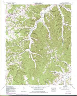
Fairview Topo Map Tennessee
To zoom in, hover over the map of Fairview
USGS Topo Quad 35087h1 - 1:24,000 scale
| Topo Map Name: | Fairview |
| USGS Topo Quad ID: | 35087h1 |
| Print Size: | ca. 21 1/4" wide x 27" high |
| Southeast Coordinates: | 35.875° N latitude / 87° W longitude |
| Map Center Coordinates: | 35.9375° N latitude / 87.0625° W longitude |
| U.S. State: | TN |
| Filename: | o35087h1.jpg |
| Download Map JPG Image: | Fairview topo map 1:24,000 scale |
| Map Type: | Topographic |
| Topo Series: | 7.5´ |
| Map Scale: | 1:24,000 |
| Source of Map Images: | United States Geological Survey (USGS) |
| Alternate Map Versions: |
Fairview TN 1951, updated 1957 Download PDF Buy paper map Fairview TN 1951, updated 1970 Download PDF Buy paper map Fairview TN 1951, updated 1980 Download PDF Buy paper map Fairview TN 1951, updated 1980 Download PDF Buy paper map Fairview TN 2010 Download PDF Buy paper map Fairview TN 2013 Download PDF Buy paper map Fairview TN 2016 Download PDF Buy paper map |
1:24,000 Topo Quads surrounding Fairview
> Back to 35087e1 at 1:100,000 scale
> Back to 35086a1 at 1:250,000 scale
> Back to U.S. Topo Maps home
Fairview topo map: Gazetteer
Fairview: Basins
Twomey Hole elevation 213m 698′Fairview: Cliffs
Buzzard Bluff elevation 222m 728′Cedar Bluff elevation 267m 875′
Lovers Leap elevation 177m 580′
Mill Bluff elevation 241m 790′
Otter Bluff elevation 219m 718′
Fairview: Dams
Fernvale Dam elevation 223m 731′Rotary Club Dam elevation 236m 774′
Fairview: Populated Places
Chester Estates elevation 237m 777′Fairview elevation 251m 823′
Fernvale elevation 189m 620′
Fernvale Springs (historical) elevation 183m 600′
Grammer Estates elevation 250m 820′
Kingfield elevation 284m 931′
Lakeview Estates elevation 259m 849′
Lone Oak elevation 263m 862′
Oak Tree elevation 256m 839′
Rolling Acres elevation 252m 826′
Fairview: Reservoirs
Fernvale Lake elevation 223m 731′Stephens Lake elevation 236m 774′
Fairview: Ridges
Crane Neck Ridge elevation 254m 833′Tom Redford Ridge elevation 285m 935′
Fairview: Springs
Basin Spring elevation 200m 656′Blowing Spring elevation 236m 774′
Copperas Spring elevation 268m 879′
Horntavern Spring elevation 225m 738′
Mayfield Spring elevation 184m 603′
Fairview: Streams
Allen Branch elevation 183m 600′Arkansas Creek elevation 191m 626′
Bedford Creek elevation 180m 590′
Blowing Spring Branch elevation 223m 731′
Caney Fork Creek elevation 192m 629′
Coldwater Branch elevation 213m 698′
Coleman Branch elevation 218m 715′
Copperas Branch elevation 212m 695′
Harpendene Branch elevation 194m 636′
Hunting Camp Creek elevation 183m 600′
Inman Branch elevation 204m 669′
Inman Branch elevation 191m 626′
Kelley Creek elevation 195m 639′
Little East Fork elevation 178m 583′
Pinewood Branch elevation 207m 679′
South Harpeth Creek elevation 189m 620′
Stovall Branch elevation 189m 620′
Twomey Hole Branch elevation 207m 679′
White Oak Branch elevation 219m 718′
Wilkie Branch elevation 201m 659′
Fairview: Summits
Flagpole Hill elevation 305m 1000′Fairview: Valleys
Bear Hollow elevation 207m 679′Big Ivey Hollow elevation 194m 636′
Black Sulphur Hollow elevation 183m 600′
Booger Hollow elevation 224m 734′
Childress Hollow elevation 183m 600′
Fish Pond Hollow elevation 189m 620′
Forhand Hollow elevation 198m 649′
Graveyard Hollow elevation 189m 620′
Greens Hollow elevation 226m 741′
Hargrove Hollow elevation 196m 643′
Ike Ivey Hollow elevation 178m 583′
Inman Hollow elevation 189m 620′
Mangrum Hollow elevation 213m 698′
McCrutchen Hollow elevation 186m 610′
McPherson Hollow elevation 189m 620′
Mill Hollow elevation 183m 600′
Peach Orchard Hollow elevation 207m 679′
Redford Hollow elevation 207m 679′
Reese Hollow elevation 194m 636′
Roberts Hollow elevation 213m 698′
Shelton Hollow elevation 201m 659′
Slat Fence Hollow elevation 202m 662′
Sleepy Hollow elevation 188m 616′
Slick Rock Hollow elevation 214m 702′
Sugar Camp Hollow elevation 182m 597′
Susan Hollow elevation 201m 659′
Sweeney Hollow elevation 205m 672′
Tally Hollow elevation 180m 590′
Tobacco Patch Hollow elevation 178m 583′
Tom Smith Hollow elevation 180m 590′
York Hollow elevation 197m 646′
Fairview digital topo map on disk
Buy this Fairview topo map showing relief, roads, GPS coordinates and other geographical features, as a high-resolution digital map file on DVD:


