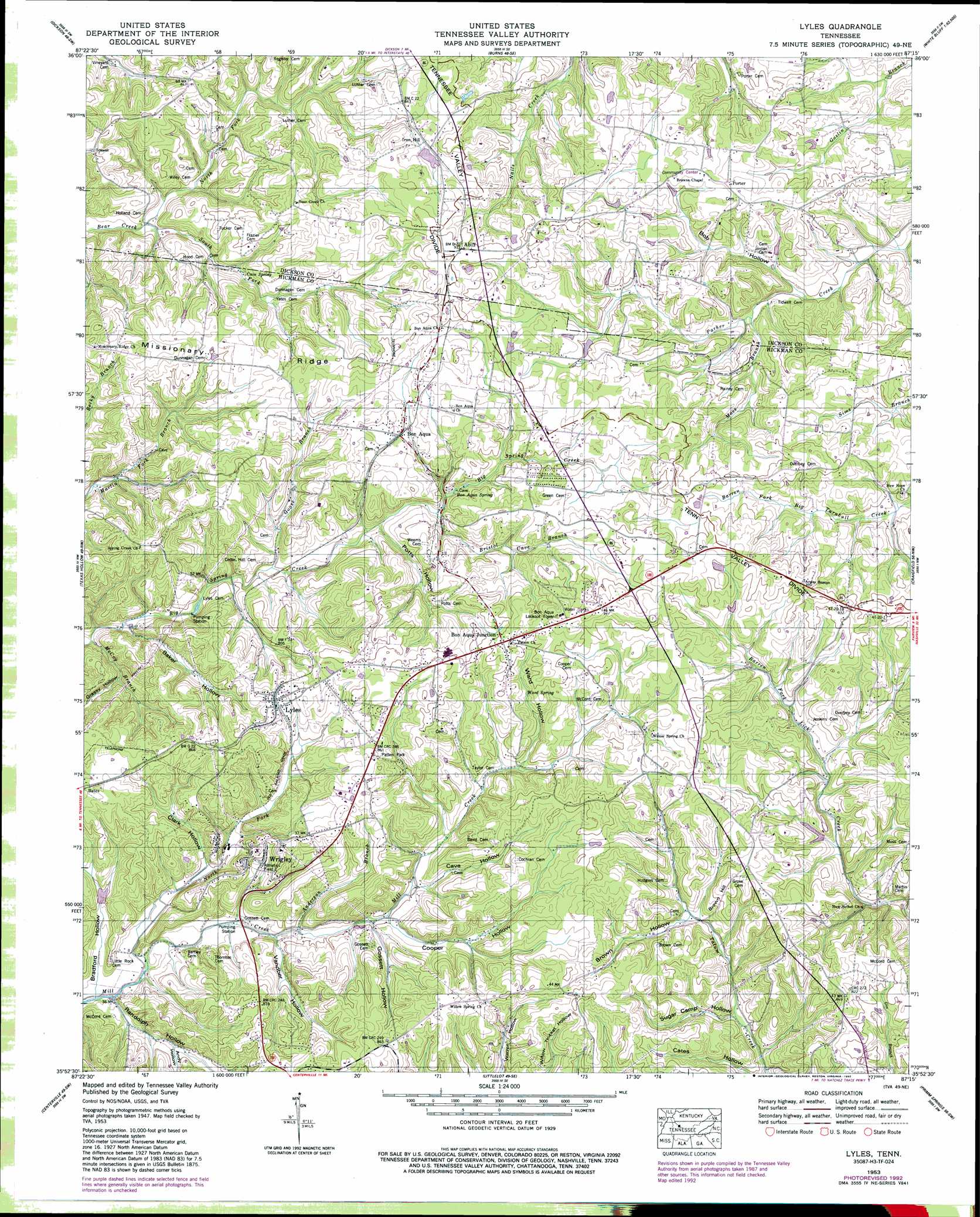
Lyles Topo Map Tennessee
To zoom in, hover over the map of Lyles
USGS Topo Quad 35087h3 - 1:24,000 scale
| Topo Map Name: | Lyles |
| USGS Topo Quad ID: | 35087h3 |
| Print Size: | ca. 21 1/4" wide x 27" high |
| Southeast Coordinates: | 35.875° N latitude / 87.25° W longitude |
| Map Center Coordinates: | 35.9375° N latitude / 87.3125° W longitude |
| U.S. State: | TN |
| Filename: | o35087h3.jpg |
| Download Map JPG Image: | Lyles topo map 1:24,000 scale |
| Map Type: | Topographic |
| Topo Series: | 7.5´ |
| Map Scale: | 1:24,000 |
| Source of Map Images: | United States Geological Survey (USGS) |
| Alternate Map Versions: |
Lyles TN 1936 Download PDF Buy paper map Lyles TN 1953, updated 1957 Download PDF Buy paper map Lyles TN 1953, updated 1971 Download PDF Buy paper map Lyles TN 1953, updated 1992 Download PDF Buy paper map Lyles TN 2010 Download PDF Buy paper map Lyles TN 2013 Download PDF Buy paper map Lyles TN 2016 Download PDF Buy paper map |
1:24,000 Topo Quads surrounding Lyles
Ruskin |
Vanleer |
Charlotte |
Harpeth Valley |
Lillamay |
Tennessee City |
Dickson |
Burns |
White Bluff |
Kingston Springs |
Spot |
Texas Hollow |
Lyles |
Craigfield |
Fairview |
Whitfield |
Centerville |
Littlelot |
Primm Springs |
Theta |
Beaverdam Springs |
Sunrise |
Greenfield Bend |
Williamsport |
Godwin |
> Back to 35087e1 at 1:100,000 scale
> Back to 35086a1 at 1:250,000 scale
> Back to U.S. Topo Maps home
Lyles topo map: Gazetteer
Lyles: Dams
Cedar Crest Camp Lake Dam elevation 234m 767′Lyles: Mines
Baker Hollow Prospect elevation 255m 836′Iron Hill Mine elevation 263m 862′
Lyles Mine elevation 266m 872′
Lyles Prospect elevation 286m 938′
Wrigley Prospect elevation 243m 797′
Lyles: Parks
Patten Park elevation 262m 859′Lyles: Populated Places
Abiff elevation 280m 918′Bates elevation 258m 846′
Bon Aqua elevation 254m 833′
Bon Aqua Junction elevation 275m 902′
Grove elevation 259m 849′
Iron Hill elevation 257m 843′
Lyles elevation 264m 866′
Mill Creek elevation 190m 623′
Porter elevation 257m 843′
Wrigley elevation 239m 784′
Lyles: Post Offices
Lyles Post Office elevation 267m 875′Lyles: Reservoirs
Cedar Crest Camp Lake elevation 234m 767′Lyles: Springs
Bon Aqua Springs elevation 243m 797′Cave Spring elevation 229m 751′
Ward Spring elevation 259m 849′
Lyles: Streams
Anderson Branch elevation 202m 662′Bristol Cave Branch elevation 224m 734′
Frith Spring Branch elevation 215m 705′
Goose Branch elevation 209m 685′
McCoy Branch elevation 193m 633′
Moss Branch elevation 220m 721′
North Fork Bear Creek elevation 203m 666′
North Fork Mill Creek elevation 192m 629′
South Fork Bear Creek elevation 201m 659′
Lyles: Summits
Brown Hill elevation 256m 839′Lyles: Valleys
Andy Hollow elevation 202m 662′Baker Hollow elevation 208m 682′
Bob Hollow elevation 213m 698′
Bradford Hollow elevation 193m 633′
Brown Hollow elevation 217m 711′
Cave Hollow elevation 217m 711′
Clark Hollow elevation 212m 695′
Cooper Hollow elevation 217m 711′
Gossett Hollow elevation 219m 718′
Grassy Hollow elevation 207m 679′
Potts Hollow elevation 220m 721′
Randolph Hollow elevation 189m 620′
Sugar Camp Hollow elevation 207m 679′
Vandber Hollow elevation 201m 659′
Ward Hollow elevation 232m 761′
Lyles digital topo map on disk
Buy this Lyles topo map showing relief, roads, GPS coordinates and other geographical features, as a high-resolution digital map file on DVD: