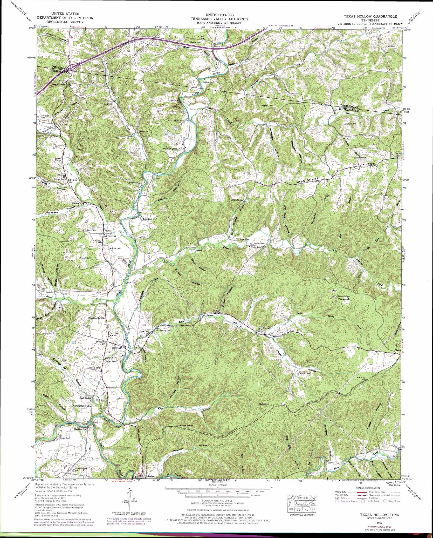
Texas Hollow Topo Map Tennessee
To zoom in, hover over the map of Texas Hollow
USGS Topo Quad 35087h4 - 1:24,000 scale
| Topo Map Name: | Texas Hollow |
| USGS Topo Quad ID: | 35087h4 |
| Print Size: | ca. 21 1/4" wide x 27" high |
| Southeast Coordinates: | 35.875° N latitude / 87.375° W longitude |
| Map Center Coordinates: | 35.9375° N latitude / 87.4375° W longitude |
| U.S. State: | TN |
| Filename: | o35087h4.jpg |
| Download Map JPG Image: | Texas Hollow topo map 1:24,000 scale |
| Map Type: | Topographic |
| Topo Series: | 7.5´ |
| Map Scale: | 1:24,000 |
| Source of Map Images: | United States Geological Survey (USGS) |
| Alternate Map Versions: |
Texas Hollow TN 1936 Download PDF Buy paper map Texas Hollow TN 1952, updated 1957 Download PDF Buy paper map Texas Hollow TN 1952, updated 1970 Download PDF Buy paper map Texas Hollow TN 1952, updated 1970 Download PDF Buy paper map Texas Hollow TN 2010 Download PDF Buy paper map Texas Hollow TN 2013 Download PDF Buy paper map Texas Hollow TN 2016 Download PDF Buy paper map |
1:24,000 Topo Quads surrounding Texas Hollow
Woolworth |
Ruskin |
Vanleer |
Charlotte |
Harpeth Valley |
Mcewen |
Tennessee City |
Dickson |
Burns |
White Bluff |
Bucksnort |
Spot |
Texas Hollow |
Lyles |
Craigfield |
Coble |
Whitfield |
Centerville |
Littlelot |
Primm Springs |
Pleasantville |
Beaverdam Springs |
Sunrise |
Greenfield Bend |
Williamsport |
> Back to 35087e1 at 1:100,000 scale
> Back to 35086a1 at 1:250,000 scale
> Back to U.S. Topo Maps home
Texas Hollow topo map: Gazetteer
Texas Hollow: Areas
Western Highland Rim elevation 190m 623′Texas Hollow: Dams
Kirk Lake Dam elevation 193m 633′Texas Hollow: Populated Places
Matlock Ford elevation 153m 501′Pinewood elevation 158m 518′
Redden (historical) elevation 175m 574′
Rodemer elevation 252m 826′
Texas Hollow: Post Offices
Graham Post Office elevation 170m 557′Texas Hollow: Reservoirs
Kirk Lake elevation 193m 633′Texas Hollow: Ridges
Missionary Ridge elevation 252m 826′Texas Hollow: Springs
Blue Spring elevation 200m 656′Cash Spring elevation 159m 521′
Texas Hollow: Streams
Bear Creek elevation 165m 541′Beaver Creek elevation 153m 501′
Becky Branch elevation 200m 656′
Bee Branch elevation 184m 603′
Big Spring Creek elevation 158m 518′
Double Branch elevation 173m 567′
Garner Creek elevation 156m 511′
Keys Branch elevation 148m 485′
Little Spring Creek elevation 152m 498′
Martin Fork Branch elevation 186m 610′
Mill Creek elevation 144m 472′
Plunders Creek elevation 160m 524′
Pumpkin Branch elevation 187m 613′
Sugarcamp Branch elevation 180m 590′
Turkey Creek elevation 171m 561′
Wells Branch elevation 181m 593′
Texas Hollow: Summits
Cedar Hill elevation 199m 652′Tanbark Hill elevation 247m 810′
Texas Hollow: Valleys
Baker Hollow elevation 189m 620′Betty Hollow elevation 152m 498′
Blue Spring Hollow elevation 171m 561′
Bogle Hollow elevation 164m 538′
Boneyard Hollow elevation 152m 498′
Bridge Hollow elevation 188m 616′
Campground Hollow elevation 144m 472′
Chalkbank Hollow elevation 164m 538′
Christian Hollow elevation 181m 593′
Coleman Hollow elevation 192m 629′
Griffen Hollow elevation 165m 541′
Harberson Hollow elevation 182m 597′
Hickory Hollow elevation 166m 544′
Hog Joint Hollow elevation 177m 580′
Kansas Hollow elevation 162m 531′
Mack Roy Hollow elevation 163m 534′
McAllister Hollow elevation 178m 583′
McCaleb Hollow elevation 165m 541′
Mud Hollow elevation 183m 600′
Murray Hollow elevation 165m 541′
Negro Hollow elevation 184m 603′
Peacock Hollow elevation 158m 518′
Plunder Hollow elevation 161m 528′
Potter Hollow elevation 174m 570′
Simmons Hollow elevation 185m 606′
Texas Hollow elevation 169m 554′
Tie Hollow elevation 174m 570′
Wild Hog Hollow elevation 177m 580′
Wrenn Hollow elevation 161m 528′
Texas Hollow digital topo map on disk
Buy this Texas Hollow topo map showing relief, roads, GPS coordinates and other geographical features, as a high-resolution digital map file on DVD: