Wolf Pit Ridge Topo Map Tennessee
To zoom in, hover over the map of Wolf Pit Ridge
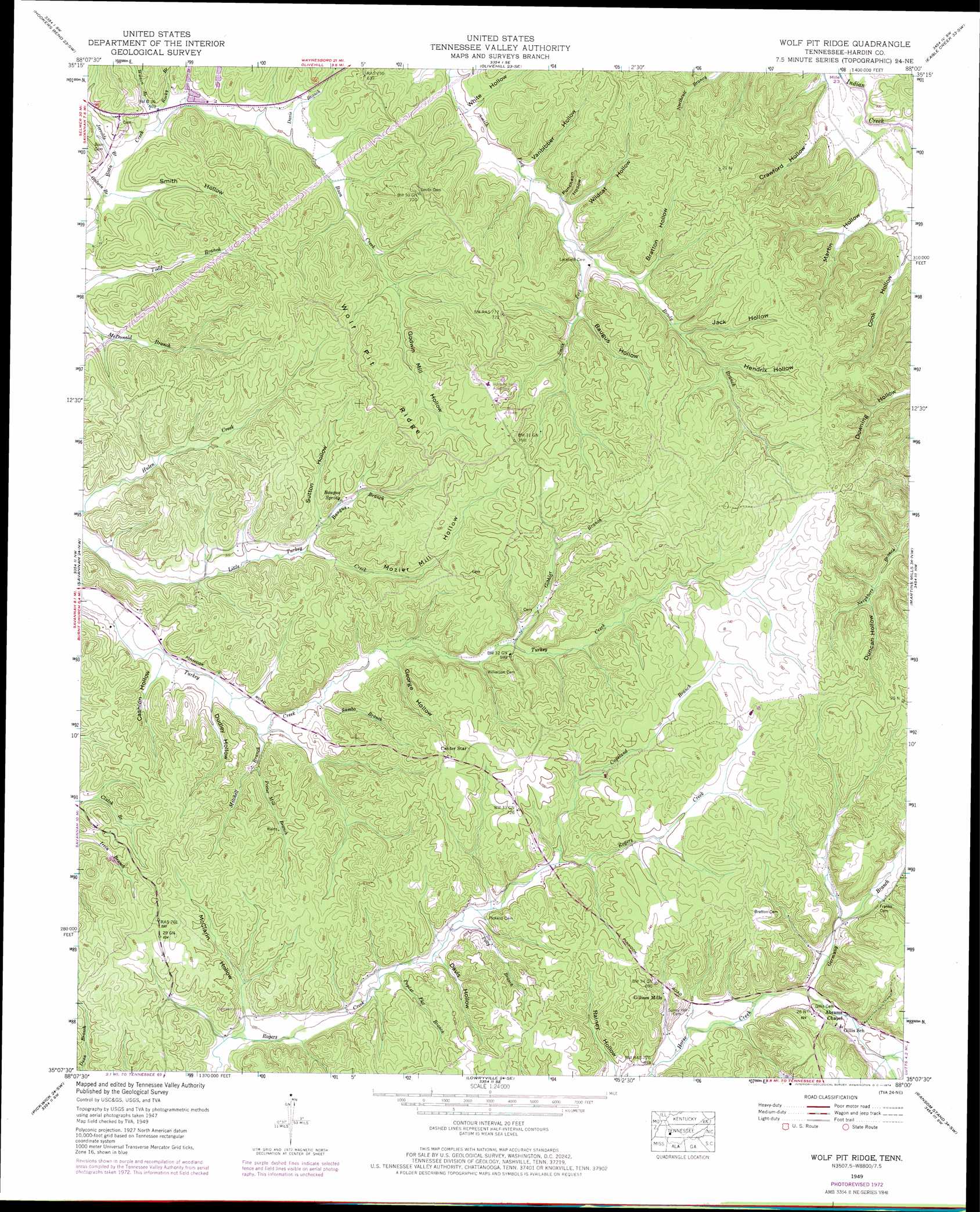
USGS Topo Quad 35088b1 - 1:24,000 scale
| Topo Map Name: | Wolf Pit Ridge |
| USGS Topo Quad ID: | 35088b1 |
| Print Size: | ca. 21 1/4" wide x 27" high |
| Southeast Coordinates: | 35.125° N latitude / 88° W longitude |
| Map Center Coordinates: | 35.1875° N latitude / 88.0625° W longitude |
| U.S. State: | TN |
| Filename: | o35088b1.jpg |
| Download Map JPG Image: | Wolf Pit Ridge topo map 1:24,000 scale |
| Map Type: | Topographic |
| Topo Series: | 7.5´ |
| Map Scale: | 1:24,000 |
| Source of Map Images: | United States Geological Survey (USGS) |
| Alternate Map Versions: |
Wolf Pit Ridge TN 1936 Download PDF Buy paper map Wolf Pit Ridge TN 1949, updated 1973 Download PDF Buy paper map Wolf Pit Ridge TN 1949, updated 1974 Download PDF Buy paper map Wolf Pit Ridge TN 1952 Download PDF Buy paper map Wolf Pit Ridge TN 2010 Download PDF Buy paper map Wolf Pit Ridge TN 2013 Download PDF Buy paper map Wolf Pit Ridge TN 2016 Download PDF Buy paper map |
1:24,000 Topo Quads surrounding Wolf Pit Ridge
Sardis |
Thurman |
Bath Springs |
Clifton |
Leatherwood |
Milledgeville |
Hookers Bend |
Olivehill |
Eagle Creek |
Waynesboro |
Pittsburg Landing |
Savannah |
Wolf Pit Ridge |
Martins Mills |
Three Churches |
Counce |
Pickwick |
Lowryville |
Ransom Stand |
Cypress Inn |
Doskie |
Yellow Creek |
Waterloo |
Wright |
Threet |
> Back to 35088a1 at 1:100,000 scale
> Back to 35088a1 at 1:250,000 scale
> Back to U.S. Topo Maps home
Wolf Pit Ridge topo map: Gazetteer
Wolf Pit Ridge: Populated Places
Center Star elevation 225m 738′Gillises Mills elevation 195m 639′
Wolf Pit Ridge: Ridges
Wolf Pit Ridge elevation 215m 705′Wolf Pit Ridge: Springs
Baugus Spring elevation 171m 561′Wolf Pit Ridge: Streams
Baugus Branch elevation 151m 495′Brady Branch elevation 171m 561′
Copeland Branch elevation 181m 593′
Davis Branch elevation 149m 488′
Germany Branch elevation 176m 577′
Gobbler Branch elevation 170m 557′
Godwin Branch elevation 135m 442′
Jerrolds Branch elevation 138m 452′
Mitchell Branch elevation 145m 475′
Nichols Branch elevation 185m 606′
Petty Branch elevation 170m 557′
Poplar Flat Branch elevation 168m 551′
Porter Mill Branch elevation 151m 495′
Rocky Branch elevation 138m 452′
Sambo Branch elevation 149m 488′
Smith Branch elevation 136m 446′
Wilson Branch elevation 141m 462′
Wolf Pit Ridge: Valleys
Baugus Hollow elevation 172m 564′Bratton Hollow elevation 174m 570′
Cashion Hollow elevation 142m 465′
Cook Hollow elevation 151m 495′
Crawford Hollow elevation 143m 469′
Davis Hollow elevation 172m 564′
Dudley Hollow elevation 145m 475′
Duncan Hollow elevation 190m 623′
George Hollow elevation 156m 511′
Hendrix Hollow elevation 189m 620′
Jack Hollow elevation 177m 580′
Martin Hollow elevation 146m 479′
McClarin Hollow elevation 157m 515′
Puncheon Hollow elevation 158m 518′
Rainey Hollow elevation 173m 567′
Smith Hollow elevation 137m 449′
Sutton Hollow elevation 163m 534′
Vanbibber Hollow elevation 156m 511′
White Hollow elevation 151m 495′
Wildcat Hollow elevation 158m 518′
Wolf Pit Ridge digital topo map on disk
Buy this Wolf Pit Ridge topo map showing relief, roads, GPS coordinates and other geographical features, as a high-resolution digital map file on DVD: