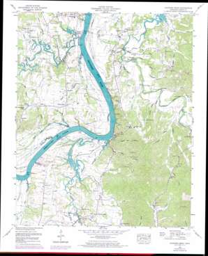
Hookers Bend Topo Map Tennessee
To zoom in, hover over the map of Hookers Bend
USGS Topo Quad 35088c2 - 1:24,000 scale
| Topo Map Name: | Hookers Bend |
| USGS Topo Quad ID: | 35088c2 |
| Print Size: | ca. 21 1/4" wide x 27" high |
| Southeast Coordinates: | 35.25° N latitude / 88.125° W longitude |
| Map Center Coordinates: | 35.3125° N latitude / 88.1875° W longitude |
| U.S. State: | TN |
| Filename: | o35088c2.jpg |
| Download Map JPG Image: | Hookers Bend topo map 1:24,000 scale |
| Map Type: | Topographic |
| Topo Series: | 7.5´ |
| Map Scale: | 1:24,000 |
| Source of Map Images: | United States Geological Survey (USGS) |
| Alternate Map Versions: |
Hookers Bend TN 1936 Download PDF Buy paper map Hookers Bend TN 1949, updated 1952 Download PDF Buy paper map Hookers Bend TN 1949, updated 1974 Download PDF Buy paper map Hookers Bend TN 2010 Download PDF Buy paper map Hookers Bend TN 2013 Download PDF Buy paper map Hookers Bend TN 2016 Download PDF Buy paper map |
1:24,000 Topo Quads surrounding Hookers Bend
> Back to 35088a1 at 1:100,000 scale
> Back to 35088a1 at 1:250,000 scale
> Back to U.S. Topo Maps home
Hookers Bend topo map: Gazetteer
Hookers Bend: Bars
Petticoat Riffles elevation 110m 360′Hookers Bend: Bends
Hookers Bend elevation 123m 403′Pitts Bend elevation 129m 423′
Hookers Bend: Bridges
Lower Bridge elevation 111m 364′Middle Bridge elevation 111m 364′
Paulks Mill Bridge elevation 114m 374′
Upper Bridge elevation 122m 400′
White Oak Bridge elevation 110m 360′
Hookers Bend: Capes
The Fork elevation 124m 406′Hookers Bend: Cliffs
Flat Bluff elevation 113m 370′Huey Bluff elevation 125m 410′
Love Bluff elevation 122m 400′
Mary Jane Bluff elevation 120m 393′
Hookers Bend: Crossings
Cerro Gordo Ferry (historical) elevation 110m 360′Cravens Ferry (historical) elevation 110m 360′
Hardin Creek Ferry (historical) elevation 110m 360′
Mays Ferry (historical) elevation 110m 360′
Saltillo Ferry elevation 109m 357′
Hookers Bend: Islands
Davis Island elevation 114m 374′Hookers Bend: Populated Places
Bucktown elevation 128m 419′Centerview elevation 161m 528′
Cerro Gordo elevation 124m 406′
Holtsville elevation 154m 505′
Hookers Bend elevation 123m 403′
New Harmony elevation 155m 508′
Oak Grove elevation 127m 416′
Paulks (historical) elevation 134m 439′
Stringtown elevation 121m 396′
Swift elevation 158m 518′
Hookers Bend: Springs
Sulphur Well Spring elevation 113m 370′Hookers Bend: Streams
Alexander Branch elevation 123m 403′Anderson Branch elevation 110m 360′
Bell Branch elevation 116m 380′
Blue Spring Branch elevation 113m 370′
Cagle Branch elevation 112m 367′
Callens Branch elevation 114m 374′
Canning Factory Branch elevation 110m 360′
Cypress Pond Slough elevation 111m 364′
Cypress Slough elevation 110m 360′
Davis Lagoon elevation 111m 364′
Doran Slough elevation 110m 360′
Duke Branch elevation 116m 380′
Filgo Branch elevation 114m 374′
Haislip Branch elevation 112m 367′
Hardin Branch elevation 110m 360′
Hobbs Mill Branch elevation 110m 360′
Horse Creek elevation 110m 360′
Lick Branch elevation 110m 360′
Love Branch elevation 119m 390′
Maple Slash Slough elevation 110m 360′
Miles Creek elevation 110m 360′
Miller Slough elevation 111m 364′
Orr Branch elevation 115m 377′
Pony Creek elevation 109m 357′
Sandford Branch elevation 114m 374′
Sawmill Branch elevation 110m 360′
Shady Hill Branch elevation 118m 387′
Stanfield Branch elevation 118m 387′
Stanfield Branch elevation 119m 390′
Sulphur Branch elevation 111m 364′
Sweetwater Branch elevation 115m 377′
Thacker Branch elevation 120m 393′
Thompson Branch elevation 116m 380′
Turner Branch elevation 126m 413′
Walker Branch elevation 110m 360′
Welch Branch elevation 110m 360′
White Oak Creek elevation 111m 364′
Whitlow Branch elevation 119m 390′
Hookers Bend: Valleys
Clemmitt Branch elevation 132m 433′Hookers Bend digital topo map on disk
Buy this Hookers Bend topo map showing relief, roads, GPS coordinates and other geographical features, as a high-resolution digital map file on DVD:


