Sardis Topo Map Tennessee
To zoom in, hover over the map of Sardis
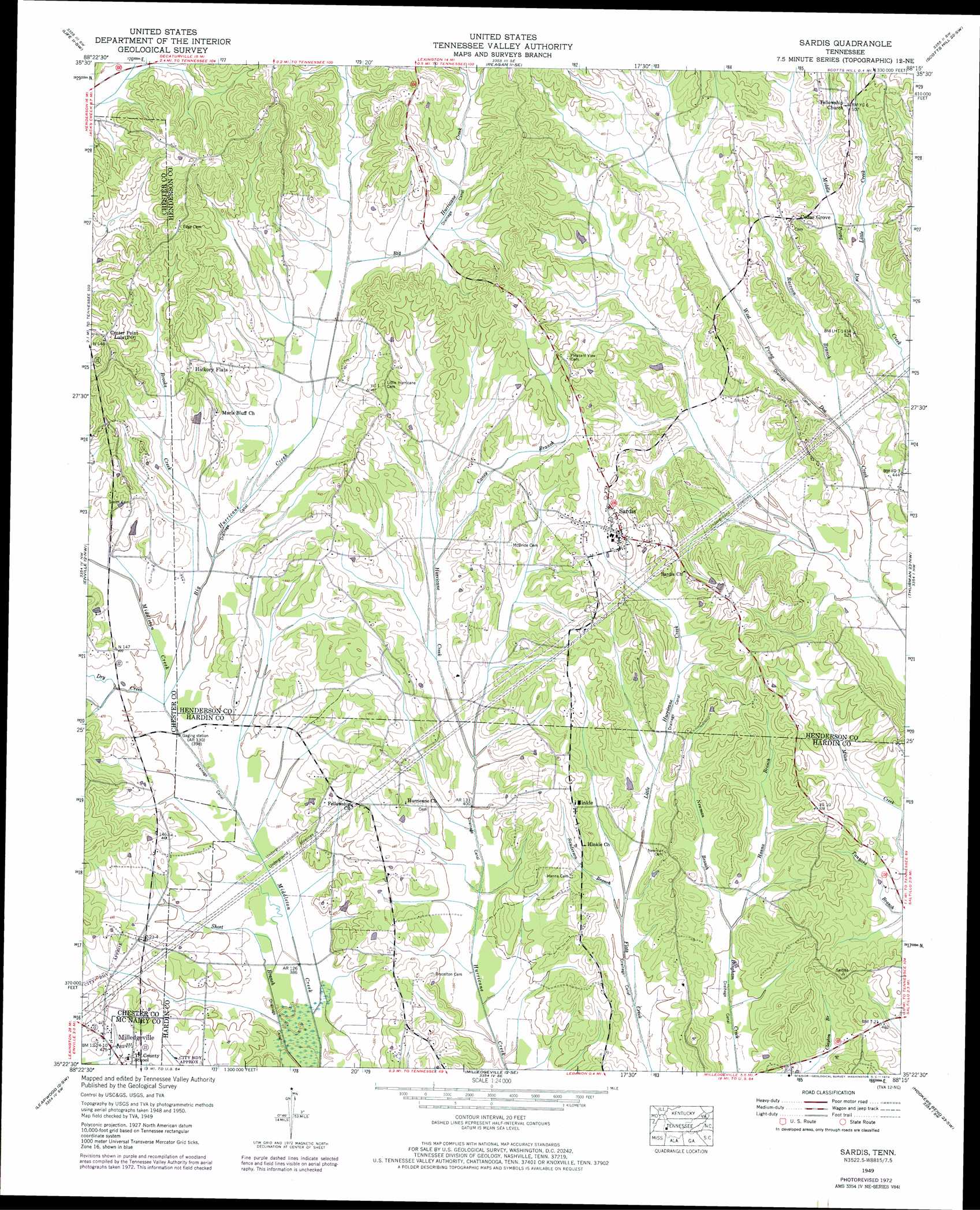
USGS Topo Quad 35088d3 - 1:24,000 scale
| Topo Map Name: | Sardis |
| USGS Topo Quad ID: | 35088d3 |
| Print Size: | ca. 21 1/4" wide x 27" high |
| Southeast Coordinates: | 35.375° N latitude / 88.25° W longitude |
| Map Center Coordinates: | 35.4375° N latitude / 88.3125° W longitude |
| U.S. State: | TN |
| Filename: | o35088d3.jpg |
| Download Map JPG Image: | Sardis topo map 1:24,000 scale |
| Map Type: | Topographic |
| Topo Series: | 7.5´ |
| Map Scale: | 1:24,000 |
| Source of Map Images: | United States Geological Survey (USGS) |
| Alternate Map Versions: |
Sardis TN 1936 Download PDF Buy paper map Sardis TN 1949, updated 1952 Download PDF Buy paper map Sardis TN 1949, updated 1974 Download PDF Buy paper map Sardis TN 2010 Download PDF Buy paper map Sardis TN 2013 Download PDF Buy paper map Sardis TN 2016 Download PDF Buy paper map |
1:24,000 Topo Quads surrounding Sardis
Juno |
Lexington |
Chesterfield |
Parsons |
Jeanette |
Luray |
Life |
Reagan |
Scotts Hill |
Perryville |
Jacks Creek |
Enville |
Sardis |
Thurman |
Bath Springs |
Mount Peter |
Leapwood |
Milledgeville |
Hookers Bend |
Olivehill |
Purdy |
Stantonville |
Pittsburg Landing |
Savannah |
Wolf Pit Ridge |
> Back to 35088a1 at 1:100,000 scale
> Back to 35088a1 at 1:250,000 scale
> Back to U.S. Topo Maps home
Sardis topo map: Gazetteer
Sardis: Canals
Alexander Creek Canal elevation 116m 380′Hurricane Creek Canal elevation 116m 380′
Middleton Creek Canal elevation 117m 383′
Sardis: Dams
Claiborne Wells Dam elevation 125m 410′Sardis: Populated Places
Cedar Grove elevation 148m 485′Center Point Lula elevation 166m 544′
Hickory Flats elevation 147m 482′
Hinkle elevation 148m 485′
Sardis elevation 157m 515′
Sardis: Reservoirs
Claiborne Wells Lake elevation 125m 410′Sardis: Ridges
Presley Ridge elevation 149m 488′Sardis: Streams
Big Hurricane Creek elevation 119m 390′Brooks Creek elevation 122m 400′
Caney Branch elevation 128m 419′
Dry Creek elevation 119m 390′
Hanna Branch elevation 122m 400′
Little Creek elevation 127m 416′
Little Hurricane Creek elevation 120m 393′
Newman Branch elevation 122m 400′
Raccoon Branch elevation 122m 400′
Sanderson Branch elevation 120m 393′
Sardis digital topo map on disk
Buy this Sardis topo map showing relief, roads, GPS coordinates and other geographical features, as a high-resolution digital map file on DVD: