Perryville Topo Map Tennessee
To zoom in, hover over the map of Perryville
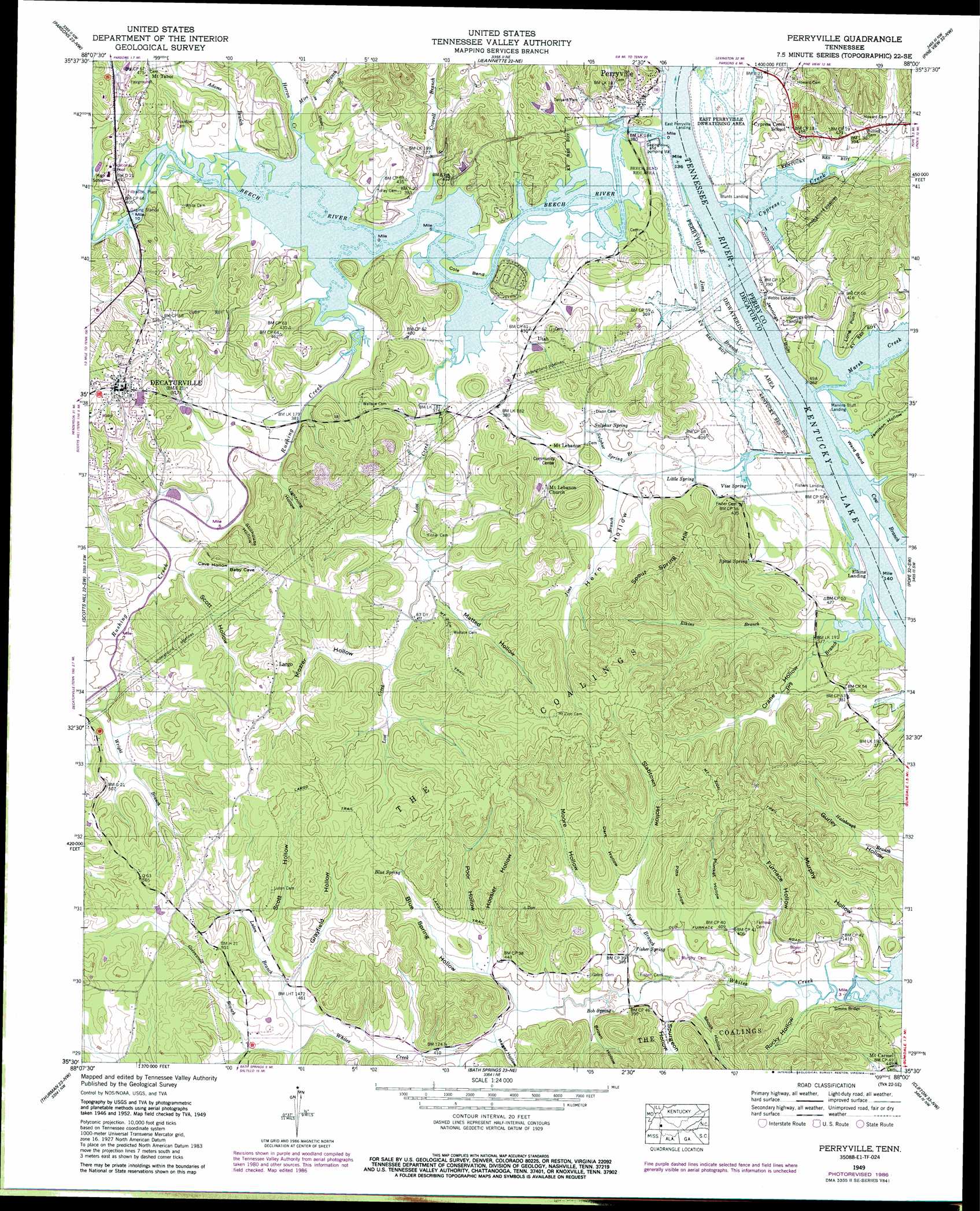
USGS Topo Quad 35088e1 - 1:24,000 scale
| Topo Map Name: | Perryville |
| USGS Topo Quad ID: | 35088e1 |
| Print Size: | ca. 21 1/4" wide x 27" high |
| Southeast Coordinates: | 35.5° N latitude / 88° W longitude |
| Map Center Coordinates: | 35.5625° N latitude / 88.0625° W longitude |
| U.S. State: | TN |
| Filename: | o35088e1.jpg |
| Download Map JPG Image: | Perryville topo map 1:24,000 scale |
| Map Type: | Topographic |
| Topo Series: | 7.5´ |
| Map Scale: | 1:24,000 |
| Source of Map Images: | United States Geological Survey (USGS) |
| Alternate Map Versions: |
Perryville TN 1936 Download PDF Buy paper map Perryville TN 1949, updated 1952 Download PDF Buy paper map Perryville TN 1949, updated 1978 Download PDF Buy paper map Perryville TN 1949, updated 1987 Download PDF Buy paper map Perryville TN 2010 Download PDF Buy paper map Perryville TN 2013 Download PDF Buy paper map Perryville TN 2016 Download PDF Buy paper map |
1:24,000 Topo Quads surrounding Perryville
Yuma |
Holladay |
Sugar Tree |
Daniels Landing |
Lobelville |
Chesterfield |
Parsons |
Jeanette |
Pine View |
Chestnut Grove |
Reagan |
Scotts Hill |
Perryville |
Pope |
Linden |
Sardis |
Thurman |
Bath Springs |
Clifton |
Leatherwood |
Milledgeville |
Hookers Bend |
Olivehill |
Eagle Creek |
Waynesboro |
> Back to 35088e1 at 1:100,000 scale
> Back to 35088a1 at 1:250,000 scale
> Back to U.S. Topo Maps home
Perryville topo map: Gazetteer
Perryville: Basins
Perryville Dewatering Area elevation 111m 364′Perryville: Bends
Beech Bend elevation 110m 360′Cole Bend elevation 110m 360′
Ward Bend elevation 113m 370′
Perryville: Bridges
Simms Bridge elevation 110m 360′Perryville: Capes
Long Point elevation 140m 459′Perryville: Cliffs
Jennings Bluff elevation 116m 380′Perryville: Crossings
Perryville Ferry (historical) elevation 109m 357′Wards Ferry (historical) elevation 109m 357′
Perryville: Lakes
Horseshoe Pond (historical) elevation 109m 357′Round Pond (historical) elevation 113m 370′
Perryville: Parks
Beech Bend Recreation Area elevation 116m 380′Tanyard Park elevation 118m 387′
Perryville: Populated Places
Decaturville elevation 158m 518′Largo elevation 170m 557′
Mount Lebanon elevation 127m 416′
Mount Tabor elevation 144m 472′
Perryville elevation 118m 387′
Utah elevation 119m 390′
Perryville: Post Offices
Perryville Post Office (historical) elevation 121m 396′Perryville: Springs
Blue Spring elevation 150m 492′Bob Spring elevation 119m 390′
Fisher Spring elevation 121m 396′
Little Spring elevation 113m 370′
Spout Spring elevation 123m 403′
Sulphur Spring elevation 121m 396′
Vise Spring elevation 115m 377′
Perryville: Streams
Adams Branch elevation 109m 357′Beech River elevation 109m 357′
Buck Branch elevation 121m 396′
Crowell Branch elevation 109m 357′
Cypress Creek elevation 109m 357′
Dry Branch elevation 109m 357′
Elkins Branch elevation 109m 357′
Fisher Branch elevation 113m 370′
Greenwood Branch elevation 132m 433′
Herron Creek elevation 109m 357′
Jims Branch elevation 110m 360′
Lost Creek elevation 109m 357′
Luton Branch elevation 128m 419′
Marsh Creek elevation 109m 357′
Mire Branch elevation 113m 370′
Pikes Peak Branch elevation 109m 357′
Rushing Creek elevation 109m 357′
Sulphur Spring Branch elevation 113m 370′
Wright Branch elevation 119m 390′
Perryville: Summits
Spout Spring Hill elevation 187m 613′The Coalings elevation 167m 547′
Perryville: Trails
Largo Trail elevation 172m 564′Mount Zion Trail elevation 182m 597′
Perryville: Valleys
Beasley Hollow elevation 120m 393′Blue Spring Hollow elevation 120m 393′
Brown Hollow elevation 117m 383′
Cave Hollow elevation 124m 406′
Crane Hollow elevation 110m 360′
Dark Hollow elevation 124m 406′
Furnace Hollow elevation 114m 374′
Grayfield Hollow elevation 134m 439′
Hern Hollow elevation 116m 380′
Hoosier Hollow elevation 125m 410′
Jamison Hollow elevation 109m 357′
Lightning Hollow elevation 115m 377′
Mager Hollow elevation 121m 396′
Moore Hollow elevation 120m 393′
Mozier Hollow elevation 126m 413′
Murphy Hollow elevation 111m 364′
Pitts Hollow elevation 115m 377′
Plunket Hollow elevation 116m 380′
Poor Hollow elevation 126m 413′
Rocky Hollow elevation 115m 377′
Scott Hollow elevation 138m 452′
Scott Hollow elevation 123m 403′
Shook Hollow elevation 115m 377′
Slabtown Hollow elevation 122m 400′
Spurgeon Hollow elevation 115m 377′
Stillhouse Hollow elevation 115m 377′
Perryville digital topo map on disk
Buy this Perryville topo map showing relief, roads, GPS coordinates and other geographical features, as a high-resolution digital map file on DVD: