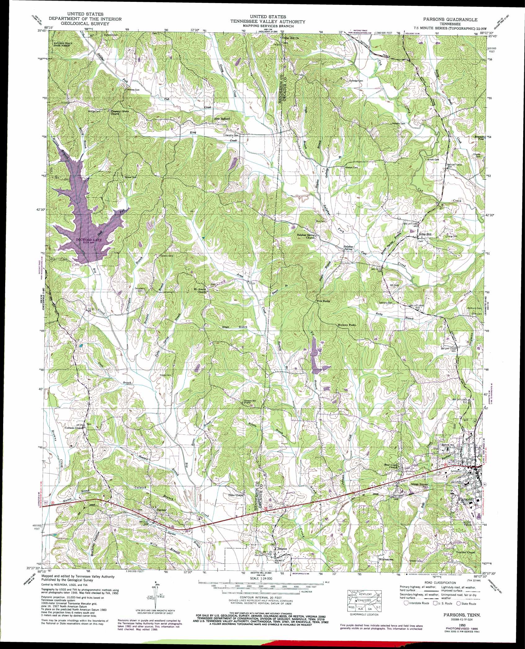
Parsons Topo Map Tennessee
To zoom in, hover over the map of Parsons
USGS Topo Quad 35088f2 - 1:24,000 scale
| Topo Map Name: | Parsons |
| USGS Topo Quad ID: | 35088f2 |
| Print Size: | ca. 21 1/4" wide x 27" high |
| Southeast Coordinates: | 35.625° N latitude / 88.125° W longitude |
| Map Center Coordinates: | 35.6875° N latitude / 88.1875° W longitude |
| U.S. State: | TN |
| Filename: | o35088f2.jpg |
| Download Map JPG Image: | Parsons topo map 1:24,000 scale |
| Map Type: | Topographic |
| Topo Series: | 7.5´ |
| Map Scale: | 1:24,000 |
| Source of Map Images: | United States Geological Survey (USGS) |
| Alternate Map Versions: |
Parsons TN 1936 Download PDF Buy paper map Parsons TN 1950, updated 1953 Download PDF Buy paper map Parsons TN 1950, updated 1987 Download PDF Buy paper map Parsons TN 2010 Download PDF Buy paper map Parsons TN 2013 Download PDF Buy paper map Parsons TN 2016 Download PDF Buy paper map |
1:24,000 Topo Quads surrounding Parsons
Palmer Shelter |
Buena Vista |
Seventeen Creek |
Rockport |
Hustburg |
Clarksburg |
Yuma |
Holladay |
Sugar Tree |
Daniels Landing |
Lexington |
Chesterfield |
Parsons |
Jeanette |
Pine View |
Life |
Reagan |
Scotts Hill |
Perryville |
Pope |
Enville |
Sardis |
Thurman |
Bath Springs |
Clifton |
> Back to 35088e1 at 1:100,000 scale
> Back to 35088a1 at 1:250,000 scale
> Back to U.S. Topo Maps home
Parsons topo map: Gazetteer
Parsons: Airports
Scott Field elevation 157m 515′Parsons: Dams
Dogwood Dam elevation 135m 442′Lexington Management Corporation Dam elevation 142m 465′
Refish Number One Dam elevation 132m 433′
Refish Number Two Dam elevation 133m 436′
Parsons: Populated Places
Beacon elevation 125m 410′Beacon Junction elevation 126m 413′
Bear Creek elevation 159m 521′
Bible Hill elevation 140m 459′
Blankenship (historical) elevation 151m 495′
Darden elevation 141m 462′
Five Forks elevation 168m 551′
Hickory Forks elevation 170m 557′
New Safford elevation 143m 469′
Old Safford (historical) elevation 153m 501′
Parsons elevation 151m 495′
Sulphur Springs (historical) elevation 123m 403′
Wilkinstown elevation 142m 465′
Parsons: Post Offices
Darden Post Office elevation 125m 410′Parsons: Reservoirs
Dogwood Lake elevation 135m 442′Lexington Management Corporation Lake elevation 142m 465′
Refish Number One Lake elevation 132m 433′
Refish Number Two Lake elevation 133m 436′
Parsons: Springs
Sulphur Spring elevation 120m 393′Parsons: Streams
Big Branch elevation 121m 396′Bradfield Branch elevation 120m 393′
Brown Spring Branch elevation 117m 383′
Buckner Branch elevation 126m 413′
Cagle Branch elevation 125m 410′
Carrington Branch elevation 121m 396′
Colwick Branch elevation 114m 374′
Davis Branch elevation 119m 390′
Dodd Branch elevation 115m 377′
Evans Branch elevation 127m 416′
Gilbert Branch elevation 122m 400′
Greasy Creek elevation 126m 413′
Gulledge Branch elevation 121m 396′
Hawkes Branch elevation 122m 400′
Hayes Branch elevation 119m 390′
Hayes Branch elevation 124m 406′
Howard Branch elevation 114m 374′
King Creek elevation 124m 406′
Mackey Branch elevation 117m 383′
McCoy Branch elevation 135m 442′
Milton Branch elevation 135m 442′
Reeves Branch elevation 116m 380′
Roberts Branch elevation 119m 390′
Rocky Branch elevation 122m 400′
Rushing Branch elevation 123m 403′
Shell Fork elevation 122m 400′
Shipman Creek elevation 119m 390′
Tubbs Spring Branch elevation 119m 390′
West Fork Cub Creek elevation 122m 400′
Wilson Branch elevation 116m 380′
Parsons: Valleys
Duke Hollow elevation 120m 393′Flowers Hollow elevation 118m 387′
Spring Hollow elevation 134m 439′
Parsons digital topo map on disk
Buy this Parsons topo map showing relief, roads, GPS coordinates and other geographical features, as a high-resolution digital map file on DVD: