Sugar Tree Topo Map Tennessee
To zoom in, hover over the map of Sugar Tree
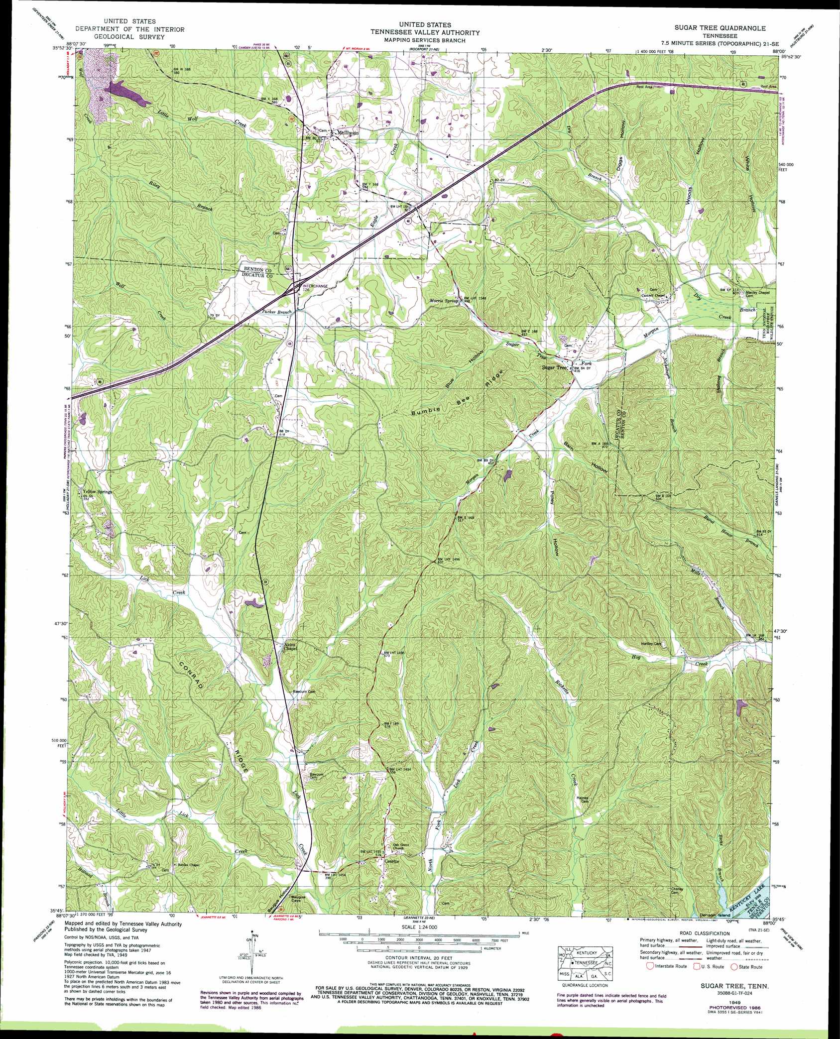
USGS Topo Quad 35088g1 - 1:24,000 scale
| Topo Map Name: | Sugar Tree |
| USGS Topo Quad ID: | 35088g1 |
| Print Size: | ca. 21 1/4" wide x 27" high |
| Southeast Coordinates: | 35.75° N latitude / 88° W longitude |
| Map Center Coordinates: | 35.8125° N latitude / 88.0625° W longitude |
| U.S. State: | TN |
| Filename: | o35088g1.jpg |
| Download Map JPG Image: | Sugar Tree topo map 1:24,000 scale |
| Map Type: | Topographic |
| Topo Series: | 7.5´ |
| Map Scale: | 1:24,000 |
| Source of Map Images: | United States Geological Survey (USGS) |
| Alternate Map Versions: |
Sugar Tree TN 1936 Download PDF Buy paper map Sugar Tree TN 1949, updated 1953 Download PDF Buy paper map Sugar Tree TN 1949, updated 1987 Download PDF Buy paper map Sugar Tree TN 2010 Download PDF Buy paper map Sugar Tree TN 2013 Download PDF Buy paper map Sugar Tree TN 2016 Download PDF Buy paper map |
1:24,000 Topo Quads surrounding Sugar Tree
Vale |
Bruceton |
Camden |
Johnsonville |
Waverly |
Buena Vista |
Seventeen Creek |
Rockport |
Hustburg |
Hurricane Mills |
Yuma |
Holladay |
Sugar Tree |
Daniels Landing |
Lobelville |
Chesterfield |
Parsons |
Jeanette |
Pine View |
Chestnut Grove |
Reagan |
Scotts Hill |
Perryville |
Pope |
Linden |
> Back to 35088e1 at 1:100,000 scale
> Back to 35088a1 at 1:250,000 scale
> Back to U.S. Topo Maps home
Sugar Tree topo map: Gazetteer
Sugar Tree: Crossings
Interchange 126 elevation 184m 603′Sugar Tree: Populated Places
Akins Chapel elevation 133m 436′Bliss (historical) elevation 133m 436′
Cozette elevation 154m 505′
Etna (historical) elevation 115m 377′
McIllwain elevation 188m 616′
Oakview (historical) elevation 115m 377′
Sugar Tree elevation 127m 416′
Yellow Springs elevation 165m 541′
Sugar Tree: Post Offices
Sugar Tree Post Office elevation 126m 413′Sugar Tree: Ridges
Bumble Bee Ridge elevation 186m 610′Conrad Ridge elevation 167m 547′
Sugar Tree: Springs
Morris Spring elevation 151m 495′Sugar Tree: Streams
Becks Branch elevation 109m 357′Dry Branch elevation 110m 360′
Little Lick Creek elevation 114m 374′
Little Wolf Creek elevation 125m 410′
Mills Branch elevation 115m 377′
Nickeltown Branch elevation 116m 380′
Riley Branch elevation 133m 436′
Shakerag Branch elevation 111m 364′
Sugar Tree Fork elevation 120m 393′
Tucker Branch elevation 173m 567′
Sugar Tree: Valleys
Barn Hollow elevation 128m 419′Baugus Hollow elevation 118m 387′
Blue Hollow elevation 139m 456′
Diggs Hollow elevation 131m 429′
Poley Hollow elevation 131m 429′
Woods Hollow elevation 121m 396′
Sugar Tree digital topo map on disk
Buy this Sugar Tree topo map showing relief, roads, GPS coordinates and other geographical features, as a high-resolution digital map file on DVD: