Jones Topo Map Tennessee
To zoom in, hover over the map of Jones
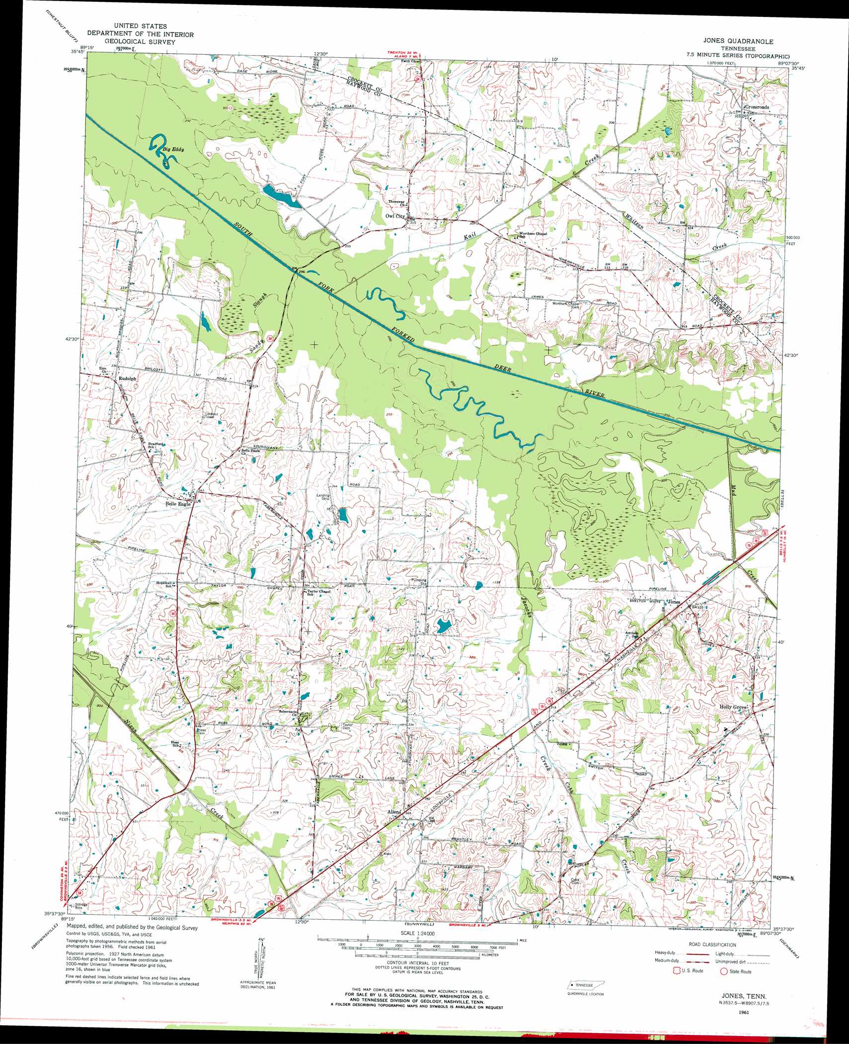
USGS Topo Quad 35089f2 - 1:24,000 scale
| Topo Map Name: | Jones |
| USGS Topo Quad ID: | 35089f2 |
| Print Size: | ca. 21 1/4" wide x 27" high |
| Southeast Coordinates: | 35.625° N latitude / 89.125° W longitude |
| Map Center Coordinates: | 35.6875° N latitude / 89.1875° W longitude |
| U.S. State: | TN |
| Filename: | o35089f2.jpg |
| Download Map JPG Image: | Jones topo map 1:24,000 scale |
| Map Type: | Topographic |
| Topo Series: | 7.5´ |
| Map Scale: | 1:24,000 |
| Source of Map Images: | United States Geological Survey (USGS) |
| Alternate Map Versions: |
Jones TN 1961, updated 1963 Download PDF Buy paper map Jones TN 1961, updated 1991 Download PDF Buy paper map Jones TN 2010 Download PDF Buy paper map Jones TN 2013 Download PDF Buy paper map Jones TN 2016 Download PDF Buy paper map |
1:24,000 Topo Quads surrounding Jones
Fowlkes |
Bonicord |
Friendship |
Brazil |
Trenton |
Gates |
Chestnut Bluff |
Maury City |
Alamo |
Humboldt |
Durhamville |
Tibbs |
Jones |
Bells |
Adair |
Turnpike |
Brownsville |
Sunnyhill |
Denmark |
Westover |
Stanton |
Dancyville |
Hillville |
Mercer |
Teague |
> Back to 35089e1 at 1:100,000 scale
> Back to 35088a1 at 1:250,000 scale
> Back to U.S. Topo Maps home
Jones topo map: Gazetteer
Jones: Airports
Thornton Airport elevation 106m 347′Jones: Dams
William A Jameson Lake Dam elevation 105m 344′Jones: Islands
Island Number Eleven elevation 87m 285′Island Number Ten elevation 87m 285′
Island Number Twelve elevation 90m 295′
Jones: Lakes
Big Eddy elevation 87m 285′Jones: Populated Places
Allens elevation 114m 374′Belle Eagle elevation 102m 334′
Bradford elevation 112m 367′
Crossroads elevation 109m 357′
Holly Grove elevation 105m 344′
Jones elevation 97m 318′
Owl City elevation 94m 308′
Jones: Reservoirs
William A Jameson Lake elevation 105m 344′Jones: Streams
Cobb Creek elevation 94m 308′Jacocks Creek elevation 90m 295′
Kail Creek elevation 88m 288′
Mud Creek elevation 91m 298′
Sandy Slough elevation 90m 295′
Whitson Creek elevation 90m 295′
Jones digital topo map on disk
Buy this Jones topo map showing relief, roads, GPS coordinates and other geographical features, as a high-resolution digital map file on DVD: