Fort Pillow Topo Map Tennessee
To zoom in, hover over the map of Fort Pillow
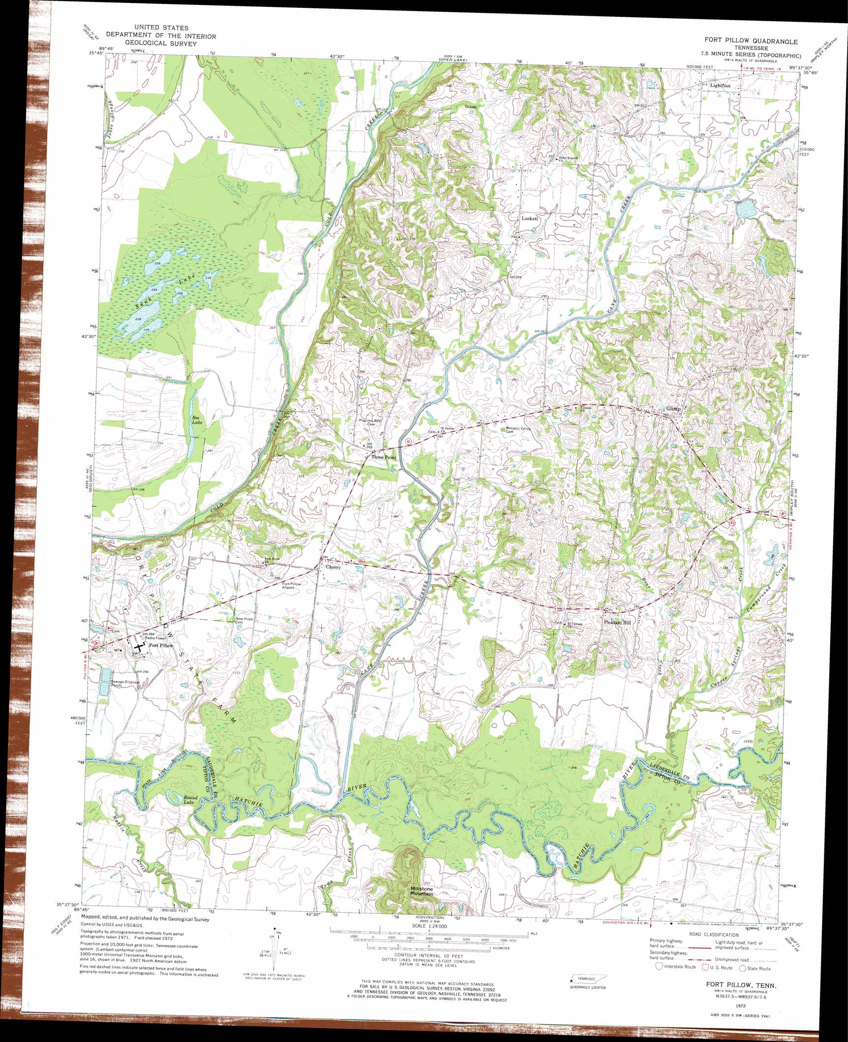
USGS Topo Quad 35089f6 - 1:24,000 scale
| Topo Map Name: | Fort Pillow |
| USGS Topo Quad ID: | 35089f6 |
| Print Size: | ca. 21 1/4" wide x 27" high |
| Southeast Coordinates: | 35.625° N latitude / 89.625° W longitude |
| Map Center Coordinates: | 35.6875° N latitude / 89.6875° W longitude |
| U.S. State: | TN |
| Filename: | o35089f6.jpg |
| Download Map JPG Image: | Fort Pillow topo map 1:24,000 scale |
| Map Type: | Topographic |
| Topo Series: | 7.5´ |
| Map Scale: | 1:24,000 |
| Source of Map Images: | United States Geological Survey (USGS) |
| Alternate Map Versions: |
Fort Pillow TN 1972, updated 1974 Download PDF Buy paper map Fort Pillow TN 2010 Download PDF Buy paper map Fort Pillow TN 2013 Download PDF Buy paper map Fort Pillow TN 2016 Download PDF Buy paper map |
1:24,000 Topo Quads surrounding Fort Pillow
Blytheville |
Armorel |
Chic |
Knob Creek |
Fowlkes |
Luxora |
Rosa |
Open Lake |
Ripley North |
Gates |
Osceola |
Golddust |
Fort Pillow |
Ripley South |
Durhamville |
Nodena |
Gilt Edge |
Covington |
Gift |
Turnpike |
Drummonds |
Munford |
Brighton |
Mason |
Stanton |
> Back to 35089e1 at 1:100,000 scale
> Back to 35088a1 at 1:250,000 scale
> Back to U.S. Topo Maps home
Fort Pillow topo map: Gazetteer
Fort Pillow: Dams
Cane Creek Number Twenty-two Dam elevation 90m 295′Ried Dunavant Dam elevation 85m 278′
Fort Pillow: Lakes
Bee Lake elevation 72m 236′Round Lake elevation 74m 242′
Sunk Lake elevation 73m 239′
Fort Pillow: Populated Places
Cherry elevation 88m 288′Fort Pillow elevation 85m 278′
Glimp elevation 114m 374′
Lightfoot elevation 96m 314′
Luckett elevation 94m 308′
Mack elevation 92m 301′
Olive Branch elevation 98m 321′
Pleasant Hill elevation 99m 324′
Three Point elevation 86m 282′
Fort Pillow: Reservoirs
Cane Creek Number Twenty-two Lake elevation 90m 295′Ried Dunavant Lake elevation 85m 278′
Fort Pillow: Streams
Boar Creek elevation 75m 246′Campground Creek elevation 83m 272′
Cane Creek elevation 72m 236′
Copper Springs Creek elevation 73m 239′
Mathis Creek elevation 71m 232′
Town Creek elevation 72m 236′
Fort Pillow: Summits
Millstone Mountain elevation 121m 396′Fort Pillow digital topo map on disk
Buy this Fort Pillow topo map showing relief, roads, GPS coordinates and other geographical features, as a high-resolution digital map file on DVD: