Chestnut Bluff Topo Map Tennessee
To zoom in, hover over the map of Chestnut Bluff
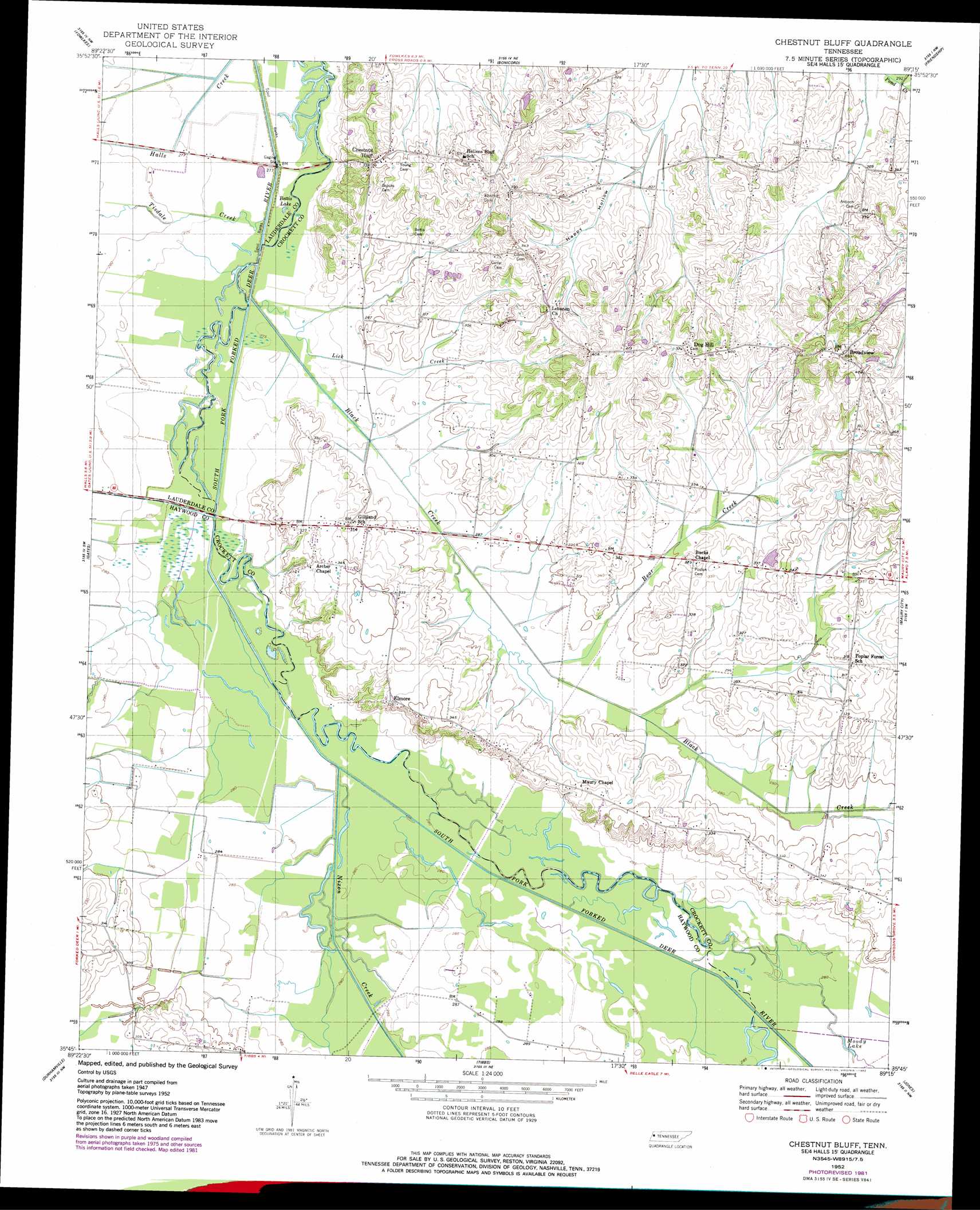
USGS Topo Quad 35089g3 - 1:24,000 scale
| Topo Map Name: | Chestnut Bluff |
| USGS Topo Quad ID: | 35089g3 |
| Print Size: | ca. 21 1/4" wide x 27" high |
| Southeast Coordinates: | 35.75° N latitude / 89.25° W longitude |
| Map Center Coordinates: | 35.8125° N latitude / 89.3125° W longitude |
| U.S. State: | TN |
| Filename: | o35089g3.jpg |
| Download Map JPG Image: | Chestnut Bluff topo map 1:24,000 scale |
| Map Type: | Topographic |
| Topo Series: | 7.5´ |
| Map Scale: | 1:24,000 |
| Source of Map Images: | United States Geological Survey (USGS) |
| Alternate Map Versions: |
Chestnut Bluff TN 1952, updated 1953 Download PDF Buy paper map Chestnut Bluff TN 1952, updated 1982 Download PDF Buy paper map Chestnut Bluff TN 2010 Download PDF Buy paper map Chestnut Bluff TN 2013 Download PDF Buy paper map Chestnut Bluff TN 2016 Download PDF Buy paper map |
1:24,000 Topo Quads surrounding Chestnut Bluff
Caruthersville Se |
Dyersburg |
Newbern |
Tatumville |
Yorkville |
Knob Creek |
Fowlkes |
Bonicord |
Friendship |
Brazil |
Ripley North |
Gates |
Chestnut Bluff |
Maury City |
Alamo |
Ripley South |
Durhamville |
Tibbs |
Jones |
Bells |
Gift |
Turnpike |
Brownsville |
Sunnyhill |
Denmark |
> Back to 35089e1 at 1:100,000 scale
> Back to 35088a1 at 1:250,000 scale
> Back to U.S. Topo Maps home
Chestnut Bluff topo map: Gazetteer
Chestnut Bluff: Bridges
Chestnut Bluff Bridge elevation 82m 269′Chestnut Bluff: Islands
Island Number Eight (historical) elevation 85m 278′Island Number Seven (historical) elevation 82m 269′
Island Number Six elevation 82m 269′
Number Nine Island (historical) elevation 85m 278′
Chestnut Bluff: Lakes
Bettis Lake elevation 82m 269′Moody Lake elevation 85m 278′
Chestnut Bluff: Populated Places
Broadview elevation 138m 452′Chestnut Bluff elevation 104m 341′
Dog Hill elevation 108m 354′
Elmore elevation 102m 334′
Frog Jump elevation 97m 318′
Chestnut Bluff: Streams
Bear Creek elevation 85m 278′Black Creek elevation 82m 269′
Lick Creek elevation 82m 269′
Little Pond Creek elevation 88m 288′
Lost Creek elevation 84m 275′
Nixon Creek elevation 84m 275′
Pond Creek elevation 85m 278′
Tisdale Creek elevation 82m 269′
Chestnut Bluff: Valleys
Happy Hollow elevation 91m 298′Chestnut Bluff digital topo map on disk
Buy this Chestnut Bluff topo map showing relief, roads, GPS coordinates and other geographical features, as a high-resolution digital map file on DVD: