Chic Topo Map Tennessee
To zoom in, hover over the map of Chic
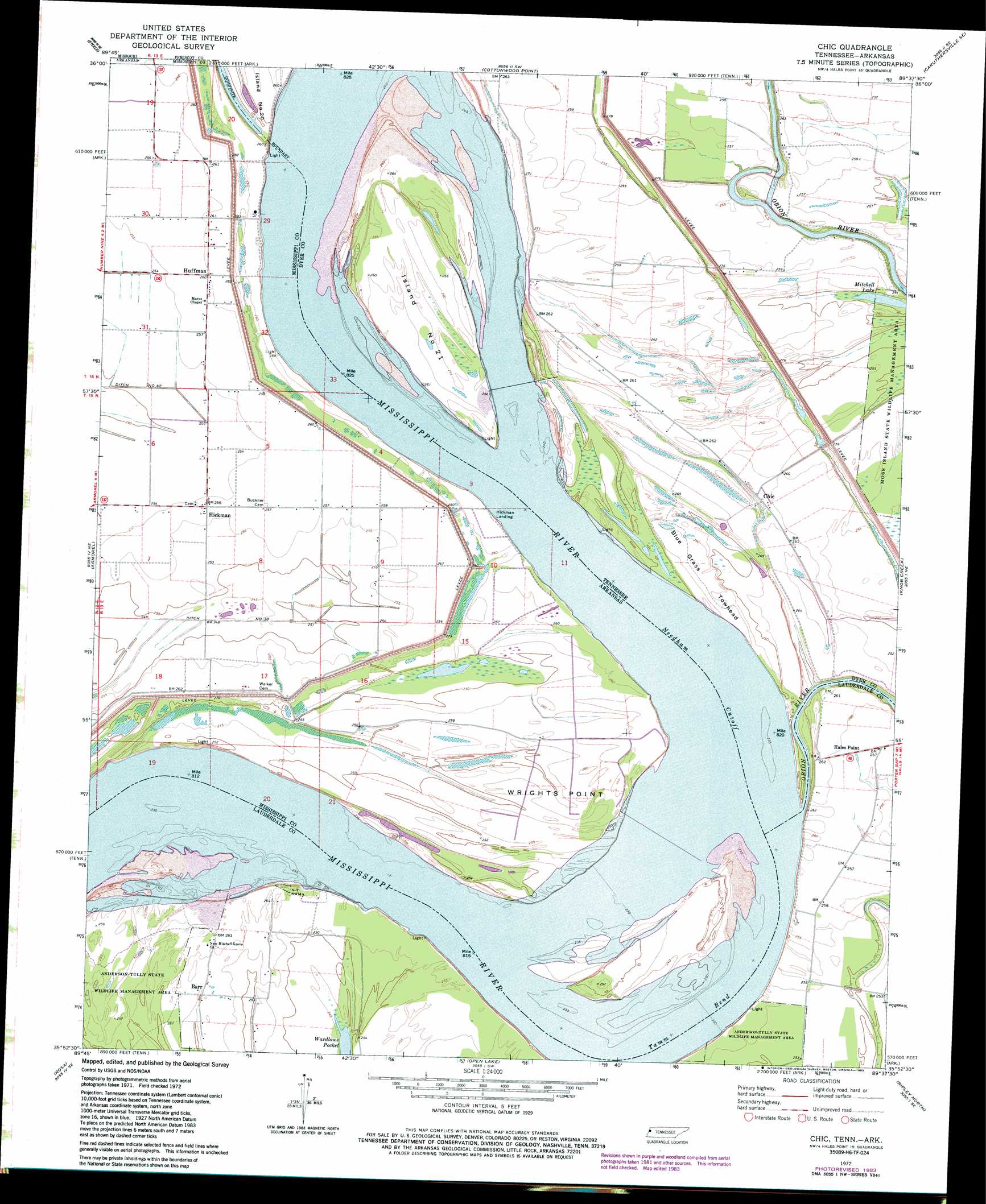
USGS Topo Quad 35089h6 - 1:24,000 scale
| Topo Map Name: | Chic |
| USGS Topo Quad ID: | 35089h6 |
| Print Size: | ca. 21 1/4" wide x 27" high |
| Southeast Coordinates: | 35.875° N latitude / 89.625° W longitude |
| Map Center Coordinates: | 35.9375° N latitude / 89.6875° W longitude |
| U.S. States: | TN, AR |
| Filename: | o35089h6.jpg |
| Download Map JPG Image: | Chic topo map 1:24,000 scale |
| Map Type: | Topographic |
| Topo Series: | 7.5´ |
| Map Scale: | 1:24,000 |
| Source of Map Images: | United States Geological Survey (USGS) |
| Alternate Map Versions: |
Chic TN 1972, updated 1975 Download PDF Buy paper map Chic TN 1972, updated 1983 Download PDF Buy paper map Chic TN 2011 Download PDF Buy paper map Chic TN 2013 Download PDF Buy paper map Chic TN 2016 Download PDF Buy paper map |
1:24,000 Topo Quads surrounding Chic
Deering |
Hayti Heights |
Caruthersville |
Tennemo |
Miston |
Denton |
Steele |
Cottonwood Point |
Caruthersville Se |
Dyersburg |
Blytheville |
Armorel |
Chic |
Knob Creek |
Fowlkes |
Luxora |
Rosa |
Open Lake |
Ripley North |
Gates |
Osceola |
Golddust |
Fort Pillow |
Ripley South |
Durhamville |
> Back to 35089e1 at 1:100,000 scale
> Back to 35088a1 at 1:250,000 scale
> Back to U.S. Topo Maps home
Chic topo map: Gazetteer
Chic: Bars
Barfield Bar elevation 70m 229′Chic: Bends
Needham Cutoff elevation 74m 242′Tamm Bend elevation 71m 232′
Chic: Canals
Ditch Number 38 elevation 76m 249′Chic: Capes
Wrights Point elevation 76m 249′Chic: Channels
Island Number Twentyone Chute elevation 71m 232′Chic: Flats
Blue Grass Towhead elevation 80m 262′Chic: Islands
Island Number Twenty-one elevation 78m 255′Chic: Lakes
Mitchell Lake elevation 75m 246′Chic: Levees
Below Tamm Bend Dikes elevation 74m 242′Hickman Revetment elevation 75m 246′
Island Number Twentyone Chute Dike elevation 71m 232′
Wrights Point Dikes (historical) elevation 74m 242′
Chic: Populated Places
Barr elevation 78m 255′Chic elevation 79m 259′
Hales Point elevation 78m 255′
Hickman elevation 80m 262′
Hickman Landing elevation 75m 246′
Huffman elevation 79m 259′
Michell (historical) elevation 84m 275′
Chic: Streams
Obion River elevation 71m 232′Chic digital topo map on disk
Buy this Chic topo map showing relief, roads, GPS coordinates and other geographical features, as a high-resolution digital map file on DVD: