Edmondson Topo Map Arkansas
To zoom in, hover over the map of Edmondson
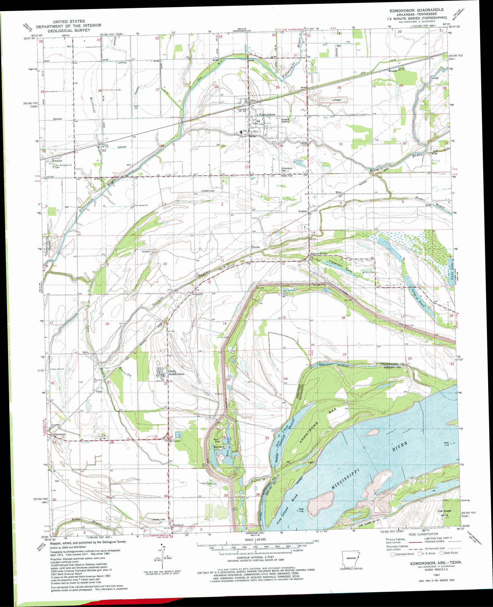
USGS Topo Quad 35090a3 - 1:24,000 scale
| Topo Map Name: | Edmondson |
| USGS Topo Quad ID: | 35090a3 |
| Print Size: | ca. 21 1/4" wide x 27" high |
| Southeast Coordinates: | 35° N latitude / 90.25° W longitude |
| Map Center Coordinates: | 35.0625° N latitude / 90.3125° W longitude |
| U.S. States: | AR, TN |
| Filename: | o35090a3.jpg |
| Download Map JPG Image: | Edmondson topo map 1:24,000 scale |
| Map Type: | Topographic |
| Topo Series: | 7.5´ |
| Map Scale: | 1:24,000 |
| Source of Map Images: | United States Geological Survey (USGS) |
| Alternate Map Versions: |
Edmondson SE AR 1975, updated 1976 Download PDF Buy paper map Edmondson AR 1981, updated 1982 Download PDF Buy paper map Edmondson AR 2011 Download PDF Buy paper map Edmondson AR 2014 Download PDF Buy paper map |
1:24,000 Topo Quads surrounding Edmondson
Parkin |
Earle |
Heafer |
Jericho |
Locke |
Gieseck |
Jeanette |
Crawfordsville |
West Memphis |
Northwest Memphis |
Round Pond |
Chatfield |
Edmondson |
Fletcher Lake |
Southwest Memphis |
Mud Lake |
Hughes |
Horseshoe Lake |
Lake Cormorant |
Horn Lake |
Brickeys |
Council |
Robinsonville |
Banks |
Frees Corners |
> Back to 35090a1 at 1:100,000 scale
> Back to 35090a1 at 1:250,000 scale
> Back to U.S. Topo Maps home
Edmondson topo map: Gazetteer
Edmondson: Bends
Cow Island Bend elevation 58m 190′Edmondson: Canals
Ditch Number 12 elevation 60m 196′Edmondson: Dams
Swan Lake Dam elevation 62m 203′Edmondson: Guts
Blue Lake elevation 58m 190′Graves Bayou elevation 61m 200′
Edmondson: Lakes
Long Pond elevation 60m 196′Swan Lake elevation 62m 203′
Edmondson: Populated Places
Anthony Subdivision elevation 62m 203′Anthonyville elevation 61m 200′
Brice elevation 65m 213′
Edmondson elevation 63m 206′
Kate elevation 64m 209′
Louise elevation 65m 213′
Midway Corner elevation 63m 206′
Mounds elevation 64m 209′
Neuhardt elevation 67m 219′
Ninetysix Corner elevation 60m 196′
Patoka elevation 64m 209′
Proctor elevation 63m 206′
Simsboro elevation 62m 203′
Thompson elevation 61m 200′
Topaz elevation 63m 206′
Edmondson: Streams
Beaver Slu elevation 59m 193′Cut-off Bayou elevation 64m 209′
Decker Bayou elevation 64m 209′
Lost Creek elevation 63m 206′
Tenmile Bayou elevation 63m 206′
Twentymile Bayou elevation 64m 209′
Warehouse Bayou elevation 61m 200′
Edmondson: Swamps
Copperas Lake elevation 62m 203′Edmondson digital topo map on disk
Buy this Edmondson topo map showing relief, roads, GPS coordinates and other geographical features, as a high-resolution digital map file on DVD: