Forrest City Topo Map Arkansas
To zoom in, hover over the map of Forrest City
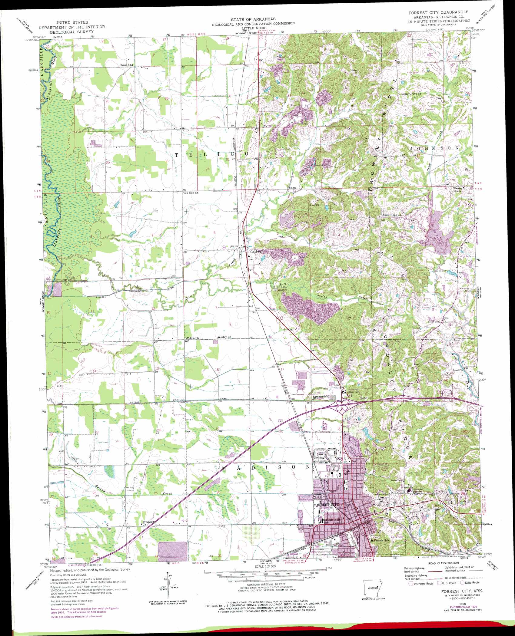
USGS Topo Quad 35090a7 - 1:24,000 scale
| Topo Map Name: | Forrest City |
| USGS Topo Quad ID: | 35090a7 |
| Print Size: | ca. 21 1/4" wide x 27" high |
| Southeast Coordinates: | 35° N latitude / 90.75° W longitude |
| Map Center Coordinates: | 35.0625° N latitude / 90.8125° W longitude |
| U.S. State: | AR |
| Filename: | o35090a7.jpg |
| Download Map JPG Image: | Forrest City topo map 1:24,000 scale |
| Map Type: | Topographic |
| Topo Series: | 7.5´ |
| Map Scale: | 1:24,000 |
| Source of Map Images: | United States Geological Survey (USGS) |
| Alternate Map Versions: |
Forrest City AR 1958, updated 1959 Download PDF Buy paper map Forrest City AR 1958, updated 1977 Download PDF Buy paper map Forrest City AR 2011 Download PDF Buy paper map Forrest City AR 2014 Download PDF Buy paper map |
1:24,000 Topo Quads surrounding Forrest City
Tilton |
Central |
Vanndale |
Princedale |
Parkin |
Fair Oaks |
Hamlin |
Wynne |
Wittsburg |
Gieseck |
Hunter East |
Hawkins |
Forrest City |
Madison |
Round Pond |
Wheatley |
Palestine |
Haynes |
Dansby |
Mud Lake |
Garrett Grove |
Moro |
Marianna |
Soudan |
Brickeys |
> Back to 35090a1 at 1:100,000 scale
> Back to 35090a1 at 1:250,000 scale
> Back to U.S. Topo Maps home
Forrest City topo map: Gazetteer
Forrest City: Airports
Baptist Memorial Hospital-FC Heliport elevation 101m 331′Forrest City: Canals
Lindsey Drainage Ditch elevation 64m 209′Spybuck Drainage Canal elevation 66m 216′
Forrest City: Crossings
Interchange 241 elevation 83m 272′Interchange 242 elevation 99m 324′
Forrest City: Dams
Forest Lake Number 3 Dam elevation 89m 291′Forest Lake Number 5 Dam elevation 104m 341′
Forest Lake Number 6 Dam elevation 104m 341′
Hickey Lake Dam elevation 92m 301′
Lake Saint Francis Dam elevation 97m 318′
Telico Lake Dam elevation 83m 272′
Forrest City: Parks
Beech Grove Park elevation 78m 255′Northside Park elevation 80m 262′
Smith Stadium elevation 76m 249′
Stuart Springs Park elevation 99m 324′
Forrest City: Populated Places
Caldwell elevation 73m 239′Forrest City elevation 79m 259′
Harris elevation 96m 314′
Meadow Cliff elevation 105m 344′
Mount Vernon (historical) elevation 80m 262′
Rosine elevation 73m 239′
Shiloh elevation 66m 216′
Telico (historical) elevation 65m 213′
Union Hill elevation 75m 246′
Forrest City: Post Offices
Forrest City Post Office elevation 91m 298′Forrest City: Reservoirs
Forest Lake Number 3 elevation 89m 291′Forest Lake Number 5 elevation 104m 341′
Forest Lake Number 6 elevation 104m 341′
Hickey Lake elevation 92m 301′
Lake Saint Francis elevation 97m 318′
Telico Lake elevation 83m 272′
Forrest City: Ridges
Crowley Ridge elevation 105m 344′Forrest City: Streams
Big Telico Creek elevation 63m 206′Griggs Creek elevation 97m 318′
Little Telico Creek elevation 71m 232′
Forrest City digital topo map on disk
Buy this Forrest City topo map showing relief, roads, GPS coordinates and other geographical features, as a high-resolution digital map file on DVD: