Heafer Topo Map Arkansas
To zoom in, hover over the map of Heafer
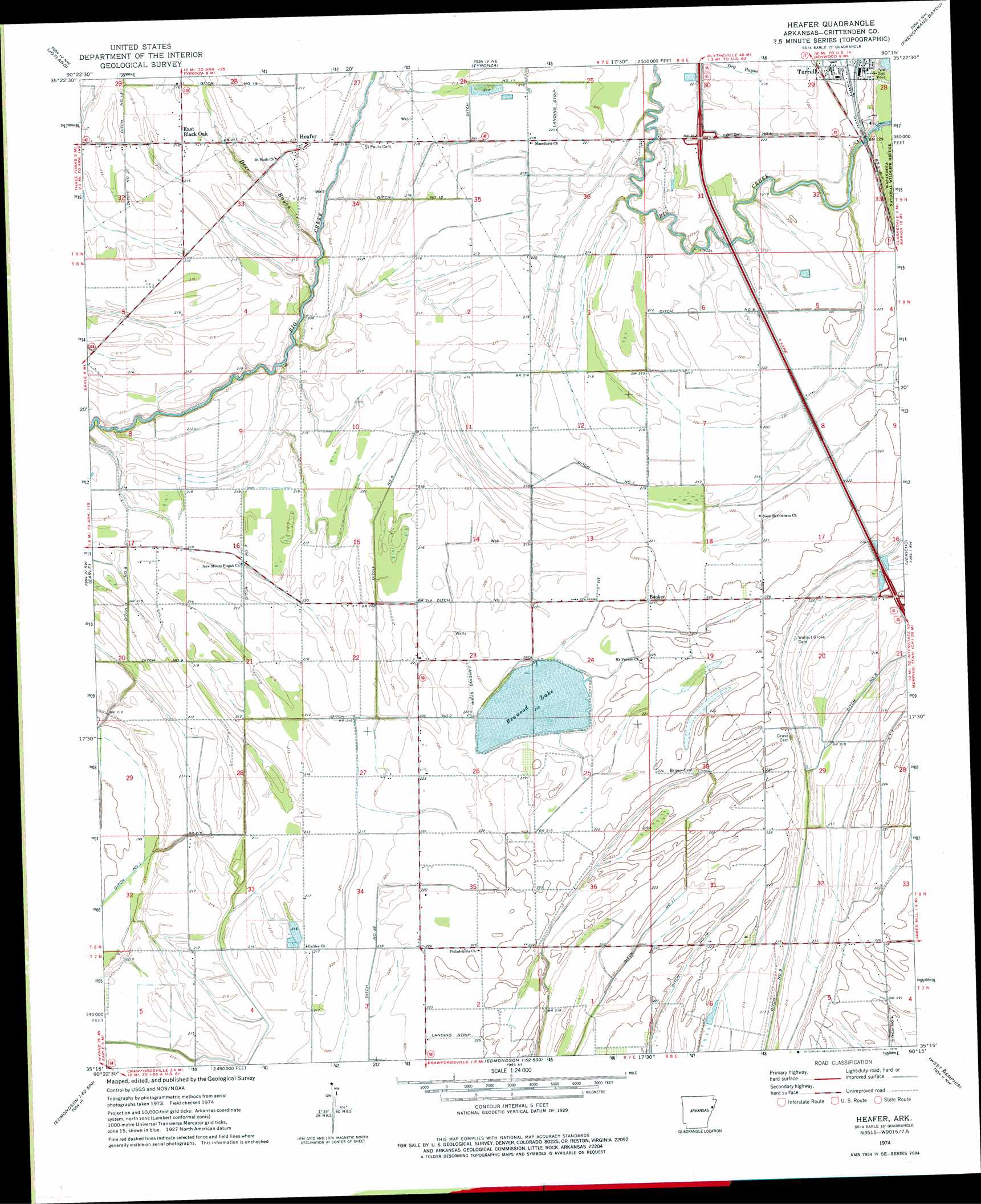
USGS Topo Quad 35090c3 - 1:24,000 scale
| Topo Map Name: | Heafer |
| USGS Topo Quad ID: | 35090c3 |
| Print Size: | ca. 21 1/4" wide x 27" high |
| Southeast Coordinates: | 35.25° N latitude / 90.25° W longitude |
| Map Center Coordinates: | 35.3125° N latitude / 90.3125° W longitude |
| U.S. State: | AR |
| Filename: | o35090c3.jpg |
| Download Map JPG Image: | Heafer topo map 1:24,000 scale |
| Map Type: | Topographic |
| Topo Series: | 7.5´ |
| Map Scale: | 1:24,000 |
| Source of Map Images: | United States Geological Survey (USGS) |
| Alternate Map Versions: |
Heafer AR 1963, updated 1976 Download PDF Buy paper map Heafer AR 2011 Download PDF Buy paper map Heafer AR 2014 Download PDF Buy paper map |
1:24,000 Topo Quads surrounding Heafer
Mccormick |
Marked Tree |
Lepanto |
Joiner |
Wilson |
Monterey |
Joyland |
Tyronza |
Frenchmans Bayou |
Pecan Point |
Parkin |
Earle |
Heafer |
Jericho |
Locke |
Gieseck |
Jeanette |
Crawfordsville |
West Memphis |
Northwest Memphis |
Round Pond |
Chatfield |
Edmondson |
Fletcher Lake |
Southwest Memphis |
> Back to 35090a1 at 1:100,000 scale
> Back to 35090a1 at 1:250,000 scale
> Back to U.S. Topo Maps home
Heafer topo map: Gazetteer
Heafer: Canals
Ditch Number 1 elevation 67m 219′Ditch Number 10 elevation 66m 216′
Ditch Number 11 elevation 64m 209′
Ditch Number 11 elevation 64m 209′
Ditch Number 2 elevation 68m 223′
Ditch Number 21 elevation 64m 209′
Ditch Number 32 elevation 65m 213′
Ditch Number 4 elevation 68m 223′
Ditch Number 6 elevation 66m 216′
Ditch Number 7 elevation 64m 209′
Ditch Number 8 elevation 65m 213′
Heafer: Crossings
Interchange 17 elevation 70m 229′Interchange 21 elevation 68m 223′
Heafer: Lakes
Benwood Lake elevation 64m 209′Heafer: Populated Places
Booker elevation 67m 219′Heafer elevation 67m 219′
Heafer: Streams
Deer Bayou elevation 61m 200′Heafer digital topo map on disk
Buy this Heafer topo map showing relief, roads, GPS coordinates and other geographical features, as a high-resolution digital map file on DVD: