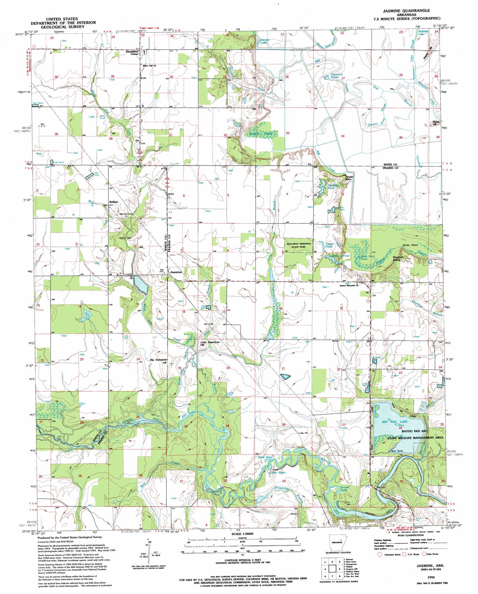
Jasmine Topo Map Arkansas
To zoom in, hover over the map of Jasmine
USGS Topo Quad 35091a5 - 1:24,000 scale
| Topo Map Name: | Jasmine |
| USGS Topo Quad ID: | 35091a5 |
| Print Size: | ca. 21 1/4" wide x 27" high |
| Southeast Coordinates: | 35° N latitude / 91.5° W longitude |
| Map Center Coordinates: | 35.0625° N latitude / 91.5625° W longitude |
| U.S. State: | AR |
| Filename: | o35091a5.jpg |
| Download Map JPG Image: | Jasmine topo map 1:24,000 scale |
| Map Type: | Topographic |
| Topo Series: | 7.5´ |
| Map Scale: | 1:24,000 |
| Source of Map Images: | United States Geological Survey (USGS) |
| Alternate Map Versions: |
Jasmine AR 1964, updated 1965 Download PDF Buy paper map Jasmine AR 1994, updated 1994 Download PDF Buy paper map Jasmine AR 2011 Download PDF Buy paper map Jasmine AR 2014 Download PDF Buy paper map |
1:24,000 Topo Quads surrounding Jasmine
Letona |
Judsonia |
Bald Knob |
Augusta Sw |
Augusta |
Garner |
Kensett |
West Point |
Georgetown |
Gregory |
Mcrae |
Walker |
Jasmine |
Gregory Sw |
Cotton Plant |
Wattensaw |
Hickory Plains |
Des Arc West |
Des Arc East |
De Valls Bluff Ne |
Pocket Prarie |
Carlisle |
Hazen |
De Valls Bluff |
De Valls Bluff Se |
> Back to 35091a1 at 1:100,000 scale
> Back to 35090a1 at 1:250,000 scale
> Back to U.S. Topo Maps home
Jasmine topo map: Gazetteer
Jasmine: Cliffs
Dicks Point elevation 63m 206′Fowler Point elevation 58m 190′
Jasmine: Dams
Keathley Pond Dam elevation 62m 203′Lake Des Arc Dam elevation 60m 196′
Jasmine: Lakes
Blind Basin elevation 51m 167′Blue Hole (historical) elevation 55m 180′
Browns Pond (historical) elevation 57m 187′
Coitier Basin elevation 54m 177′
Crow Lake (historical) elevation 57m 187′
Diamond Pond elevation 55m 180′
Goose Basin elevation 48m 157′
Jarvers Lake elevation 57m 187′
Keathley Pond elevation 62m 203′
Little Gum Pond elevation 58m 190′
McGhee Lake (historical) elevation 57m 187′
Round Basin elevation 52m 170′
Wheaton Lake elevation 54m 177′
Jasmine: Parks
Holloway Memorial State Park elevation 65m 213′Jasmine: Populated Places
Belcher elevation 64m 209′Enarc (historical) elevation 57m 187′
Hicksville (historical) elevation 65m 213′
Hunterton (historical) elevation 59m 193′
Jasmine elevation 62m 203′
Showalters Corner elevation 64m 209′
Stineville (historical) elevation 59m 193′
Willard (historical) elevation 59m 193′
Jasmine: Reservoirs
Holloway Pond elevation 62m 203′Lake Des Arc elevation 60m 196′
Taylor Pond elevation 64m 209′
Jasmine: Streams
Bear Creek elevation 54m 177′Beaver Pond Slough elevation 56m 183′
Brownings Branch elevation 54m 177′
Browns Pond Slough elevation 55m 180′
Crooked Creek elevation 57m 187′
Darst Branch elevation 57m 187′
East Branch Raft Creek elevation 54m 177′
Long Branch elevation 55m 180′
Overflow Branch elevation 51m 167′
Redman Lake Slough elevation 55m 180′
White Oak Creek elevation 55m 180′
Jasmine: Summits
Big Greenbrier Hill elevation 59m 193′Hacks Hill elevation 59m 193′
Little Greenbrier Hill elevation 61m 200′
Rafes Hill elevation 60m 196′
Jasmine: Swamps
Bevel Brake elevation 58m 190′Big Gum Pond (historical) elevation 56m 183′
Clemens Brake (historical) elevation 58m 190′
Eagle Brake elevation 55m 180′
Gum Brake (historical) elevation 57m 187′
Rayburn Brake elevation 57m 187′
Round Brake (historical) elevation 56m 183′
Watkins Brake elevation 57m 187′
Jasmine digital topo map on disk
Buy this Jasmine topo map showing relief, roads, GPS coordinates and other geographical features, as a high-resolution digital map file on DVD: