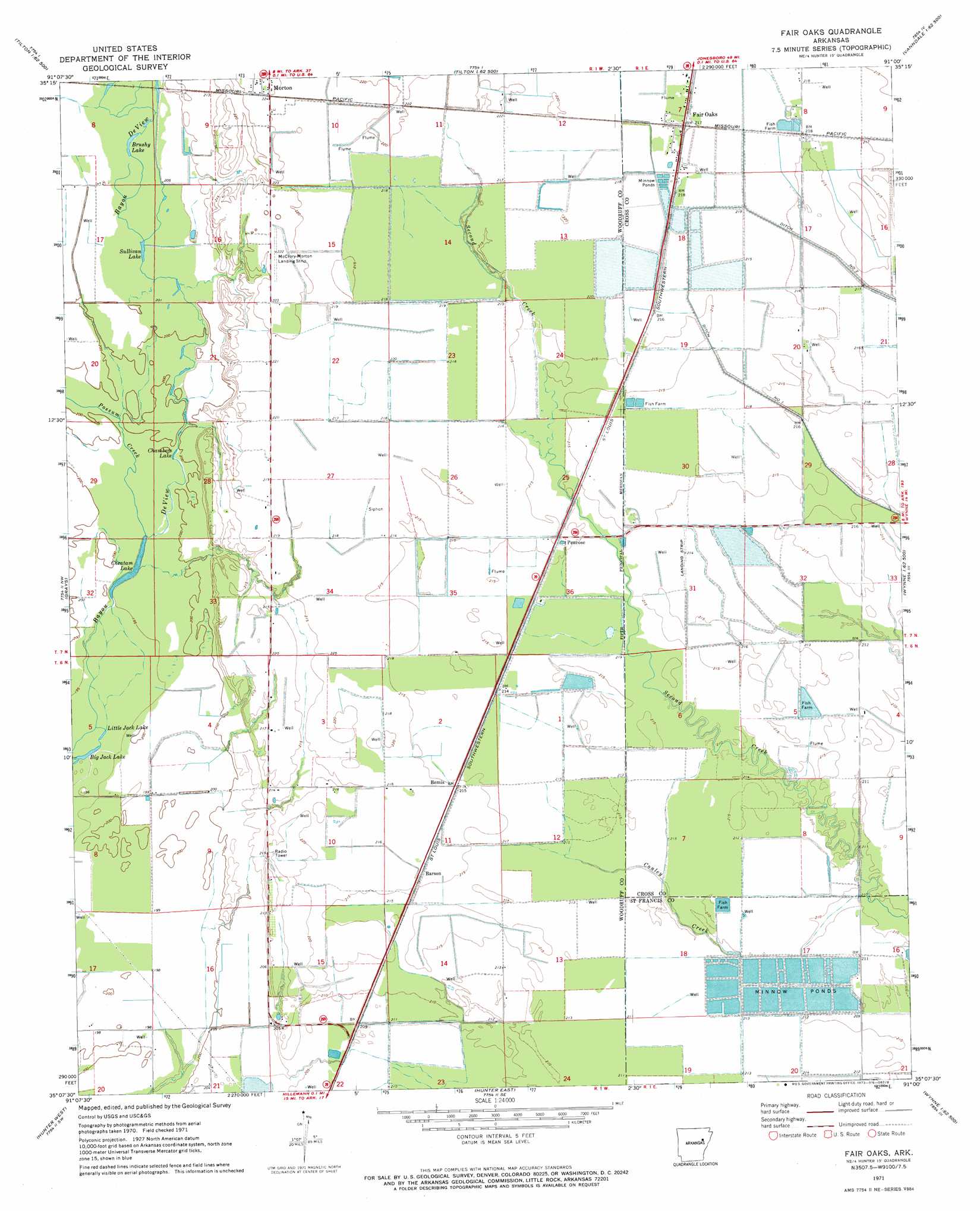
Fair Oaks Topo Map Arkansas
To zoom in, hover over the map of Fair Oaks
USGS Topo Quad 35091b1 - 1:24,000 scale
| Topo Map Name: | Fair Oaks |
| USGS Topo Quad ID: | 35091b1 |
| Print Size: | ca. 21 1/4" wide x 27" high |
| Southeast Coordinates: | 35.125° N latitude / 91° W longitude |
| Map Center Coordinates: | 35.1875° N latitude / 91.0625° W longitude |
| U.S. State: | AR |
| Filename: | o35091b1.jpg |
| Download Map JPG Image: | Fair Oaks topo map 1:24,000 scale |
| Map Type: | Topographic |
| Topo Series: | 7.5´ |
| Map Scale: | 1:24,000 |
| Source of Map Images: | United States Geological Survey (USGS) |
| Alternate Map Versions: |
Fair Oaks AR 1971, updated 1973 Download PDF Buy paper map Fair Oaks AR 2011 Download PDF Buy paper map Fair Oaks AR 2014 Download PDF Buy paper map |
1:24,000 Topo Quads surrounding Fair Oaks
Augusta Ne |
Tupelo |
Beedeville |
Hickory Ridge |
Cherry Valley West |
Augusta |
Mccrory |
Tilton |
Central |
Vanndale |
Gregory |
Grays |
Fair Oaks |
Hamlin |
Wynne |
Cotton Plant |
Hunter West |
Hunter East |
Hawkins |
Forrest City |
De Valls Bluff Ne |
Brinkley |
Wheatley |
Palestine |
Haynes |
> Back to 35091a1 at 1:100,000 scale
> Back to 35090a1 at 1:250,000 scale
> Back to U.S. Topo Maps home
Fair Oaks topo map: Gazetteer
Fair Oaks: Airports
McCrory-Morton Airport elevation 69m 226′Penrose Airport elevation 65m 213′
Fair Oaks: Canals
Ditch Number 1 elevation 67m 219′Ditch Number 2 elevation 68m 223′
Fair Oaks: Lakes
Big Jack Lake elevation 61m 200′Brushy Lake elevation 63m 206′
Chambers Lake elevation 62m 203′
Cheatam Lake elevation 61m 200′
Little Jack Lake elevation 61m 200′
Sullivan Lake elevation 64m 209′
Fair Oaks: Populated Places
Barson elevation 68m 223′Bemis elevation 68m 223′
Fair Oaks elevation 67m 219′
Penrose elevation 66m 216′
Fair Oaks: Streams
Conley Creek elevation 65m 213′Possum Creek elevation 62m 203′
Fair Oaks digital topo map on disk
Buy this Fair Oaks topo map showing relief, roads, GPS coordinates and other geographical features, as a high-resolution digital map file on DVD: