Steprock Topo Map Arkansas
To zoom in, hover over the map of Steprock
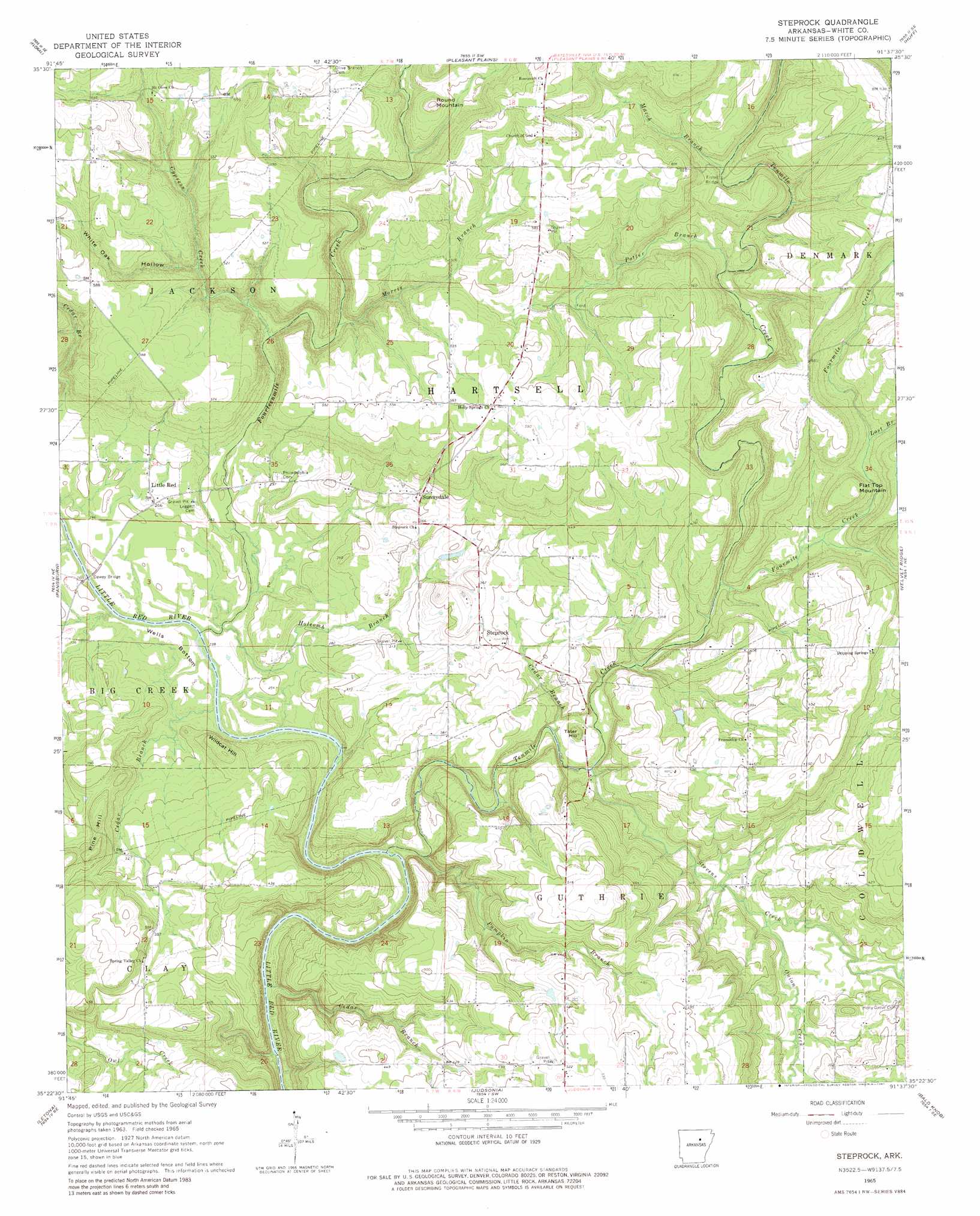
USGS Topo Quad 35091d6 - 1:24,000 scale
| Topo Map Name: | Steprock |
| USGS Topo Quad ID: | 35091d6 |
| Print Size: | ca. 21 1/4" wide x 27" high |
| Southeast Coordinates: | 35.375° N latitude / 91.625° W longitude |
| Map Center Coordinates: | 35.4375° N latitude / 91.6875° W longitude |
| U.S. State: | AR |
| Filename: | o35091d6.jpg |
| Download Map JPG Image: | Steprock topo map 1:24,000 scale |
| Map Type: | Topographic |
| Topo Series: | 7.5´ |
| Map Scale: | 1:24,000 |
| Source of Map Images: | United States Geological Survey (USGS) |
| Alternate Map Versions: |
Steprock AR 1965, updated 1966 Download PDF Buy paper map Steprock AR 1965, updated 1981 Download PDF Buy paper map Steprock AR 2011 Download PDF Buy paper map Steprock AR 2014 Download PDF Buy paper map |
1:24,000 Topo Quads surrounding Steprock
Drasco |
Concord |
Jamestown |
Salado |
Newark |
Greers Ferry Dam |
Floral |
Pleasant Plains |
Huff |
Olyphant |
West Pangburn |
Pangburn |
Steprock |
Velvet Ridge |
Bradford |
Sidon |
Letona |
Judsonia |
Bald Knob |
Augusta Sw |
Floyd |
Garner |
Kensett |
West Point |
Georgetown |
> Back to 35091a1 at 1:100,000 scale
> Back to 35090a1 at 1:250,000 scale
> Back to U.S. Topo Maps home
Steprock topo map: Gazetteer
Steprock: Bends
Wells Bottom elevation 69m 226′Steprock: Bridges
Dewey Bridge elevation 77m 252′Fisher Bridge elevation 129m 423′
Steprock: Dams
Bridges Lake Dam elevation 108m 354′Chavell Lake Two Dam elevation 152m 498′
Hill Lake Dam elevation 137m 449′
Steprock: Populated Places
Bare Stone elevation 133m 436′Davenport (historical) elevation 179m 587′
Doyleville (historical) elevation 182m 597′
Little Red elevation 80m 262′
Maddock (historical) elevation 178m 583′
Steprock elevation 104m 341′
Sunnydale elevation 113m 370′
Steprock: Post Offices
Steprock Post Office elevation 110m 360′Steprock: Reservoirs
Bridges Lake elevation 108m 354′Chavell Lake Two elevation 152m 498′
Hill Lake elevation 137m 449′
Steprock: Streams
Cedar Branch elevation 77m 252′Cedar Branch elevation 71m 232′
Cedar Branch elevation 64m 209′
Cypress Creek elevation 94m 308′
Fourmile Creek elevation 87m 285′
Fourteenmile Creek elevation 65m 213′
Holcomb Branch elevation 69m 226′
Lost Branch elevation 118m 387′
March Branch elevation 130m 426′
Morris Branch elevation 119m 390′
Onion Creek elevation 83m 272′
Potter Branch elevation 114m 374′
Pumpkin Branch elevation 74m 242′
Stevens Creek elevation 80m 262′
Tenmile Creek elevation 62m 203′
Steprock: Summits
Flat Top Mountain elevation 167m 547′Pine Hill elevation 134m 439′
Round Mountain elevation 191m 626′
Tater Hill elevation 100m 328′
Wildcat Hill elevation 123m 403′
Steprock: Valleys
White Oak Hollow elevation 131m 429′Steprock digital topo map on disk
Buy this Steprock topo map showing relief, roads, GPS coordinates and other geographical features, as a high-resolution digital map file on DVD: