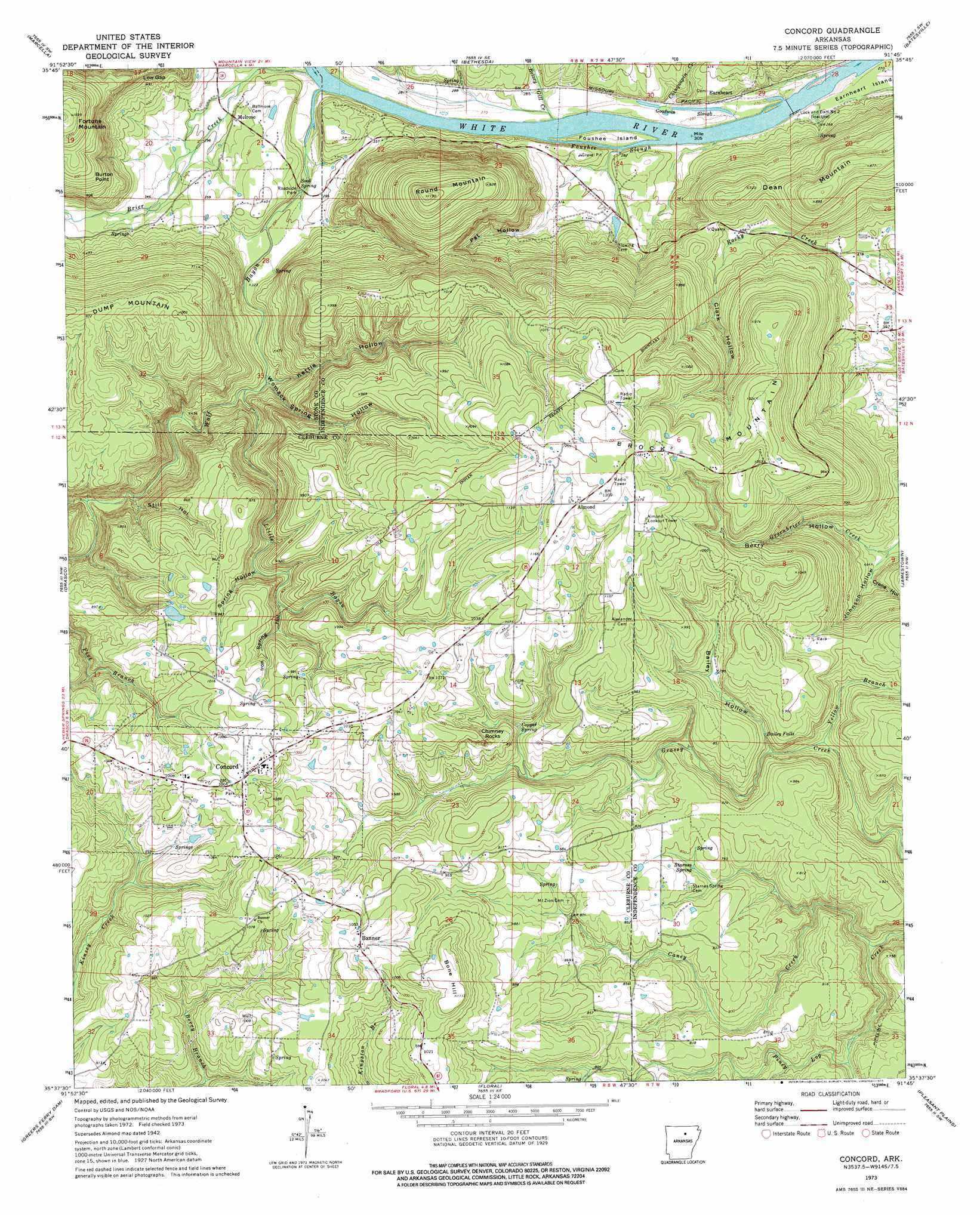
Concord Topo Map Arkansas
To zoom in, hover over the map of Concord
USGS Topo Quad 35091f7 - 1:24,000 scale
| Topo Map Name: | Concord |
| USGS Topo Quad ID: | 35091f7 |
| Print Size: | ca. 21 1/4" wide x 27" high |
| Southeast Coordinates: | 35.625° N latitude / 91.75° W longitude |
| Map Center Coordinates: | 35.6875° N latitude / 91.8125° W longitude |
| U.S. State: | AR |
| Filename: | o35091f7.jpg |
| Download Map JPG Image: | Concord topo map 1:24,000 scale |
| Map Type: | Topographic |
| Topo Series: | 7.5´ |
| Map Scale: | 1:24,000 |
| Source of Map Images: | United States Geological Survey (USGS) |
| Alternate Map Versions: |
Almond AR 1942, updated 1956 Download PDF Buy paper map Concord AR 1973, updated 1975 Download PDF Buy paper map Concord AR 2011 Download PDF Buy paper map Concord AR 2014 Download PDF Buy paper map |
1:24,000 Topo Quads surrounding Concord
Sylamore |
Guion |
Mount Pleasant |
Sandtown |
Cave City |
Mountain View |
Marcella |
Bethesda |
Batesville |
Sulphur Rock |
Prim |
Drasco |
Concord |
Jamestown |
Salado |
Brownsville |
Greers Ferry Dam |
Floral |
Pleasant Plains |
Huff |
Heber Springs |
West Pangburn |
Pangburn |
Steprock |
Velvet Ridge |
> Back to 35091e1 at 1:100,000 scale
> Back to 35090a1 at 1:250,000 scale
> Back to U.S. Topo Maps home
Concord topo map: Gazetteer
Concord: Capes
Burton Point elevation 231m 757′Concord: Dams
Bullard Lake Dam elevation 278m 912′Lock and Dam Number 2 elevation 75m 246′
Concord: Falls
Bailey Falls elevation 218m 715′Concord: Gaps
Low Gap elevation 188m 616′Concord: Islands
Foushee Island elevation 79m 259′Concord: Pillars
Chimney Rocks elevation 292m 958′Concord: Populated Places
Almond elevation 361m 1184′Banner elevation 326m 1069′
Concord elevation 317m 1040′
Earnheart elevation 86m 282′
Melrose elevation 91m 298′
Concord: Post Offices
Starnes Springs Post Office (historical) elevation 241m 790′Concord: Reservoirs
Bullard Lake elevation 278m 912′Concord: Springs
Copper Spring elevation 256m 839′Sook Spring elevation 89m 291′
Starnes Spring elevation 234m 767′
Concord: Streams
Betsey Gill Creek elevation 78m 255′Brier Creek elevation 80m 262′
Caney Creek elevation 174m 570′
Chinquapin Creek elevation 80m 262′
Foushee Slough elevation 77m 252′
Goodwin Slough elevation 80m 262′
Little Bayou elevation 110m 360′
Wolf Bayou elevation 80m 262′
Yellow Branch elevation 185m 606′
Concord: Summits
Bone Hill elevation 342m 1122′Brock Mountain elevation 366m 1200′
Dean Mountain elevation 262m 859′
Round Mountain elevation 345m 1131′
Concord: Valleys
Bailey Hollow elevation 194m 636′Berry Hollow elevation 129m 423′
Clark Hollow elevation 117m 383′
Crane Hollow elevation 137m 449′
Iron Spring Hollow elevation 239m 784′
Johnson Hollow elevation 129m 423′
Kettle Hollow elevation 108m 354′
Pat Hollow elevation 80m 262′
Spring Hollow elevation 226m 741′
Still Hollow elevation 149m 488′
Womack Spring Hollow elevation 108m 354′
Concord digital topo map on disk
Buy this Concord topo map showing relief, roads, GPS coordinates and other geographical features, as a high-resolution digital map file on DVD: