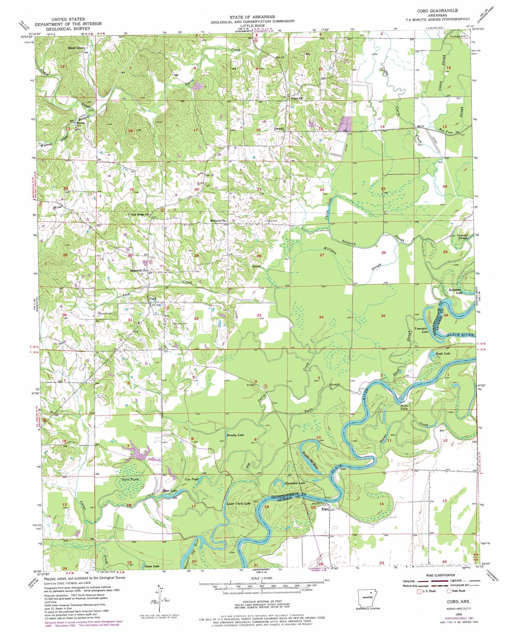
Cord Topo Map Arkansas
To zoom in, hover over the map of Cord
USGS Topo Quad 35091g3 - 1:24,000 scale
| Topo Map Name: | Cord |
| USGS Topo Quad ID: | 35091g3 |
| Print Size: | ca. 21 1/4" wide x 27" high |
| Southeast Coordinates: | 35.75° N latitude / 91.25° W longitude |
| Map Center Coordinates: | 35.8125° N latitude / 91.3125° W longitude |
| U.S. State: | AR |
| Filename: | o35091g3.jpg |
| Download Map JPG Image: | Cord topo map 1:24,000 scale |
| Map Type: | Topographic |
| Topo Series: | 7.5´ |
| Map Scale: | 1:24,000 |
| Source of Map Images: | United States Geological Survey (USGS) |
| Alternate Map Versions: |
Cord AR 1955, updated 1956 Download PDF Buy paper map Cord AR 1955, updated 1956 Download PDF Buy paper map Cord AR 1955, updated 1982 Download PDF Buy paper map Cord AR 2011 Download PDF Buy paper map Cord AR 2014 Download PDF Buy paper map |
1:24,000 Topo Quads surrounding Cord
Evening Shade |
Poughkeepsie |
Smithville |
Eaton |
Black Rock |
Cave City |
Grange |
Strawberry |
Strangers Home |
Alicia |
Sulphur Rock |
Charlotte |
Cord |
Swifton West |
Swifton East |
Salado |
Newark |
Jacksonport |
Tuckerman |
Grubbs |
Huff |
Olyphant |
Newport |
Auvergne |
Amagon |
> Back to 35091e1 at 1:100,000 scale
> Back to 35090a1 at 1:250,000 scale
> Back to U.S. Topo Maps home
Cord topo map: Gazetteer
Cord: Bays
Hobbs Eddy elevation 66m 216′Cord: Guts
Bee Tree Slough elevation 69m 226′Milligan Slough elevation 68m 223′
Saltwork Slough elevation 65m 213′
Swift Slough elevation 67m 219′
Cord: Lakes
Brushy Lake elevation 66m 216′Cow Pond elevation 66m 216′
Curia Lake elevation 68m 223′
Eagle Lake elevation 65m 213′
Goose Lake elevation 67m 219′
Horseshoe Lake elevation 64m 209′
Lower Curia Lake elevation 61m 200′
Otter Lake elevation 65m 213′
Racetrack Lake elevation 67m 219′
Yoncopin Lake elevation 71m 232′
Cord: Populated Places
Cord elevation 103m 337′Dowdy elevation 96m 314′
Elgin elevation 69m 226′
Hazel Grove elevation 112m 367′
Cord: Post Offices
Cord Post Office elevation 98m 321′Cord: Streams
Burns Creek elevation 66m 216′Caney Slough elevation 68m 223′
Deep Slough elevation 68m 223′
Lick Creek elevation 70m 229′
Middle Old River elevation 64m 209′
Old Curia Creek elevation 64m 209′
Walnut Grove Branch elevation 84m 275′
Cord: Swamps
Steel Pond elevation 66m 216′Cord digital topo map on disk
Buy this Cord topo map showing relief, roads, GPS coordinates and other geographical features, as a high-resolution digital map file on DVD: