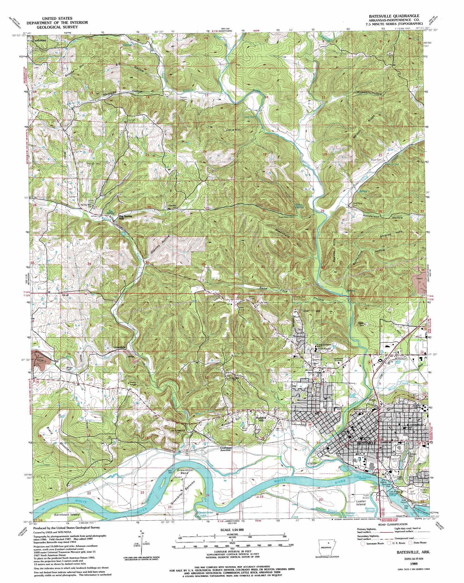
Batesville Topo Map Arkansas
To zoom in, hover over the map of Batesville
USGS Topo Quad 35091g6 - 1:24,000 scale
| Topo Map Name: | Batesville |
| USGS Topo Quad ID: | 35091g6 |
| Print Size: | ca. 21 1/4" wide x 27" high |
| Southeast Coordinates: | 35.75° N latitude / 91.625° W longitude |
| Map Center Coordinates: | 35.8125° N latitude / 91.6875° W longitude |
| U.S. State: | AR |
| Filename: | o35091g6.jpg |
| Download Map JPG Image: | Batesville topo map 1:24,000 scale |
| Map Type: | Topographic |
| Topo Series: | 7.5´ |
| Map Scale: | 1:24,000 |
| Source of Map Images: | United States Geological Survey (USGS) |
| Alternate Map Versions: |
Batesville AR 1943, updated 1956 Download PDF Buy paper map Batesville AR 1943, updated 1972 Download PDF Buy paper map Batesville AR 1943, updated 1978 Download PDF Buy paper map Batesville AR 1943, updated 1982 Download PDF Buy paper map Batesville AR 1989, updated 1989 Download PDF Buy paper map Batesville AR 2011 Download PDF Buy paper map Batesville AR 2014 Download PDF Buy paper map |
1:24,000 Topo Quads surrounding Batesville
Melbourne |
Zion |
Sidney |
Evening Shade |
Poughkeepsie |
Guion |
Mount Pleasant |
Sandtown |
Cave City |
Grange |
Marcella |
Bethesda |
Batesville |
Sulphur Rock |
Charlotte |
Drasco |
Concord |
Jamestown |
Salado |
Newark |
Greers Ferry Dam |
Floral |
Pleasant Plains |
Huff |
Olyphant |
> Back to 35091e1 at 1:100,000 scale
> Back to 35090a1 at 1:250,000 scale
> Back to U.S. Topo Maps home
Batesville topo map: Gazetteer
Batesville: Airports
White River Medical Center Heliport elevation 103m 337′Batesville: Crossings
Gainer Ferry (historical) elevation 73m 239′Greenbrier Ferry (historical) elevation 72m 236′
Ramsey Ferry (historical) elevation 72m 236′
Batesville: Dams
Lock 1 elevation 73m 239′Lock and Dam Number One elevation 63m 206′
Batesville: Flats
Greenbrier Bottoms elevation 79m 259′Batesville: Islands
Brush Island elevation 79m 259′Earnheart Island elevation 79m 259′
Luster Island elevation 77m 252′
Batesville: Lakes
Ruddell Lake elevation 75m 246′Batesville: Mines
A R Chin Prospect elevation 169m 554′Adler Mine elevation 157m 515′
Allen Mine elevation 101m 331′
Baxter Prospects elevation 167m 547′
Brooks Hill Mine elevation 216m 708′
Burge Mine elevation 143m 469′
Button Mine elevation 177m 580′
Cason Mine elevation 90m 295′
Cason Mine elevation 113m 370′
Champlain Prospect elevation 124m 406′
Climer Prospect elevation 145m 475′
Collins Prospect elevation 141m 462′
Criswell Prospect elevation 158m 518′
Deener Prospect elevation 160m 524′
Denison Mine elevation 126m 413′
Fortune Prospect elevation 182m 597′
Haigwood Prospect elevation 172m 564′
J B Thompson Prospect elevation 150m 492′
J W Greenfield Prospect elevation 115m 377′
John Patterson Prospect elevation 141m 462′
Kelley Prospect elevation 144m 472′
Marshall Mine elevation 112m 367′
Martha Thompson Mine elevation 168m 551′
Perrin Mine elevation 155m 508′
R T Patterson Mine elevation 124m 406′
Roberts Mine elevation 150m 492′
Rutherford Mine elevation 104m 341′
Scheid Quarry elevation 106m 347′
Shaw Mine elevation 170m 557′
Shell Mine elevation 204m 669′
Simmons Prospect elevation 95m 311′
W L Greenfield Mine elevation 110m 360′
W W Allen Mine elevation 146m 479′
Waco Prospect elevation 127m 416′
Walter Chinn Prospects elevation 149m 488′
Weaver-Dowdy Prospect elevation 114m 374′
Wildcat Mine elevation 183m 600′
Batesville: Parks
Batesville Commercial Historic District elevation 85m 278′Batesville East Main Historic District elevation 109m 357′
Batesville Water Carnival Stadium elevation 79m 259′
Daffin Field elevation 126m 413′
Fitzhugh Park elevation 100m 328′
Independence County Fairgrounds elevation 118m 387′
Kennedy Park elevation 77m 252′
Riverside Park elevation 79m 259′
Batesville: Populated Places
Batesville elevation 102m 334′Big Spring Mill elevation 125m 410′
Blowing Cave (historical) elevation 102m 334′
Cushman Junction elevation 80m 262′
Denieville (historical) elevation 106m 347′
Limedale elevation 99m 324′
Limedale Junction elevation 120m 393′
Meadow Heights elevation 157m 515′
Pattonville elevation 96m 314′
Pegg Addition elevation 86m 282′
Ruddell Hill elevation 143m 469′
Simmons elevation 109m 357′
Sun Valley Addition elevation 101m 331′
Batesville: Post Offices
Batesville Post Office elevation 96m 314′Batesville: Ranges
Reeves Hills elevation 180m 590′Shields Hills elevation 176m 577′
Batesville: Reservoirs
Lake Unico elevation 69m 226′Batesville: Ridges
Nelson Ridge elevation 217m 711′Batesville: Springs
Big Spring elevation 128m 419′Cave Spring elevation 87m 285′
Chinn Spring elevation 101m 331′
Stark Spring elevation 100m 328′
Batesville: Streams
Cave Creek elevation 89m 291′Dry Run elevation 95m 311′
Greenbrier Creek elevation 73m 239′
Miller Creek elevation 79m 259′
Poke Bayou elevation 73m 239′
Prairie Branch elevation 93m 305′
Simpson Slough elevation 74m 242′
Spring Creek elevation 76m 249′
Stillhouse Branch elevation 78m 255′
Sullivan Creek elevation 84m 275′
Wilson Branch elevation 91m 298′
Batesville: Summits
Baxter Hill elevation 187m 613′Bracy Mountain elevation 190m 623′
Brooks Hill elevation 246m 807′
Chris Hill elevation 186m 610′
Grapevine Hill elevation 138m 452′
Greenfield Hill elevation 184m 603′
Ruddell Hill elevation 160m 524′
Shaw Hill elevation 185m 606′
Shaw Hill elevation 185m 606′
Batesville: Valleys
Big Hollow elevation 108m 354′Bone Cave Hollow elevation 92m 301′
Grooms Hollow elevation 116m 380′
Henderson Hollow elevation 89m 291′
Mulligan Hollow elevation 106m 347′
Rutherford Hollow elevation 102m 334′
Wilson Hollow elevation 98m 321′
Batesville digital topo map on disk
Buy this Batesville topo map showing relief, roads, GPS coordinates and other geographical features, as a high-resolution digital map file on DVD: