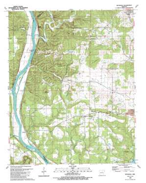
Bethesda Topo Map Arkansas
To zoom in, hover over the map of Bethesda
USGS Topo Quad 35091g7 - 1:24,000 scale
| Topo Map Name: | Bethesda |
| USGS Topo Quad ID: | 35091g7 |
| Print Size: | ca. 21 1/4" wide x 27" high |
| Southeast Coordinates: | 35.75° N latitude / 91.75° W longitude |
| Map Center Coordinates: | 35.8125° N latitude / 91.8125° W longitude |
| U.S. State: | AR |
| Filename: | o35091g7.jpg |
| Download Map JPG Image: | Bethesda topo map 1:24,000 scale |
| Map Type: | Topographic |
| Topo Series: | 7.5´ |
| Map Scale: | 1:24,000 |
| Source of Map Images: | United States Geological Survey (USGS) |
| Alternate Map Versions: |
Bethesda AR 1942 Download PDF Buy paper map Bethesda AR 1942, updated 1956 Download PDF Buy paper map Bethesda AR 1989, updated 1989 Download PDF Buy paper map Bethesda AR 2011 Download PDF Buy paper map Bethesda AR 2014 Download PDF Buy paper map |
1:24,000 Topo Quads surrounding Bethesda
> Back to 35091e1 at 1:100,000 scale
> Back to 35090a1 at 1:250,000 scale
> Back to U.S. Topo Maps home
Bethesda topo map: Gazetteer
Bethesda: Bars
Batesville Shoal elevation 77m 252′Bethesda: Cliffs
Speak Point elevation 207m 679′Bethesda: Crossings
Earnhearts Ferry (historical) elevation 74m 242′Grigsby Ferry (historical) elevation 74m 242′
Bethesda: Dams
Lock and Dam Number Three elevation 78m 255′Lock and Dam Number Two elevation 127m 416′
Vaughn Wilson Lake Dam elevation 189m 620′
Bethesda: Flats
Walls Bottom elevation 88m 288′Bethesda: Islands
Smith Island elevation 82m 269′York Island elevation 82m 269′
Bethesda: Lakes
Safley Pond (historical) elevation 152m 498′Waugh Pond elevation 153m 501′
Bethesda: Mines
Button Prospect elevation 102m 334′F M Barnes Prospect elevation 124m 406′
Frazier Prospect elevation 189m 620′
George Mine elevation 163m 534′
Harvey Mine elevation 159m 521′
Hightower Prospect elevation 219m 718′
Jake Cole Prospect elevation 214m 702′
Kimbrough Mine elevation 118m 387′
Martin Mines elevation 121m 396′
McBride Mines elevation 109m 357′
R W Reeves Prospect elevation 204m 669′
S W George Mine elevation 140m 459′
Section 8 Prospect elevation 250m 820′
Shaft Hill Mine elevation 157m 515′
South Hill Prospect elevation 158m 518′
Tosh Hill Prospect elevation 211m 692′
U N Dobson Prospect elevation 122m 400′
W C Collie Mine elevation 94m 308′
Bethesda: Populated Places
Bethesda elevation 197m 646′Collietown elevation 87m 285′
Cushman elevation 213m 698′
Harmontown elevation 122m 400′
Limeville (historical) elevation 84m 275′
New Hope elevation 129m 423′
O'Neal elevation 89m 291′
Penters Bluff (historical) elevation 90m 295′
Phosphate (historical) elevation 91m 298′
The Quarry elevation 97m 318′
Bethesda: Reservoirs
Vaughn Wilson Lake elevation 189m 620′Bethesda: Ridges
Pilgrim Ridge elevation 164m 538′Sellers Ridge elevation 165m 541′
Bethesda: Springs
Blue Spring elevation 91m 298′Spout Spring elevation 88m 288′
Bethesda: Streams
Alder Creek elevation 78m 255′Arnold Branch elevation 112m 367′
Blue Spring Branch elevation 78m 255′
Chapel Creek elevation 108m 354′
Duck River elevation 87m 285′
East Lafferty Creek elevation 84m 275′
Glenn Creek elevation 78m 255′
Glenn Slough elevation 82m 269′
Harmon Creek elevation 112m 367′
Lafferty Creek elevation 82m 269′
Mill Creek elevation 82m 269′
O'Neal Creek elevation 77m 252′
Rocky Branch elevation 75m 246′
Salt Creek elevation 79m 259′
Still Spring Branch elevation 80m 262′
Wallace Creek elevation 76m 249′
Webber Spring Branch elevation 112m 367′
West Lafferty Creek elevation 84m 275′
Wright Creek elevation 111m 364′
Bethesda: Summits
Alexander Hill elevation 217m 711′John Dowell Hill elevation 138m 452′
Mose Mountain elevation 198m 649′
Park Hill elevation 180m 590′
Tosh Hill elevation 235m 770′
Waugh Mountain elevation 225m 738′
Willard George Hill elevation 200m 656′
Bethesda: Valleys
Dave Green Hollow elevation 87m 285′McDermon Hollow elevation 86m 282′
Ned Hollow elevation 89m 291′
Pilgrim Hollow elevation 104m 341′
Pitman Hollow elevation 86m 282′
Rowlett Hollow elevation 88m 288′
Bethesda digital topo map on disk
Buy this Bethesda topo map showing relief, roads, GPS coordinates and other geographical features, as a high-resolution digital map file on DVD:


