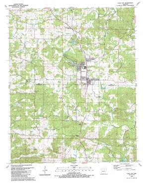
Cave City Topo Map Arkansas
To zoom in, hover over the map of Cave City
USGS Topo Quad 35091h5 - 1:24,000 scale
| Topo Map Name: | Cave City |
| USGS Topo Quad ID: | 35091h5 |
| Print Size: | ca. 21 1/4" wide x 27" high |
| Southeast Coordinates: | 35.875° N latitude / 91.5° W longitude |
| Map Center Coordinates: | 35.9375° N latitude / 91.5625° W longitude |
| U.S. State: | AR |
| Filename: | o35091h5.jpg |
| Download Map JPG Image: | Cave City topo map 1:24,000 scale |
| Map Type: | Topographic |
| Topo Series: | 7.5´ |
| Map Scale: | 1:24,000 |
| Source of Map Images: | United States Geological Survey (USGS) |
| Alternate Map Versions: |
Cave City AR 1943, updated 1956 Download PDF Buy paper map Cave City AR 1943, updated 1956 Download PDF Buy paper map Cave City AR 1943, updated 1982 Download PDF Buy paper map Cave City AR 1989, updated 1990 Download PDF Buy paper map Cave City AR 2011 Download PDF Buy paper map Cave City AR 2014 Download PDF Buy paper map |
1:24,000 Topo Quads surrounding Cave City
> Back to 35091e1 at 1:100,000 scale
> Back to 35090a1 at 1:250,000 scale
> Back to U.S. Topo Maps home
Cave City topo map: Gazetteer
Cave City: Dams
Green Acres Estate Lake One Dam elevation 193m 633′Lake Cave City Dam elevation 162m 531′
Three Dam elevation 209m 685′
Cave City: Mines
A G Gray Mine elevation 197m 646′Ball Mine elevation 181m 593′
Cochran Prospect elevation 184m 603′
E W Roach Prospect elevation 157m 515′
Eliza Patterson Prospect elevation 189m 620′
Hawkins Mine elevation 195m 639′
Jackson Prospect elevation 222m 728′
Jeff Weaver Prospect elevation 194m 636′
K D Aldridge Prospect elevation 228m 748′
M D Aldridge Prospect elevation 229m 751′
Matlock Mine elevation 212m 695′
McGee Mine elevation 178m 583′
McLeod Prospect elevation 187m 613′
Milligan Prospect elevation 196m 643′
Milligan-Perrin Prospect elevation 187m 613′
Smith Prospect elevation 145m 475′
Story Mine elevation 233m 764′
W T Gray Mine elevation 184m 603′
Woodyard Prospect elevation 222m 728′
Cave City: Parks
Doctor Toms Park elevation 207m 679′Cave City: Populated Places
Cave City elevation 205m 672′Hickory Valley elevation 182m 597′
Maxville elevation 192m 629′
Cave City: Post Offices
Cave City Post Office elevation 202m 662′Cave City: Reservoirs
Lake Cave City elevation 162m 531′Lower Lake - Green Acres Estates elevation 193m 633′
Upper Lake - Green Acres Estates elevation 209m 685′
Cave City: Springs
Jackson Springs elevation 180m 590′Cave City: Streams
Barnett Creek elevation 136m 446′Basket Creek elevation 135m 442′
Jackson Creek elevation 145m 475′
Johnson Branch elevation 136m 446′
Lick Fork elevation 137m 449′
Stanfield Branch elevation 157m 515′
Wooldridge Creek elevation 158m 518′
Cave City: Summits
Bray Hill elevation 193m 633′Gray Hill elevation 195m 639′
Hawkins Hill elevation 203m 666′
Hills Hill elevation 213m 698′
Jesse Pines elevation 184m 603′
Smith Hill elevation 191m 626′
White Hill elevation 242m 793′
Willmuth Hill elevation 215m 705′
Cave City: Valleys
Dokken Hollow elevation 159m 521′Goat Den elevation 164m 538′
Hunt Hollow elevation 125m 410′
Cave City digital topo map on disk
Buy this Cave City topo map showing relief, roads, GPS coordinates and other geographical features, as a high-resolution digital map file on DVD:


