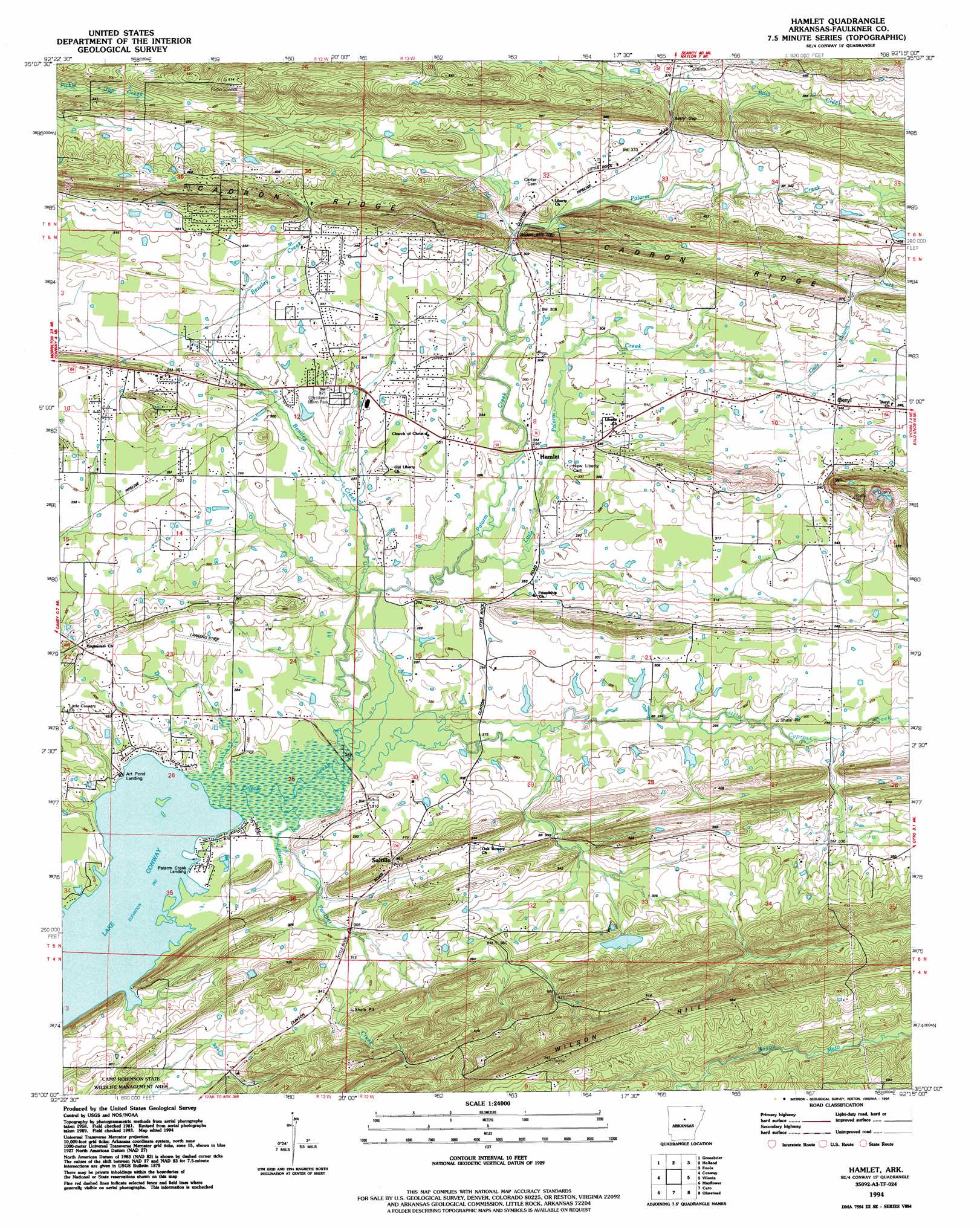
Hamlet Topo Map Arkansas
To zoom in, hover over the map of Hamlet
USGS Topo Quad 35092a3 - 1:24,000 scale
| Topo Map Name: | Hamlet |
| USGS Topo Quad ID: | 35092a3 |
| Print Size: | ca. 21 1/4" wide x 27" high |
| Southeast Coordinates: | 35° N latitude / 92.25° W longitude |
| Map Center Coordinates: | 35.0625° N latitude / 92.3125° W longitude |
| U.S. State: | AR |
| Filename: | o35092a3.jpg |
| Download Map JPG Image: | Hamlet topo map 1:24,000 scale |
| Map Type: | Topographic |
| Topo Series: | 7.5´ |
| Map Scale: | 1:24,000 |
| Source of Map Images: | United States Geological Survey (USGS) |
| Alternate Map Versions: |
Hamlet AR 1961, updated 1966 Download PDF Buy paper map Hamlet AR 1961, updated 1975 Download PDF Buy paper map Hamlet AR 1961, updated 1986 Download PDF Buy paper map Hamlet AR 1994, updated 1994 Download PDF Buy paper map Hamlet AR 2011 Download PDF Buy paper map Hamlet AR 2014 Download PDF Buy paper map |
1:24,000 Topo Quads surrounding Hamlet
Springfield |
Damascus |
Guy |
Barney |
Rose Bud |
Menifee |
Greenbrier |
Holland |
Enola |
Mount Vernon |
Gleason |
Conway |
Hamlet |
Vilonia |
Mountain Springs |
Fourche |
Mayflower |
Cato |
Olmstead |
Cabot |
Ferndale |
Pinnacle Mountain |
North Little Rock |
Mcalmont |
Jacksonville |
> Back to 35092a1 at 1:100,000 scale
> Back to 35092a1 at 1:250,000 scale
> Back to U.S. Topo Maps home
Hamlet topo map: Gazetteer
Hamlet: Airports
Poes Airport elevation 89m 291′Hamlet: Crossings
Beaverdam Ford (historical) elevation 81m 265′Hamlet: Dams
Blacks Lake Dam elevation 90m 295′Blacks Lake Number Two Dam elevation 93m 305′
Deihl Lake Dam elevation 118m 387′
Parks Lake Dam elevation 82m 269′
Hamlet: Gaps
Berry Gap elevation 112m 367′Roden Mill Gap elevation 91m 298′
Hamlet: Parks
Crest Lawn Memorial Park elevation 93m 305′Hamlet: Populated Places
Beryl elevation 106m 347′Hamlet elevation 91m 298′
Saltillo elevation 108m 354′
Sunny Gap (historical) elevation 103m 337′
Hamlet: Reservoirs
Blacks Lake elevation 90m 295′Blacks Lake Number Two elevation 93m 305′
Deihl Lake elevation 118m 387′
Parks Lake elevation 82m 269′
Hamlet: Ridges
Cadron Ridge elevation 144m 472′Hamlet: Streams
Bass Creek elevation 99m 324′Bennetts River elevation 81m 265′
Bentley Creek elevation 81m 265′
Haw Creek elevation 83m 272′
Little Cypress Creek elevation 82m 269′
Little Palarm Creek elevation 83m 272′
Panther Creek elevation 80m 262′
Hamlet: Summits
Fourmile Hill elevation 197m 646′Hamlet digital topo map on disk
Buy this Hamlet topo map showing relief, roads, GPS coordinates and other geographical features, as a high-resolution digital map file on DVD: