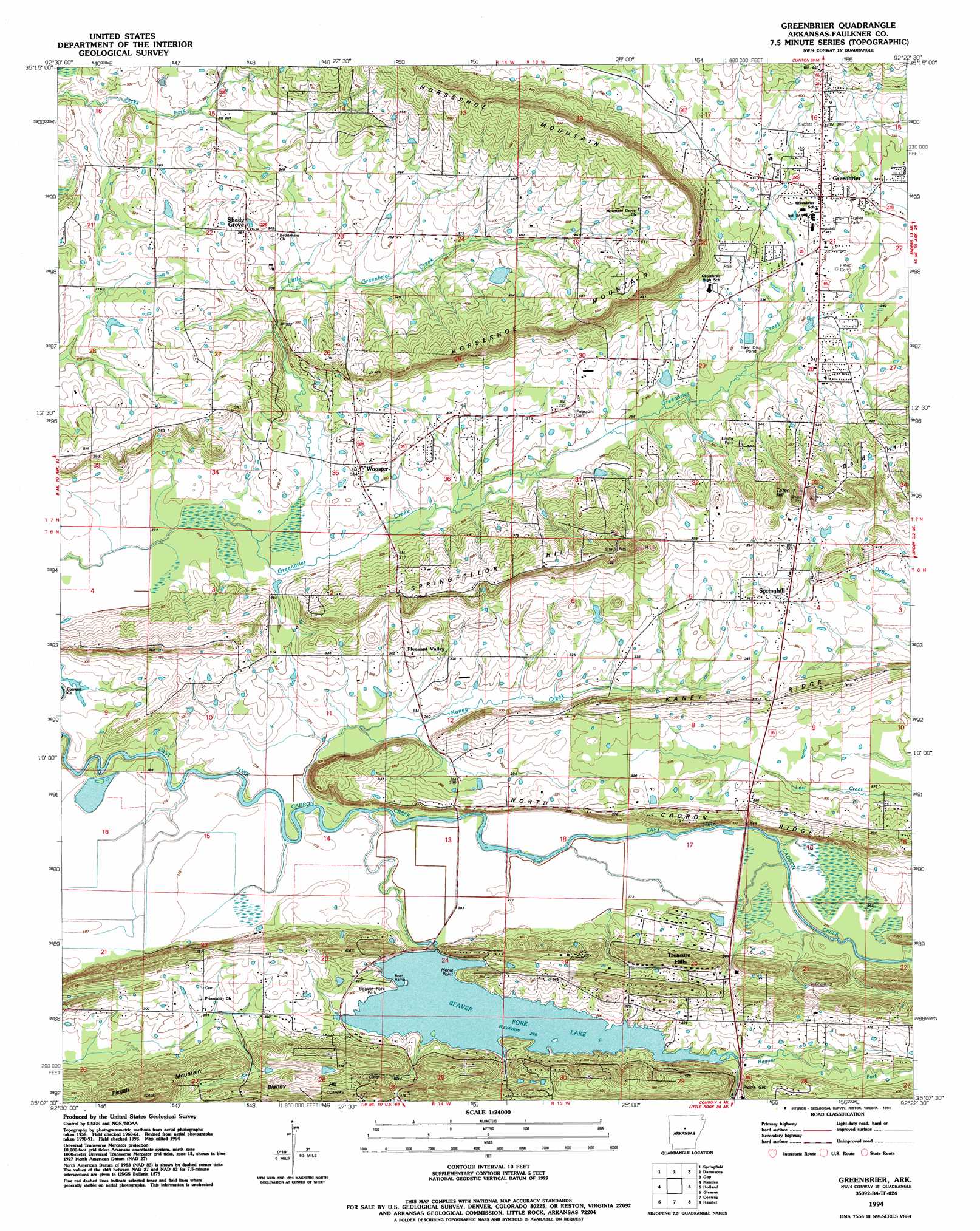
Greenbrier Topo Map Arkansas
To zoom in, hover over the map of Greenbrier
USGS Topo Quad 35092b4 - 1:24,000 scale
| Topo Map Name: | Greenbrier |
| USGS Topo Quad ID: | 35092b4 |
| Print Size: | ca. 21 1/4" wide x 27" high |
| Southeast Coordinates: | 35.125° N latitude / 92.375° W longitude |
| Map Center Coordinates: | 35.1875° N latitude / 92.4375° W longitude |
| U.S. State: | AR |
| Filename: | o35092b4.jpg |
| Download Map JPG Image: | Greenbrier topo map 1:24,000 scale |
| Map Type: | Topographic |
| Topo Series: | 7.5´ |
| Map Scale: | 1:24,000 |
| Source of Map Images: | United States Geological Survey (USGS) |
| Alternate Map Versions: |
Greenbrier AR 1961, updated 1966 Download PDF Buy paper map Greenbrier AR 1961, updated 1982 Download PDF Buy paper map Greenbrier AR 1994, updated 1994 Download PDF Buy paper map Greenbrier AR 2011 Download PDF Buy paper map Greenbrier AR 2014 Download PDF Buy paper map |
1:24,000 Topo Quads surrounding Greenbrier
Cleveland |
Formosa |
Bee Branch |
Morganton |
Quitman |
Solgohachia |
Springfield |
Damascus |
Guy |
Barney |
Morrilton East |
Menifee |
Greenbrier |
Holland |
Enola |
Houston |
Gleason |
Conway |
Hamlet |
Vilonia |
Martindale |
Fourche |
Mayflower |
Cato |
Olmstead |
> Back to 35092a1 at 1:100,000 scale
> Back to 35092a1 at 1:250,000 scale
> Back to U.S. Topo Maps home
Greenbrier topo map: Gazetteer
Greenbrier: Bridges
King Bridge elevation 82m 269′Terry Bridge (historical) elevation 80m 262′
Greenbrier: Capes
Picnic Point elevation 100m 328′Greenbrier: Crossings
Davenport Ford elevation 79m 259′Greenbrier: Dams
Beaver Fork Lake Dam elevation 83m 272′Dears Pond Dam elevation 81m 265′
Lawrence Lake Dam elevation 94m 308′
Torian Lake Dam elevation 79m 259′
Greenbrier: Gaps
Pickle Gap elevation 94m 308′Greenbrier: Populated Places
Greenbrier elevation 110m 360′Lakeview Acres elevation 125m 410′
Old Linder (historical) elevation 100m 328′
Pickles Gap (historical) elevation 93m 305′
Pleasant Valley elevation 92m 301′
Shady Grove elevation 111m 364′
Springhill elevation 112m 367′
Wooster elevation 96m 314′
Greenbrier: Reservoirs
Beaver Fork Lake elevation 83m 272′Dears Pond elevation 81m 265′
Lawrences Lake elevation 94m 308′
Torian Lake elevation 79m 259′
Greenbrier: Ridges
Horseshoe Mountain elevation 174m 570′Kaney Ridge elevation 118m 387′
North Cadron Ridge elevation 116m 380′
Greenbrier: Streams
Beaver Fork elevation 79m 259′Clifton Branch elevation 89m 291′
East Fork Cadron Creek elevation 79m 259′
Kaney Creek elevation 79m 259′
Little Greenbrier Creek elevation 82m 269′
Pickle Gap Creek elevation 88m 288′
Greenbrier: Summits
Blaney Hill elevation 153m 501′Pisgah Mountain elevation 183m 600′
Springfellor Hill elevation 156m 511′
Tater Hill elevation 149m 488′
Greenbrier digital topo map on disk
Buy this Greenbrier topo map showing relief, roads, GPS coordinates and other geographical features, as a high-resolution digital map file on DVD: