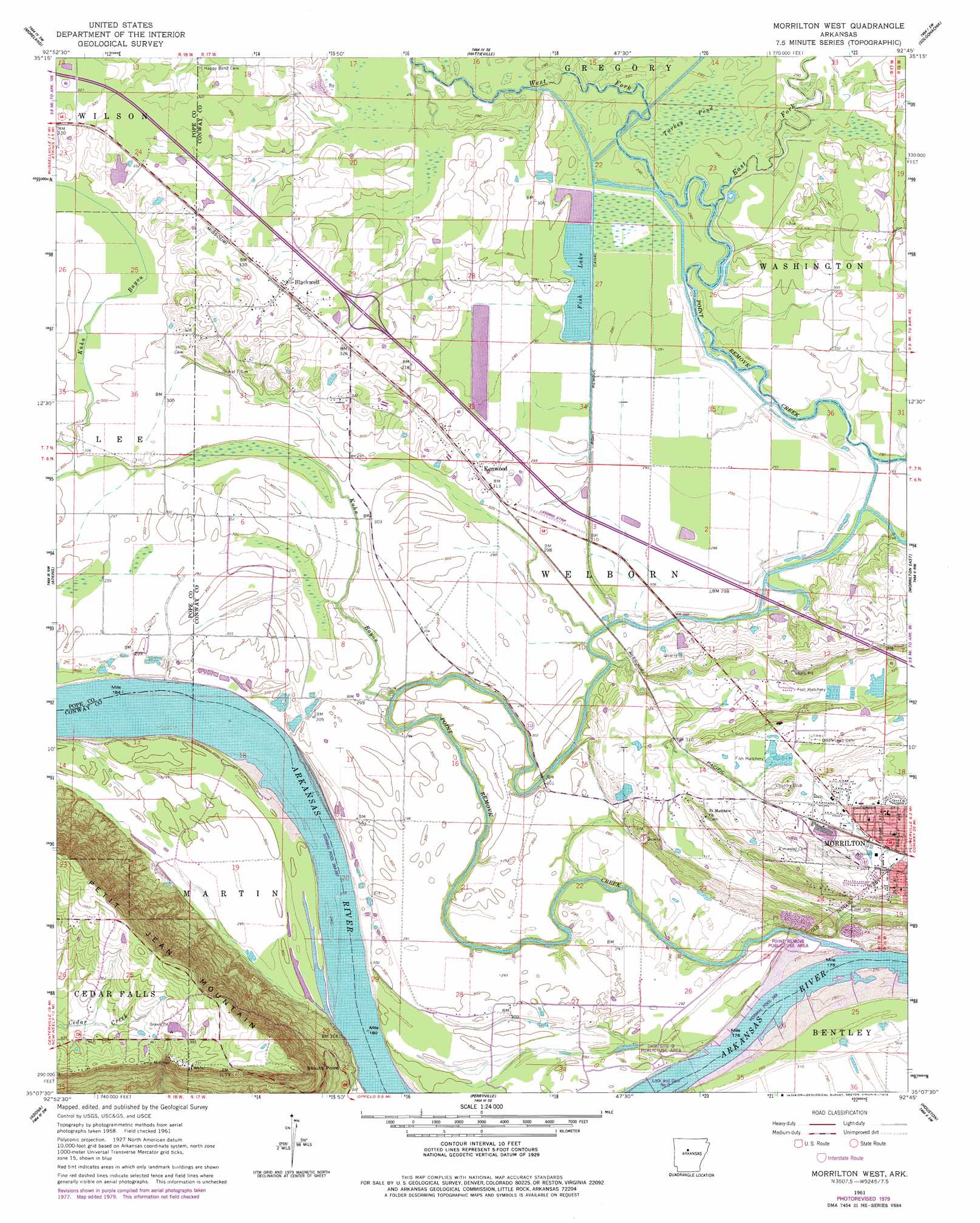
Morrilton West Topo Map Arkansas
To zoom in, hover over the map of Morrilton West
USGS Topo Quad 35092b7 - 1:24,000 scale
| Topo Map Name: | Morrilton West |
| USGS Topo Quad ID: | 35092b7 |
| Print Size: | ca. 21 1/4" wide x 27" high |
| Southeast Coordinates: | 35.125° N latitude / 92.75° W longitude |
| Map Center Coordinates: | 35.1875° N latitude / 92.8125° W longitude |
| U.S. State: | AR |
| Filename: | o35092b7.jpg |
| Download Map JPG Image: | Morrilton West topo map 1:24,000 scale |
| Map Type: | Topographic |
| Topo Series: | 7.5´ |
| Map Scale: | 1:24,000 |
| Source of Map Images: | United States Geological Survey (USGS) |
| Alternate Map Versions: |
Morrilton West AR 1961, updated 1962 Download PDF Buy paper map Morrilton West AR 1961, updated 1968 Download PDF Buy paper map Morrilton West AR 1961, updated 1979 Download PDF Buy paper map Morrilton West AR 1991, updated 1995 Download PDF Buy paper map Morrilton West AR 2011 Download PDF Buy paper map Morrilton West AR 2014 Download PDF Buy paper map |
1:24,000 Topo Quads surrounding Morrilton West
Dover |
Hector |
Jerusalem |
Cleveland |
Formosa |
Russellville East |
Moreland |
Hattieville |
Solgohachia |
Springfield |
Holla Bend |
Atkins |
Morrilton West |
Morrilton East |
Menifee |
Casa |
Adona |
Perryville |
Houston |
Gleason |
Nimrod |
Aplin |
Thornburg |
Martindale |
Fourche |
> Back to 35092a1 at 1:100,000 scale
> Back to 35092a1 at 1:250,000 scale
> Back to U.S. Topo Maps home
Morrilton West topo map: Gazetteer
Morrilton West: Airports
Morrilton Airport elevation 90m 295′Morrilton West: Canals
Point Remove Canal elevation 88m 288′Morrilton West: Cliffs
Stouts Point elevation 166m 544′Morrilton West: Crossings
Interchange 101 elevation 98m 321′Morrilton West: Dams
Fish Lake Dam elevation 89m 291′Lock and Dam Number Nine elevation 83m 272′
Morrilton West: Parks
Dam Site 9 Public Use Area elevation 85m 278′Point Remove Public Use Area elevation 84m 275′
Morrilton West: Populated Places
Blackwell elevation 100m 328′Country Estates elevation 98m 321′
Index (historical) elevation 299m 980′
Kenwood elevation 95m 311′
Spring Meadows elevation 107m 351′
Morrilton West: Reservoirs
Fish Lake elevation 89m 291′Pool Nine elevation 83m 272′
Morrilton West: Streams
Barns Branch elevation 88m 288′East Fork Point Remove Creek elevation 89m 291′
Kuhn Bayou elevation 81m 265′
Point Remove Creek elevation 79m 259′
Point Remove Creek Old Channel elevation 89m 291′
West Fork Point Remove Creek elevation 89m 291′
Morrilton West: Swamps
Turkey Pond elevation 89m 291′Morrilton West digital topo map on disk
Buy this Morrilton West topo map showing relief, roads, GPS coordinates and other geographical features, as a high-resolution digital map file on DVD: