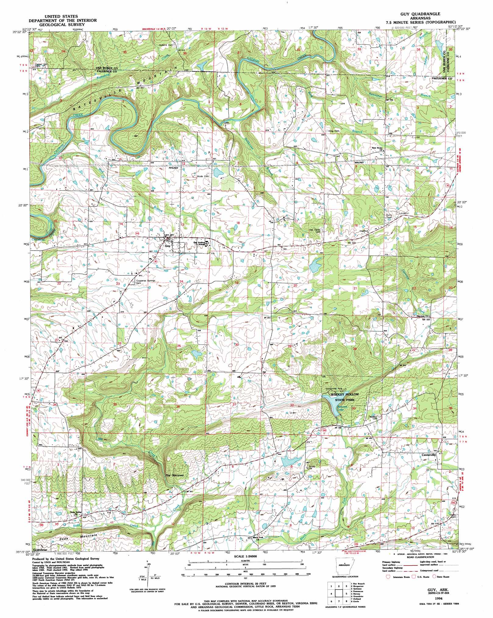
Guy Topo Map Arkansas
To zoom in, hover over the map of Guy
USGS Topo Quad 35092c3 - 1:24,000 scale
| Topo Map Name: | Guy |
| USGS Topo Quad ID: | 35092c3 |
| Print Size: | ca. 21 1/4" wide x 27" high |
| Southeast Coordinates: | 35.25° N latitude / 92.25° W longitude |
| Map Center Coordinates: | 35.3125° N latitude / 92.3125° W longitude |
| U.S. State: | AR |
| Filename: | o35092c3.jpg |
| Download Map JPG Image: | Guy topo map 1:24,000 scale |
| Map Type: | Topographic |
| Topo Series: | 7.5´ |
| Map Scale: | 1:24,000 |
| Source of Map Images: | United States Geological Survey (USGS) |
| Alternate Map Versions: |
Guy AR 1961, updated 1966 Download PDF Buy paper map Guy AR 1961, updated 1980 Download PDF Buy paper map Guy AR 1994, updated 1994 Download PDF Buy paper map Guy AR 2011 Download PDF Buy paper map Guy AR 2014 Download PDF Buy paper map |
1:24,000 Topo Quads surrounding Guy
Scotland |
Clinton |
Fairfield Bay |
Greers Ferry |
Brownsville |
Formosa |
Bee Branch |
Morganton |
Quitman |
Heber Springs |
Springfield |
Damascus |
Guy |
Barney |
Rose Bud |
Menifee |
Greenbrier |
Holland |
Enola |
Mount Vernon |
Gleason |
Conway |
Hamlet |
Vilonia |
Mountain Springs |
> Back to 35092a1 at 1:100,000 scale
> Back to 35092a1 at 1:250,000 scale
> Back to U.S. Topo Maps home
Guy topo map: Gazetteer
Guy: Dams
Bivans Lake Dam elevation 220m 721′Lake Bennett Dam elevation 148m 485′
Montgomery Lake Dam elevation 198m 649′
Guy: Gaps
The Narrows elevation 133m 436′Guy: Parks
Centerville Park elevation 162m 531′Guy: Populated Places
Centerville elevation 141m 462′Guy elevation 208m 682′
Old Texas elevation 244m 800′
Rowlett (historical) elevation 210m 688′
Soda Valley elevation 126m 413′
Guy: Reservoirs
Bivans Lake elevation 220m 721′Lake Bennett elevation 148m 485′
Montgomery Lake elevation 198m 649′
Guy: Streams
Kennimer Branch elevation 155m 508′King Branch elevation 147m 482′
Soda Creek elevation 98m 321′
Stillhouse Branch elevation 146m 479′
Wolf Branch elevation 138m 452′
Guy: Summits
Batesville Mountain elevation 205m 672′Soda Mountain elevation 167m 547′
Guy: Valleys
Soda Valley elevation 117m 383′Wooley Hollow elevation 149m 488′
Guy digital topo map on disk
Buy this Guy topo map showing relief, roads, GPS coordinates and other geographical features, as a high-resolution digital map file on DVD: