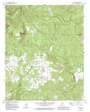
Jerusalem Topo Map Arkansas
To zoom in, hover over the map of Jerusalem
USGS Topo Quad 35092d7 - 1:24,000 scale
| Topo Map Name: | Jerusalem |
| USGS Topo Quad ID: | 35092d7 |
| Print Size: | ca. 21 1/4" wide x 27" high |
| Southeast Coordinates: | 35.375° N latitude / 92.75° W longitude |
| Map Center Coordinates: | 35.4375° N latitude / 92.8125° W longitude |
| U.S. State: | AR |
| Filename: | o35092d7.jpg |
| Download Map JPG Image: | Jerusalem topo map 1:24,000 scale |
| Map Type: | Topographic |
| Topo Series: | 7.5´ |
| Map Scale: | 1:24,000 |
| Source of Map Images: | United States Geological Survey (USGS) |
| Alternate Map Versions: |
Jerusalem AR 1962, updated 1963 Download PDF Buy paper map Jerusalem AR 1962, updated 1975 Download PDF Buy paper map Jerusalem AR 1962, updated 1983 Download PDF Buy paper map Jerusalem AR 1990, updated 1995 Download PDF Buy paper map Jerusalem AR 2011 Download PDF Buy paper map Jerusalem AR 2014 Download PDF Buy paper map |
| FStopo: | US Forest Service topo Jerusalem is available: Download FStopo PDF Download FStopo TIF |
1:24,000 Topo Quads surrounding Jerusalem
> Back to 35092a1 at 1:100,000 scale
> Back to 35092a1 at 1:250,000 scale
> Back to U.S. Topo Maps home
Jerusalem topo map: Gazetteer
Jerusalem: Cliffs
Molten Bluff elevation 197m 646′Jerusalem: Dams
West Fork Point Remove Creek Site 11 Dam elevation 154m 505′West Fork Point Remove Creek Site Eight Dam elevation 176m 577′
West Fork Point Remove Creek Site Five Dam elevation 186m 610′
West Fork Point Remove Creek Site Seven Dam elevation 164m 538′
West Fork Point Remove Creek Site Six Dam elevation 183m 600′
West Fork Point Remove Creek Site Three Dam elevation 253m 830′
Jerusalem: Flats
Doyle Flat elevation 337m 1105′Jerusalem: Gaps
Grassy Gap elevation 474m 1555′Jerusalem: Oilfields
Jerusalem Gas Field elevation 202m 662′Jerusalem: Populated Places
Appleton elevation 152m 498′Gobblers Point elevation 200m 656′
Jerusalem elevation 231m 757′
Stumptoe elevation 323m 1059′
Jerusalem: Post Offices
Jerusalem Post Office elevation 233m 764′Jerusalem: Reservoirs
Brock Creek Lake elevation 246m 807′Brock Creek Lake elevation 253m 830′
West Fork Point Remove Creek Site 11 Reservoir elevation 154m 505′
West Fork Point Remove Creek Site Eight Reservoir elevation 176m 577′
West Fork Point Remove Creek Site Five Reservoir elevation 186m 610′
West Fork Point Remove Creek Site Seven Reservoir elevation 164m 538′
West Fork Point Remove Creek Site Six Reservoir elevation 183m 600′
Jerusalem: Ridges
Dude Ridge elevation 200m 656′Jerusalem: Streams
Rock Creek elevation 141m 462′Jerusalem: Summits
Busted Mountain elevation 232m 761′Evans Mountain elevation 594m 1948′
Griffin Mountain elevation 306m 1003′
Tackett Mountain elevation 397m 1302′
Tar Kiln Mountain elevation 252m 826′
Wills Mountain elevation 317m 1040′
Jerusalem digital topo map on disk
Buy this Jerusalem topo map showing relief, roads, GPS coordinates and other geographical features, as a high-resolution digital map file on DVD:


