Hector Topo Map Arkansas
To zoom in, hover over the map of Hector
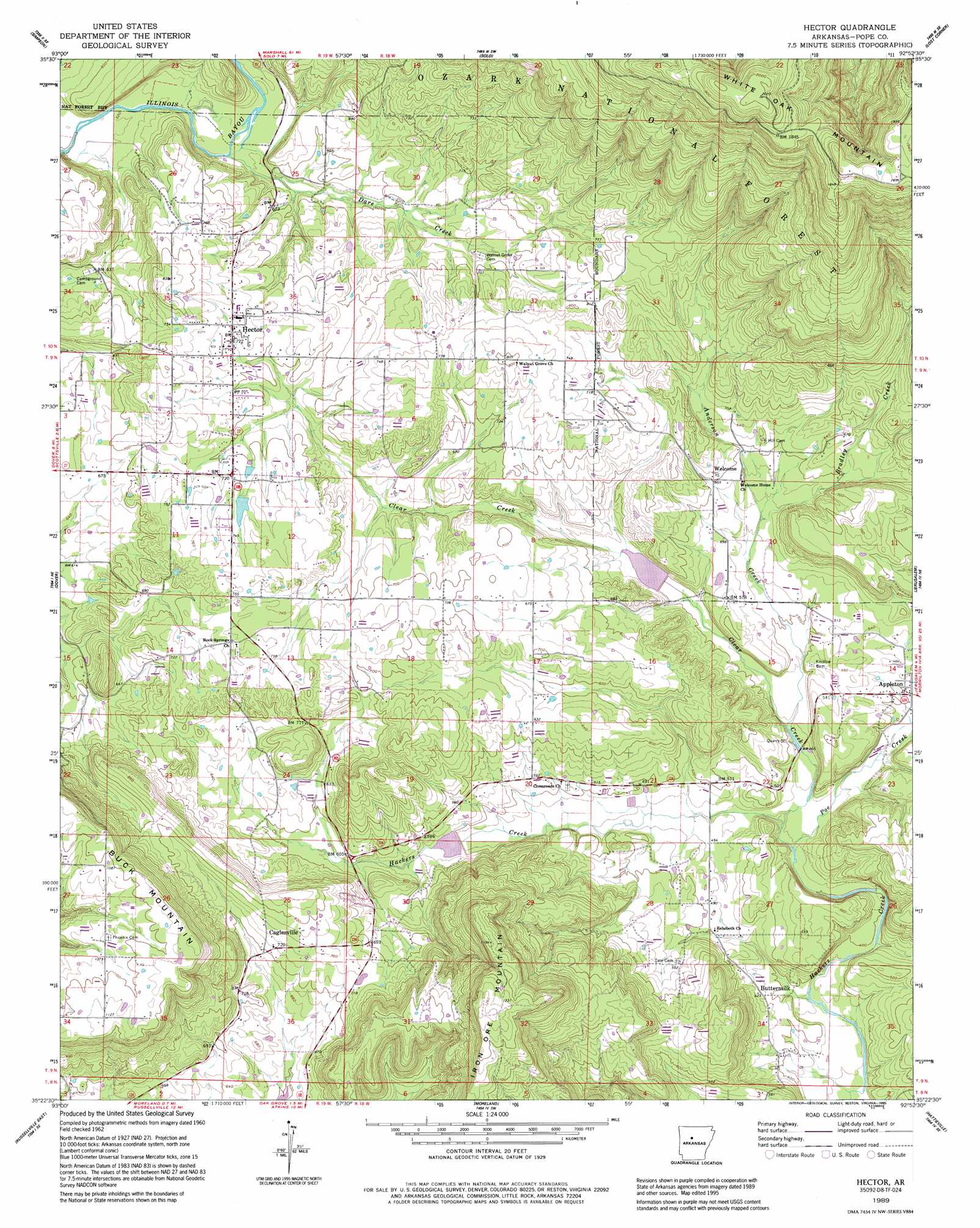
USGS Topo Quad 35092d8 - 1:24,000 scale
| Topo Map Name: | Hector |
| USGS Topo Quad ID: | 35092d8 |
| Print Size: | ca. 21 1/4" wide x 27" high |
| Southeast Coordinates: | 35.375° N latitude / 92.875° W longitude |
| Map Center Coordinates: | 35.4375° N latitude / 92.9375° W longitude |
| U.S. State: | AR |
| Filename: | o35092d8.jpg |
| Download Map JPG Image: | Hector topo map 1:24,000 scale |
| Map Type: | Topographic |
| Topo Series: | 7.5´ |
| Map Scale: | 1:24,000 |
| Source of Map Images: | United States Geological Survey (USGS) |
| Alternate Map Versions: |
Hector AR 1962, updated 1963 Download PDF Buy paper map Hector AR 1962, updated 1973 Download PDF Buy paper map Hector AR 1989, updated 1995 Download PDF Buy paper map Hector AR 2011 Download PDF Buy paper map Hector AR 2014 Download PDF Buy paper map |
| FStopo: | US Forest Service topo Hector is available: Download FStopo PDF Download FStopo TIF |
1:24,000 Topo Quads surrounding Hector
Fort Douglas |
Sand Gap |
Smyrna |
Tilly |
Alread |
Treat |
Simpson |
Solo |
Lost Corner |
Rex |
Lee Mountain |
Dover |
Hector |
Jerusalem |
Cleveland |
Russellville West |
Russellville East |
Moreland |
Hattieville |
Solgohachia |
Dardanelle |
Holla Bend |
Atkins |
Morrilton West |
Morrilton East |
> Back to 35092a1 at 1:100,000 scale
> Back to 35092a1 at 1:250,000 scale
> Back to U.S. Topo Maps home
Hector topo map: Gazetteer
Hector: Dams
West Fork Point Remove Creek Site 10 Dam elevation 177m 580′West Fork Point Remove Creek Site Nine Dam elevation 196m 643′
Hector: Populated Places
Boiling Springs (historical) elevation 193m 633′Buttermilk elevation 127m 416′
Caglesville elevation 238m 780′
Hector elevation 219m 718′
Leta (historical) elevation 214m 702′
Rock Springs elevation 223m 731′
Walnut Grove elevation 213m 698′
Welcome elevation 183m 600′
Hector: Post Offices
Appleton Post Office (historical) elevation 151m 495′Hector: Reservoirs
West Fork Point Remove Creek Site 10 Reservoir elevation 177m 580′West Fork Point Remove Creek Site Nine Reservoir elevation 196m 643′
Hector: Streams
Anderson Creek elevation 140m 459′Bradley Creek elevation 166m 544′
Clear Creek elevation 160m 524′
Dare Creek elevation 157m 515′
Poe Creek elevation 126m 413′
Hector: Summits
Buck Mountain elevation 349m 1145′Iron Ore Mountain elevation 386m 1266′
White Oak Mountain elevation 614m 2014′
Hector digital topo map on disk
Buy this Hector topo map showing relief, roads, GPS coordinates and other geographical features, as a high-resolution digital map file on DVD: