Canaan Topo Map Arkansas
To zoom in, hover over the map of Canaan
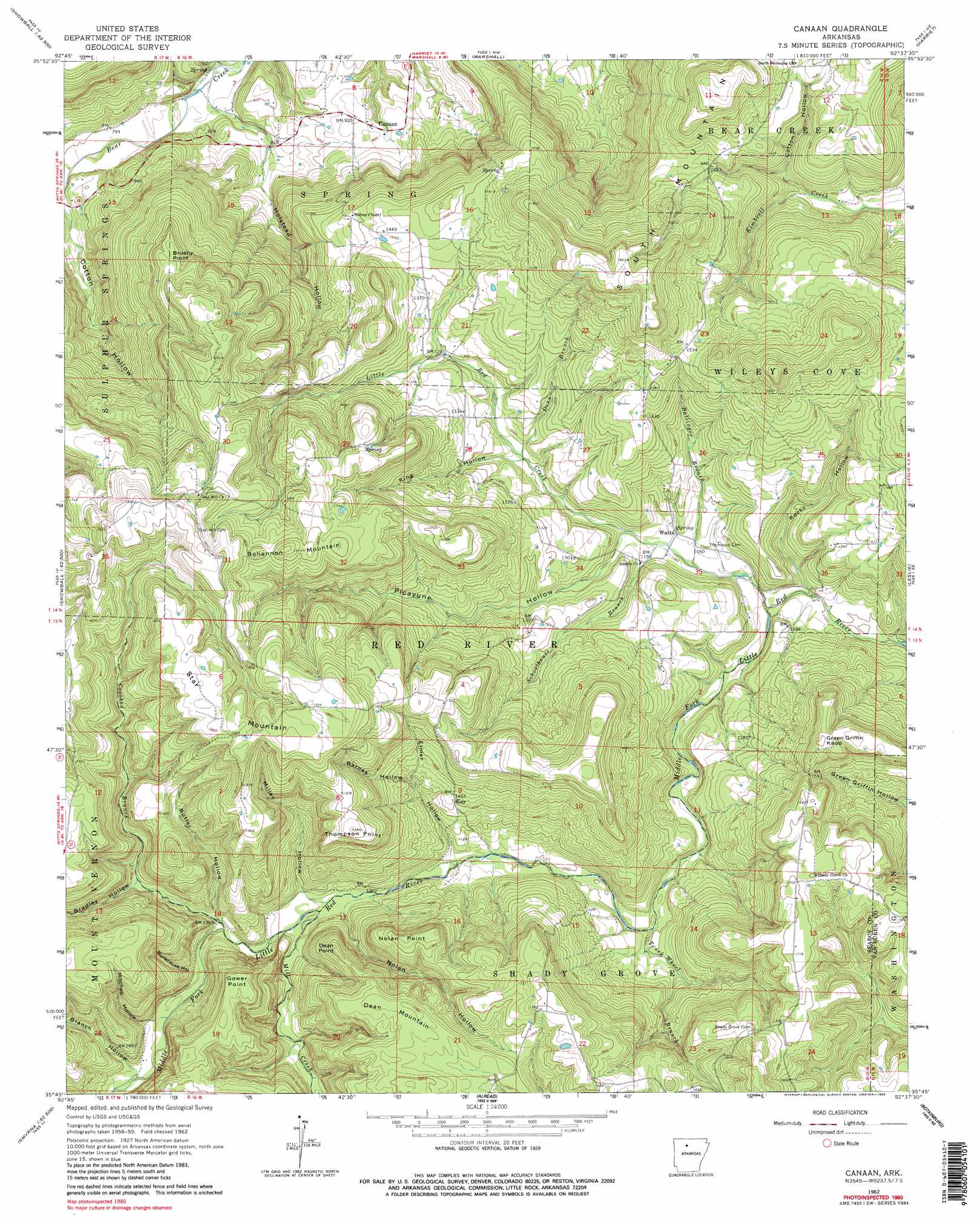
USGS Topo Quad 35092g6 - 1:24,000 scale
| Topo Map Name: | Canaan |
| USGS Topo Quad ID: | 35092g6 |
| Print Size: | ca. 21 1/4" wide x 27" high |
| Southeast Coordinates: | 35.75° N latitude / 92.625° W longitude |
| Map Center Coordinates: | 35.8125° N latitude / 92.6875° W longitude |
| U.S. State: | AR |
| Filename: | o35092g6.jpg |
| Download Map JPG Image: | Canaan topo map 1:24,000 scale |
| Map Type: | Topographic |
| Topo Series: | 7.5´ |
| Map Scale: | 1:24,000 |
| Source of Map Images: | United States Geological Survey (USGS) |
| Alternate Map Versions: |
Canaan AR 1962, updated 1964 Download PDF Buy paper map Canaan AR 1962, updated 1983 Download PDF Buy paper map Canaan AR 1962, updated 1983 Download PDF Buy paper map Canaan AR 2011 Download PDF Buy paper map Canaan AR 2014 Download PDF Buy paper map |
1:24,000 Topo Quads surrounding Canaan
Western Grove |
Saint Joe |
Maumee |
Cozahome |
Big Flat |
Eula |
Snowball |
Marshall |
Harriet |
Landis |
Moore |
Witts Spring |
Canaan |
Leslie |
Oxley |
Smyrna |
Tilly |
Alread |
Botkinburg |
Old Lexington |
Solo |
Lost Corner |
Rex |
Scotland |
Clinton |
> Back to 35092e1 at 1:100,000 scale
> Back to 35092a1 at 1:250,000 scale
> Back to U.S. Topo Maps home
Canaan topo map: Gazetteer
Canaan: Cliffs
Gower Point elevation 527m 1729′Nolan Point elevation 532m 1745′
Canaan: Populated Places
Canaan elevation 284m 931′Kay elevation 440m 1443′
Watts elevation 354m 1161′
Canaan: Streams
Ballinger Branch elevation 341m 1118′Crooked Branch elevation 395m 1295′
Dean Branch elevation 366m 1200′
Little Red Creek elevation 334m 1095′
Mill Creek elevation 382m 1253′
Schoolhouse Branch elevation 346m 1135′
Truck Wheel Branch elevation 356m 1167′
Canaan: Summits
Bohannon Mountain elevation 554m 1817′Brushy Point elevation 494m 1620′
Dean Mountain elevation 542m 1778′
Dean Point elevation 503m 1650′
Green Griffin Knob elevation 513m 1683′
South Mountain elevation 575m 1886′
Star Mountain elevation 596m 1955′
Thompson Point elevation 556m 1824′
Canaan: Valleys
Barnes Hollow elevation 417m 1368′Bradley Hollow elevation 415m 1361′
Branch Hollow elevation 416m 1364′
Bryan Hollow elevation 224m 734′
Bunkhouse Hollow elevation 401m 1315′
Butler Hollow elevation 398m 1305′
Cotton Hollow elevation 259m 849′
Cotton Hollow elevation 365m 1197′
Elmer Hollow elevation 371m 1217′
Holstead Hollow elevation 227m 744′
King Hollow elevation 365m 1197′
Miller Hollow elevation 381m 1250′
Mitchell Hollow elevation 410m 1345′
Nolan Hollow elevation 383m 1256′
Picayune Hollow elevation 347m 1138′
Rocky Hollow elevation 330m 1082′
Canaan digital topo map on disk
Buy this Canaan topo map showing relief, roads, GPS coordinates and other geographical features, as a high-resolution digital map file on DVD: