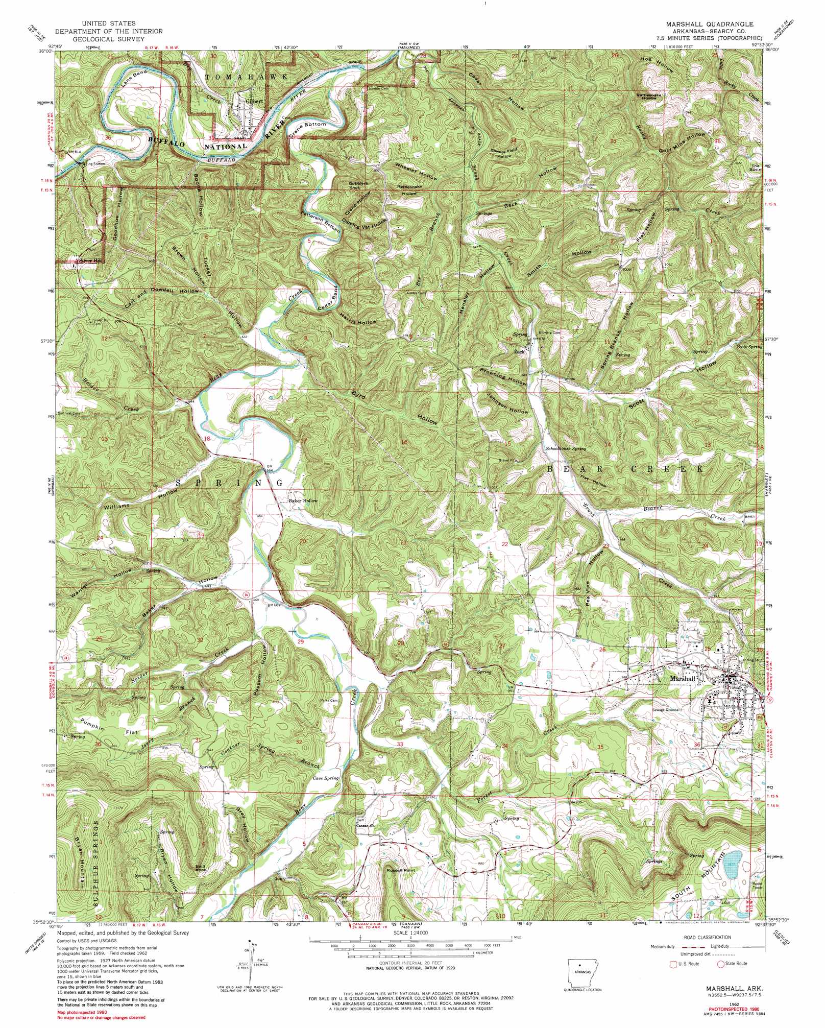
Marshall Topo Map Arkansas
To zoom in, hover over the map of Marshall
USGS Topo Quad 35092h6 - 1:24,000 scale
| Topo Map Name: | Marshall |
| USGS Topo Quad ID: | 35092h6 |
| Print Size: | ca. 21 1/4" wide x 27" high |
| Southeast Coordinates: | 35.875° N latitude / 92.625° W longitude |
| Map Center Coordinates: | 35.9375° N latitude / 92.6875° W longitude |
| U.S. State: | AR |
| Filename: | o35092h6.jpg |
| Download Map JPG Image: | Marshall topo map 1:24,000 scale |
| Map Type: | Topographic |
| Topo Series: | 7.5´ |
| Map Scale: | 1:24,000 |
| Source of Map Images: | United States Geological Survey (USGS) |
| Alternate Map Versions: |
Marshall AR 1962, updated 1964 Download PDF Buy paper map Marshall AR 1962, updated 1973 Download PDF Buy paper map Marshall AR 1962, updated 1982 Download PDF Buy paper map Marshall AR 1962, updated 1982 Download PDF Buy paper map Marshall AR 2011 Download PDF Buy paper map Marshall AR 2014 Download PDF Buy paper map |
1:24,000 Topo Quads surrounding Marshall
Everton |
Bruno |
Yellville |
Rea Valley |
Buffalo City |
Western Grove |
Saint Joe |
Maumee |
Cozahome |
Big Flat |
Eula |
Snowball |
Marshall |
Harriet |
Landis |
Moore |
Witts Spring |
Canaan |
Leslie |
Oxley |
Smyrna |
Tilly |
Alread |
Botkinburg |
Old Lexington |
> Back to 35092e1 at 1:100,000 scale
> Back to 35092a1 at 1:250,000 scale
> Back to U.S. Topo Maps home
Marshall topo map: Gazetteer
Marshall: Airports
Searcy County Airport elevation 287m 941′Marshall: Basins
The Basin elevation 307m 1007′Marshall: Bends
Cedar Bend elevation 181m 593′Crane Bottom elevation 173m 567′
Lane Bend elevation 172m 564′
Patterson Bottom elevation 178m 583′
Marshall: Capes
Russell Point elevation 363m 1190′Marshall: Dams
Lake Ferguson Dam elevation 476m 1561′Marshall: Flats
Pumpkin Flat elevation 297m 974′Marshall: Populated Places
Baker Hollow elevation 199m 652′Gilbert elevation 180m 590′
Jameson (historical) elevation 284m 931′
Lebanon (historical) elevation 205m 672′
Marshall elevation 317m 1040′
Silver Hill elevation 284m 931′
Zack elevation 202m 662′
Marshall: Reservoirs
Lake Ferguson elevation 476m 1561′Marshall: Springs
Cave Spring elevation 213m 698′Schoolhouse Spring elevation 212m 695′
Scott Spring elevation 259m 849′
Marshall: Streams
Bear Creek elevation 166m 544′Beaver Creek elevation 221m 725′
Bee Branch elevation 181m 593′
Brush Creek elevation 165m 541′
Coatner Spring Branch elevation 218m 715′
Dry Creek elevation 167m 547′
Forest Creek elevation 204m 669′
Holder Creek elevation 188m 616′
Jerry Branch elevation 211m 692′
Spider Creek elevation 199m 652′
Marshall: Summits
Bald Knob elevation 342m 1122′Bryan Mountain elevation 533m 1748′
Gobblers Knob elevation 280m 918′
Marshall: Valleys
Baker Hollow elevation 198m 649′Beck Hollow elevation 192m 629′
Boone Hollow elevation 179m 587′
Bowers Field Hollow elevation 194m 636′
Brown Hollow elevation 202m 662′
Browning Hollow elevation 205m 672′
Byrd Hollow elevation 182m 597′
Carl and Dowdell Hollow elevation 200m 656′
Cedar Hollow elevation 171m 561′
Crane Hollow elevation 178m 583′
Dipping Vat Hollow elevation 176m 577′
Flat Hollow elevation 251m 823′
Flat Hollow elevation 221m 725′
Gold Mine Hollow elevation 202m 662′
Goodhue Hollow elevation 182m 597′
Gray Hollow elevation 217m 711′
Harris Hollow elevation 202m 662′
Hensley Hollow elevation 192m 629′
Hog Hollow elevation 183m 600′
Johnson Hollow elevation 210m 688′
Pea Vine Hollow elevation 230m 754′
Possum Hollow elevation 207m 679′
Rattlesnake Hollow elevation 190m 623′
Rattlesnake Hollow elevation 195m 639′
Scott Hollow elevation 203m 666′
Smith Hollow elevation 196m 643′
Spring Branch Hollow elevation 217m 711′
Tucker Hollow elevation 181m 593′
Warner Hollow elevation 211m 692′
Wheeler Hollow elevation 191m 626′
Williams Hollow elevation 191m 626′
Marshall digital topo map on disk
Buy this Marshall topo map showing relief, roads, GPS coordinates and other geographical features, as a high-resolution digital map file on DVD: