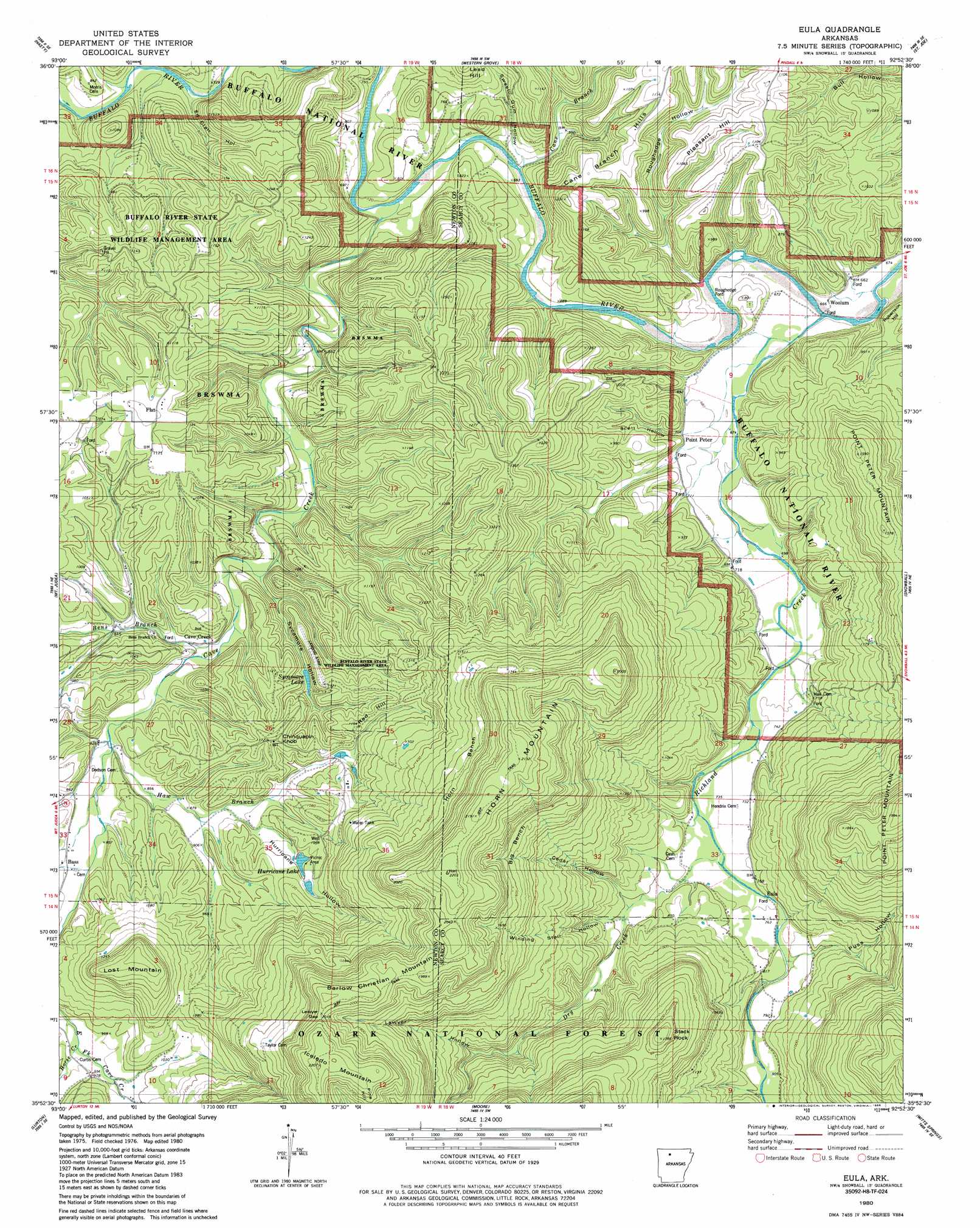
Eula Topo Map Arkansas
To zoom in, hover over the map of Eula
USGS Topo Quad 35092h8 - 1:24,000 scale
| Topo Map Name: | Eula |
| USGS Topo Quad ID: | 35092h8 |
| Print Size: | ca. 21 1/4" wide x 27" high |
| Southeast Coordinates: | 35.875° N latitude / 92.875° W longitude |
| Map Center Coordinates: | 35.9375° N latitude / 92.9375° W longitude |
| U.S. State: | AR |
| Filename: | o35092h8.jpg |
| Download Map JPG Image: | Eula topo map 1:24,000 scale |
| Map Type: | Topographic |
| Topo Series: | 7.5´ |
| Map Scale: | 1:24,000 |
| Source of Map Images: | United States Geological Survey (USGS) |
| Alternate Map Versions: |
Eula AR 1980, updated 1981 Download PDF Buy paper map Eula AR 1980, updated 1986 Download PDF Buy paper map Eula AR 2011 Download PDF Buy paper map Eula AR 2014 Download PDF Buy paper map |
| FStopo: | US Forest Service topo Eula is available: Download FStopo PDF Download FStopo TIF |
1:24,000 Topo Quads surrounding Eula
Gaither |
Harrison |
Everton |
Bruno |
Yellville |
Jasper |
Hasty |
Western Grove |
Saint Joe |
Maumee |
Parthenon |
Mount Judea |
Eula |
Snowball |
Marshall |
Deer |
Lurton |
Moore |
Witts Spring |
Canaan |
Fort Douglas |
Sand Gap |
Smyrna |
Tilly |
Alread |
> Back to 35092e1 at 1:100,000 scale
> Back to 35092a1 at 1:250,000 scale
> Back to U.S. Topo Maps home
Eula topo map: Gazetteer
Eula: Airports
Lost Mountain Wilderness Retreat Airport elevation 329m 1079′Eula: Benches
Big Bench elevation 487m 1597′Horn Bench elevation 461m 1512′
Eula: Cliffs
Cane Bluff elevation 208m 682′Clair Bluff elevation 223m 731′
John Reddell Bluff elevation 214m 702′
Eula: Crossings
Roughedge Ford elevation 204m 669′Eula: Dams
Lake Sycamore Dam elevation 270m 885′Lower Hurricane Lake Dam elevation 271m 889′
Eula: Gaps
Lawyer Gap elevation 604m 1981′The Narrows elevation 196m 643′
Eula: Lakes
Sycamore Lake elevation 271m 889′Eula: Parks
Buffalo National River elevation 351m 1151′Stack Rock Scenic Area elevation 486m 1594′
Eula: Populated Places
Bass elevation 264m 866′Cave Creek elevation 241m 790′
Dry Creek (historical) elevation 245m 803′
Eula elevation 247m 810′
Flat elevation 346m 1135′
Hall (historical) elevation 232m 761′
Horn Mountain (historical) elevation 496m 1627′
Point Peter elevation 231m 757′
Woolum elevation 200m 656′
Eula: Post Offices
Bass Post Office elevation 264m 866′Eula: Reservoirs
Hurricane Lake elevation 302m 990′Lower Hurricane Lake elevation 271m 889′
Sycamore Lake elevation 270m 885′
Eula: Streams
Bens Branch elevation 241m 790′Cane Branch elevation 210m 688′
Cave Creek elevation 202m 662′
Dry Creek elevation 224m 734′
Haw Branch elevation 252m 826′
Horse Creek elevation 284m 931′
Horse Creek elevation 287m 941′
Richland Creek elevation 198m 649′
Eula: Summits
Barlow Christian Mountain elevation 622m 2040′Chinquapin Knob elevation 351m 1151′
Horn Mountain elevation 651m 2135′
Iceledo Mountain elevation 670m 2198′
Lost Mountain elevation 479m 1571′
Pleasant Hill elevation 322m 1056′
Red Hill elevation 333m 1092′
Robertson Hill elevation 269m 882′
Stack Rock elevation 545m 1788′
Eula: Valleys
Cedar Hollow elevation 240m 787′Ed Clair Hollow elevation 220m 721′
Hurricane Hollow elevation 276m 905′
Lawyer Hollow elevation 315m 1033′
Puss Hollow elevation 235m 770′
Roughedge Hollow elevation 200m 656′
Scott Hollow elevation 229m 751′
Sweet Gum Hollow elevation 201m 659′
Sycamore Hollow elevation 244m 800′
Winding Star Hollow elevation 246m 807′
Eula digital topo map on disk
Buy this Eula topo map showing relief, roads, GPS coordinates and other geographical features, as a high-resolution digital map file on DVD: