Blue Mountain Dam Topo Map Arkansas
To zoom in, hover over the map of Blue Mountain Dam
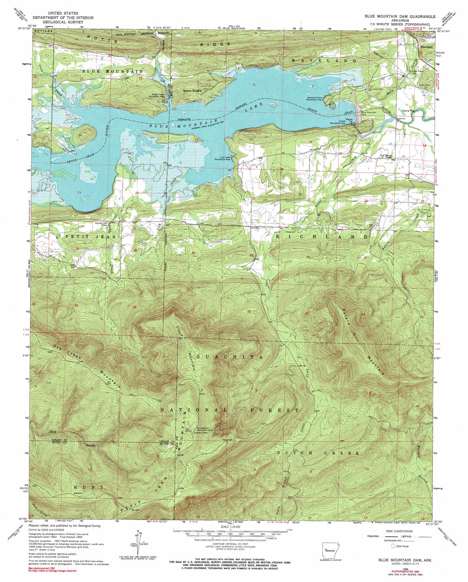
USGS Topo Quad 35093a6 - 1:24,000 scale
| Topo Map Name: | Blue Mountain Dam |
| USGS Topo Quad ID: | 35093a6 |
| Print Size: | ca. 21 1/4" wide x 27" high |
| Southeast Coordinates: | 35° N latitude / 93.625° W longitude |
| Map Center Coordinates: | 35.0625° N latitude / 93.6875° W longitude |
| U.S. State: | AR |
| Filename: | o35093a6.jpg |
| Download Map JPG Image: | Blue Mountain Dam topo map 1:24,000 scale |
| Map Type: | Topographic |
| Topo Series: | 7.5´ |
| Map Scale: | 1:24,000 |
| Source of Map Images: | United States Geological Survey (USGS) |
| Alternate Map Versions: |
Blue Mountain Dam AR 1966, updated 1978 Download PDF Buy paper map Blue Mountain Dam AR 1966, updated 1990 Download PDF Buy paper map Blue Mountain Dam AR 2011 Download PDF Buy paper map Blue Mountain Dam AR 2014 Download PDF Buy paper map |
| FStopo: | US Forest Service topo Blue Mountain Dam is available: Download FStopo PDF Download FStopo TIF |
1:24,000 Topo Quads surrounding Blue Mountain Dam
Branch |
Caulksville |
Paris |
Scranton |
New Blaine |
Booneville |
Magazine |
Blue Mountain |
Magazine Mountain Ne |
Chickalah Mountain West |
Golden City |
Sugar Grove |
Blue Mountain Dam |
Havana |
Danville |
Bee Mountain |
Freedom Mountain |
Gravelly |
Bluffton |
Rover |
Parks |
Harvey |
Little Texas |
Chula Mountain |
Onyx |
> Back to 35093a1 at 1:100,000 scale
> Back to 35092a1 at 1:250,000 scale
> Back to U.S. Topo Maps home
Blue Mountain Dam topo map: Gazetteer
Blue Mountain Dam: Dams
Blue Mountain Dam elevation 123m 403′Blue Mountain Dam: Parks
Outlet Recreation Area elevation 138m 452′Stonehouse Recreation Area elevation 734m 2408′
Blue Mountain Dam: Populated Places
Quarry Heights elevation 163m 534′Southern Home (historical) elevation 148m 485′
Waveland elevation 141m 462′
Blue Mountain Dam: Post Offices
Waveland Post Office elevation 137m 449′Blue Mountain Dam: Reservoirs
Blue Mountain Lake elevation 123m 403′Blue Mountain Dam: Ridges
Dry Creek Mountain elevation 617m 2024′Petit Jean Mountain elevation 745m 2444′
Potts Ridge elevation 222m 728′
Blue Mountain Dam: Streams
Ashley Creek elevation 116m 380′Bakers Creek elevation 150m 492′
Cedar Creek elevation 108m 354′
Crow Creek elevation 116m 380′
Ladds Creek elevation 123m 403′
Lick Creek elevation 118m 387′
Rock Creek elevation 110m 360′
Blue Mountain Dam: Summits
Flood Mountain elevation 684m 2244′Petit Jean Mountain elevation 745m 2444′
Potato Hill Mountain elevation 677m 2221′
Blue Mountain Dam digital topo map on disk
Buy this Blue Mountain Dam topo map showing relief, roads, GPS coordinates and other geographical features, as a high-resolution digital map file on DVD: