Sugar Grove Topo Map Arkansas
To zoom in, hover over the map of Sugar Grove
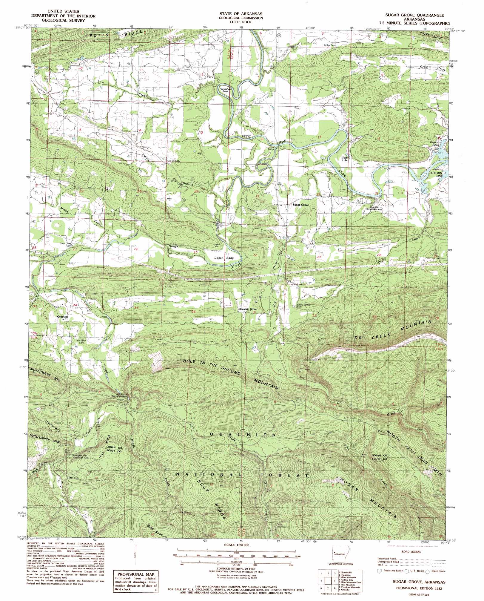
USGS Topo Quad 35093a7 - 1:24,000 scale
| Topo Map Name: | Sugar Grove |
| USGS Topo Quad ID: | 35093a7 |
| Print Size: | ca. 21 1/4" wide x 27" high |
| Southeast Coordinates: | 35° N latitude / 93.75° W longitude |
| Map Center Coordinates: | 35.0625° N latitude / 93.8125° W longitude |
| U.S. State: | AR |
| Filename: | o35093a7.jpg |
| Download Map JPG Image: | Sugar Grove topo map 1:24,000 scale |
| Map Type: | Topographic |
| Topo Series: | 7.5´ |
| Map Scale: | 1:24,000 |
| Source of Map Images: | United States Geological Survey (USGS) |
| Alternate Map Versions: |
Sugar Grove AR 1983, updated 1983 Download PDF Buy paper map Sugar Grove AR 2011 Download PDF Buy paper map Sugar Grove AR 2014 Download PDF Buy paper map |
| FStopo: | US Forest Service topo Sugar Grove is available: Download FStopo PDF Download FStopo TIF |
1:24,000 Topo Quads surrounding Sugar Grove
Charleston |
Branch |
Caulksville |
Paris |
Scranton |
Barber |
Booneville |
Magazine |
Blue Mountain |
Magazine Mountain Ne |
Ione |
Golden City |
Sugar Grove |
Blue Mountain Dam |
Havana |
Waldron |
Bee Mountain |
Freedom Mountain |
Gravelly |
Bluffton |
Boles |
Parks |
Harvey |
Little Texas |
Chula Mountain |
> Back to 35093a1 at 1:100,000 scale
> Back to 35092a1 at 1:250,000 scale
> Back to U.S. Topo Maps home
Sugar Grove topo map: Gazetteer
Sugar Grove: Bays
Beason Cove elevation 116m 380′Sugar Grove: Bends
Horseshoe Bend elevation 124m 406′Sugar Grove: Bridges
Third Bridge elevation 117m 383′Sugar Grove: Flats
Logan Eddy elevation 130m 426′Sugar Grove: Lakes
Scott Lake elevation 118m 387′Sugar Grove: Parks
Hise Hill Recreation Area elevation 138m 452′Jack Creek Recreation Area elevation 185m 606′
Knoppers Ford Recreation Area elevation 193m 633′
Sugar Grove: Populated Places
Grayson elevation 160m 524′Mountain Grove elevation 206m 675′
Sugar Grove elevation 136m 446′
Sugar Grove: Ridges
Buck Ridge elevation 340m 1115′Potts Ridge elevation 187m 613′
Sugar Grove: Streams
Cedar Creek elevation 119m 390′Dry Creek elevation 123m 403′
Huckleberry Creek elevation 185m 606′
Jack Creek elevation 173m 567′
Lick Creek elevation 121m 396′
Long Branch elevation 138m 452′
Middle Creek elevation 176m 577′
Mixon Creek elevation 133m 436′
Ramsey Creek elevation 239m 784′
Right Hand Sugar Creek elevation 195m 639′
Smiths Branch elevation 122m 400′
Sugar Creek elevation 122m 400′
Sugar Grove: Summits
Bald Knob elevation 461m 1512′Hole in the Ground Mountain elevation 357m 1171′
North Petit Jean Mountain elevation 515m 1689′
Sugar Grove digital topo map on disk
Buy this Sugar Grove topo map showing relief, roads, GPS coordinates and other geographical features, as a high-resolution digital map file on DVD: