Blue Mountain Topo Map Arkansas
To zoom in, hover over the map of Blue Mountain
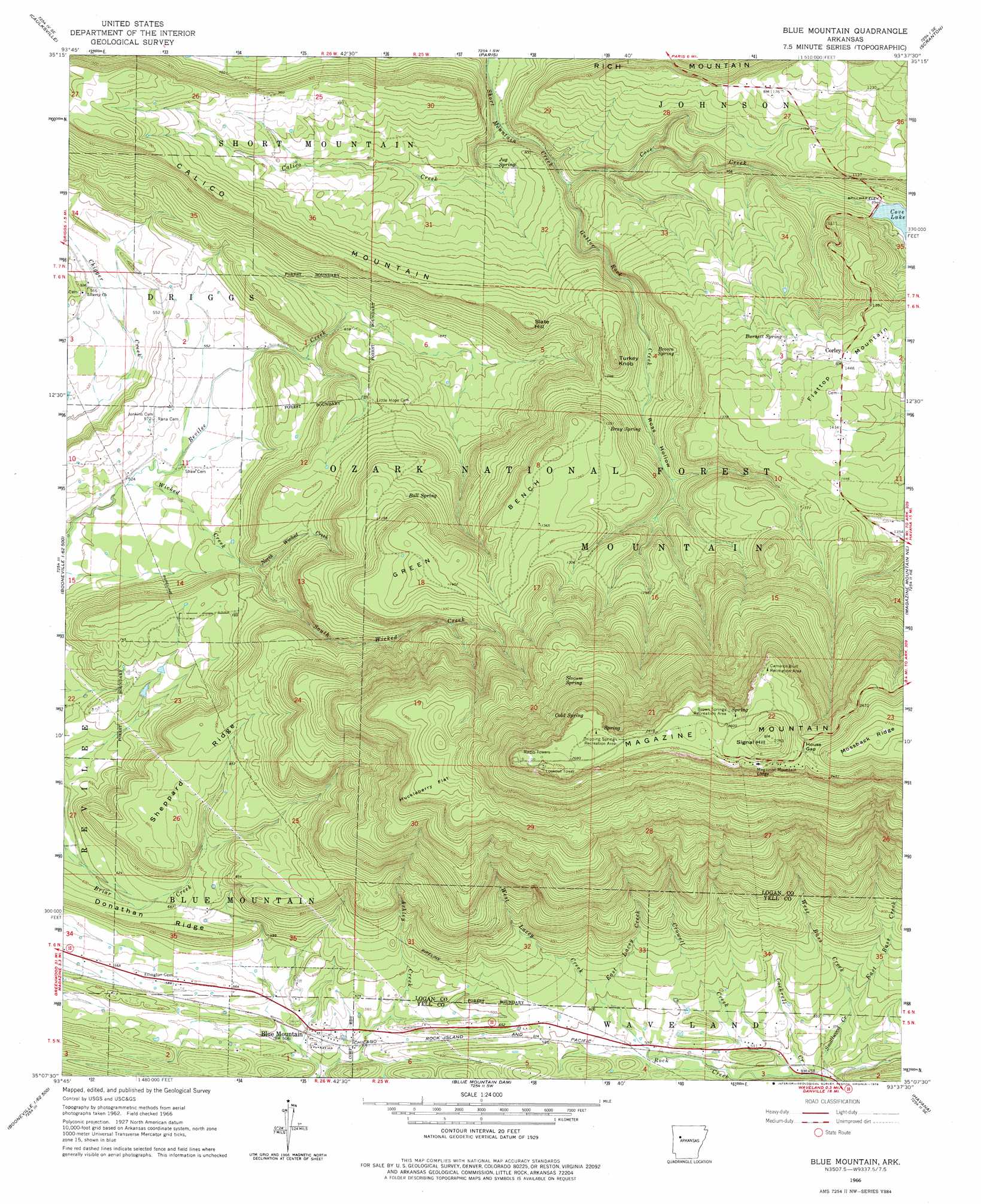
USGS Topo Quad 35093b6 - 1:24,000 scale
| Topo Map Name: | Blue Mountain |
| USGS Topo Quad ID: | 35093b6 |
| Print Size: | ca. 21 1/4" wide x 27" high |
| Southeast Coordinates: | 35.125° N latitude / 93.625° W longitude |
| Map Center Coordinates: | 35.1875° N latitude / 93.6875° W longitude |
| U.S. State: | AR |
| Filename: | o35093b6.jpg |
| Download Map JPG Image: | Blue Mountain topo map 1:24,000 scale |
| Map Type: | Topographic |
| Topo Series: | 7.5´ |
| Map Scale: | 1:24,000 |
| Source of Map Images: | United States Geological Survey (USGS) |
| Alternate Map Versions: |
Blue Mountain AR 1966, updated 1967 Download PDF Buy paper map Blue Mountain AR 1966, updated 1978 Download PDF Buy paper map Blue Mountain AR 2011 Download PDF Buy paper map Blue Mountain AR 2014 Download PDF Buy paper map |
| FStopo: | US Forest Service topo Blue Mountain is available: Download FStopo PDF Download FStopo TIF |
1:24,000 Topo Quads surrounding Blue Mountain
Cecil |
Ozark |
Coal Hill |
Hartman |
Clarksville |
Branch |
Caulksville |
Paris |
Scranton |
New Blaine |
Booneville |
Magazine |
Blue Mountain |
Magazine Mountain Ne |
Chickalah Mountain West |
Golden City |
Sugar Grove |
Blue Mountain Dam |
Havana |
Danville |
Bee Mountain |
Freedom Mountain |
Gravelly |
Bluffton |
Rover |
> Back to 35093a1 at 1:100,000 scale
> Back to 35092a1 at 1:250,000 scale
> Back to U.S. Topo Maps home
Blue Mountain topo map: Gazetteer
Blue Mountain: Benches
Green Bench elevation 349m 1145′Blue Mountain: Cliffs
Cameron Bluff elevation 770m 2526′Blue Mountain: Dams
Cove Lake Dam elevation 303m 994′Hope Lake Dam elevation 220m 721′
Blue Mountain: Flats
Huckleberry Flat elevation 581m 1906′Blue Mountain: Gaps
House Gap elevation 775m 2542′Blue Mountain: Parks
Brown Springs Recreation Area elevation 786m 2578′Cameron Bluff Recreation Area elevation 779m 2555′
Cove Lake Recreation Area elevation 310m 1017′
Dripping Springs Recreation Area elevation 801m 2627′
Blue Mountain: Populated Places
Blue Mountain elevation 157m 515′Corley elevation 439m 1440′
Blue Mountain: Post Offices
Mount Magazine Post Office (historical) elevation 789m 2588′Blue Mountain: Reservoirs
Hope Lake elevation 220m 721′Blue Mountain: Ridges
Donathan Ridge elevation 218m 715′Magazine Mountain elevation 837m 2746′
Mossback Ridge elevation 827m 2713′
Sheppard Ridge elevation 259m 849′
Blue Mountain: Springs
Ball Spring elevation 352m 1154′Bray Spring elevation 391m 1282′
Brown Spring elevation 336m 1102′
Burnett Spring elevation 410m 1345′
Cold Spring elevation 679m 2227′
Jug Spring elevation 231m 757′
Slocum Spring elevation 619m 2030′
Blue Mountain: Streams
Calico Creek elevation 197m 646′Cockrell Creek elevation 138m 452′
Cove Creek elevation 216m 708′
Crowell Creek elevation 142m 465′
East Bass Creek elevation 171m 561′
East Lacey Creek elevation 178m 583′
Gutter Rock Creek elevation 214m 702′
Lick Creek elevation 315m 1033′
North Wicked Creek elevation 211m 692′
Smallwood Creek elevation 136m 446′
South Wicked Creek elevation 210m 688′
West Bass Creek elevation 172m 564′
West Lacey Creek elevation 178m 583′
Wicked Creek elevation 154m 505′
Blue Mountain: Summits
Calico Mountain elevation 366m 1200′Magazine Mountain elevation 837m 2746′
Short Mountain elevation 306m 1003′
Signal Hill elevation 837m 2746′
Slate Hill elevation 347m 1138′
Turkey Knob elevation 337m 1105′
Blue Mountain: Trails
Magazine Hiking Trail elevation 376m 1233′Blue Mountain: Valleys
Ross Hollow elevation 290m 951′Blue Mountain digital topo map on disk
Buy this Blue Mountain topo map showing relief, roads, GPS coordinates and other geographical features, as a high-resolution digital map file on DVD: