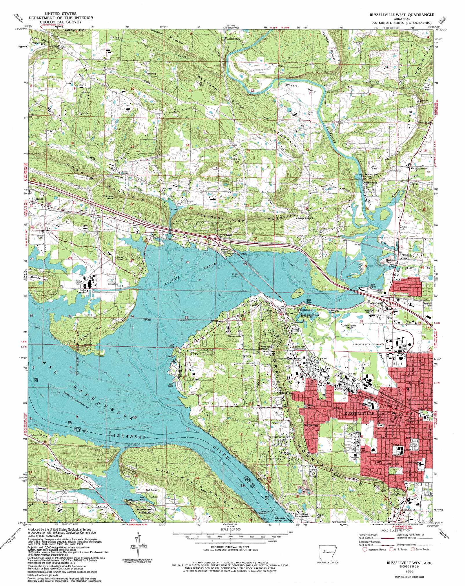
Russellville West Topo Map Arkansas
To zoom in, hover over the map of Russellville West
USGS Topo Quad 35093c2 - 1:24,000 scale
| Topo Map Name: | Russellville West |
| USGS Topo Quad ID: | 35093c2 |
| Print Size: | ca. 21 1/4" wide x 27" high |
| Southeast Coordinates: | 35.25° N latitude / 93.125° W longitude |
| Map Center Coordinates: | 35.3125° N latitude / 93.1875° W longitude |
| U.S. State: | AR |
| Filename: | o35093c2.jpg |
| Download Map JPG Image: | Russellville West topo map 1:24,000 scale |
| Map Type: | Topographic |
| Topo Series: | 7.5´ |
| Map Scale: | 1:24,000 |
| Source of Map Images: | United States Geological Survey (USGS) |
| Alternate Map Versions: |
Russellville West AR 1963, updated 1964 Download PDF Buy paper map Russellville West AR 1963, updated 1979 Download PDF Buy paper map Russellville West AR 1993, updated 1993 Download PDF Buy paper map Russellville West AR 2011 Download PDF Buy paper map Russellville West AR 2014 Download PDF Buy paper map |
1:24,000 Topo Quads surrounding Russellville West
Ludwig |
Hagerville |
Treat |
Simpson |
Solo |
Clarksville |
Knoxville |
Lee Mountain |
Dover |
Hector |
New Blaine |
Delaware |
Russellville West |
Russellville East |
Moreland |
Chickalah Mountain West |
Chickalah Mountain East |
Dardanelle |
Holla Bend |
Atkins |
Danville |
Danville Mountain |
Ola |
Casa |
Adona |
> Back to 35093a1 at 1:100,000 scale
> Back to 35092a1 at 1:250,000 scale
> Back to U.S. Topo Maps home
Russellville West topo map: Gazetteer
Russellville West: Airports
AMI Saint Marys Regional Medical Center Heliport elevation 109m 357′Ano Heliport elevation 114m 374′
Russellville West: Areas
Chactas Prairie elevation 103m 337′Russellville West: Bends
Wheeler Bend elevation 109m 357′Russellville West: Crossings
Interchange 78 elevation 117m 383′Interchange 81 elevation 110m 360′
Williamson Ford (historical) elevation 102m 334′
Russellville West: Dams
Lake Russellville Dam elevation 125m 410′Russellville West: Parks
Confederate Memorial Park elevation 168m 551′Dam Site Public Use Area elevation 104m 341′
Lake Dardanelle State Park elevation 113m 370′
Lake Dardanelle State Park elevation 109m 357′
Lake Dardanelle State Park - Ouita Area elevation 119m 390′
Shiloh Park elevation 106m 347′
Russellville West: Pillars
Chimney Rock elevation 182m 597′Russellville West: Populated Places
Baker Creek (historical) elevation 107m 351′Bernice elevation 105m 344′
Mill Creek elevation 105m 344′
Norristown elevation 167m 547′
Ouitaville elevation 111m 364′
Russellville elevation 103m 337′
Shiloh elevation 108m 354′
Russellville West: Post Offices
Russellville Post Office elevation 108m 354′Russellville West: Reservoirs
Lake Russellville elevation 125m 410′Russellville West: Streams
Bakers Creek elevation 101m 331′Cedar Creek elevation 105m 344′
Hayes Creek elevation 101m 331′
Huckleberry Creek elevation 105m 344′
Illinois Bayou elevation 105m 344′
Jones Creek elevation 101m 331′
Little Hayes Creek elevation 104m 341′
Mill Creek elevation 102m 334′
Prairie Creek elevation 104m 341′
Shiloh Creek elevation 108m 354′
Sulphur Creek elevation 107m 351′
Russellville West: Summits
Bunker Hill elevation 162m 531′Dardanelle Mountain elevation 210m 688′
East Point Mountain elevation 255m 836′
Linker Mountain elevation 232m 761′
Norristown Mountain elevation 217m 711′
Pleasant View Mountain elevation 206m 675′
Round Mountain elevation 141m 462′
Tucker Mountain elevation 230m 754′
Russellville West: Valleys
Hickerson Hollow elevation 100m 328′Russellville West digital topo map on disk
Buy this Russellville West topo map showing relief, roads, GPS coordinates and other geographical features, as a high-resolution digital map file on DVD: