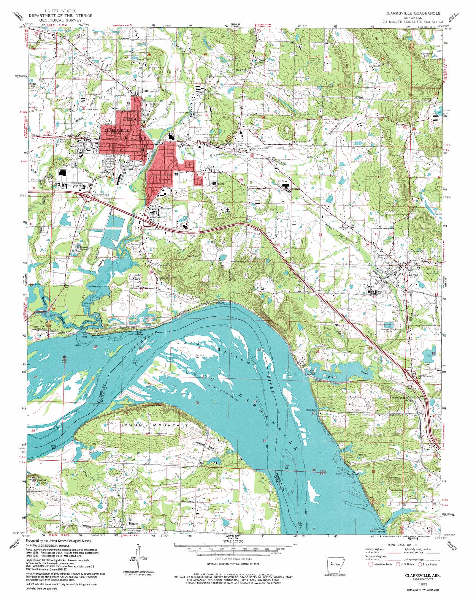
Clarksville Topo Map Arkansas
To zoom in, hover over the map of Clarksville
USGS Topo Quad 35093d4 - 1:24,000 scale
| Topo Map Name: | Clarksville |
| USGS Topo Quad ID: | 35093d4 |
| Print Size: | ca. 21 1/4" wide x 27" high |
| Southeast Coordinates: | 35.375° N latitude / 93.375° W longitude |
| Map Center Coordinates: | 35.4375° N latitude / 93.4375° W longitude |
| U.S. State: | AR |
| Filename: | o35093d4.jpg |
| Download Map JPG Image: | Clarksville topo map 1:24,000 scale |
| Map Type: | Topographic |
| Topo Series: | 7.5´ |
| Map Scale: | 1:24,000 |
| Source of Map Images: | United States Geological Survey (USGS) |
| Alternate Map Versions: |
Clarksville AR 1962, updated 1963 Download PDF Buy paper map Clarksville AR 1962, updated 1973 Download PDF Buy paper map Clarksville AR 1962, updated 1981 Download PDF Buy paper map Clarksville AR 1993, updated 1993 Download PDF Buy paper map Clarksville AR 2011 Download PDF Buy paper map Clarksville AR 2014 Download PDF Buy paper map |
1:24,000 Topo Quads surrounding Clarksville
Yale |
Oark |
Ozone |
Rosetta |
Fort Douglas |
Hunt |
Harmony |
Ludwig |
Hagerville |
Treat |
Coal Hill |
Hartman |
Clarksville |
Knoxville |
Lee Mountain |
Paris |
Scranton |
New Blaine |
Delaware |
Russellville West |
Blue Mountain |
Magazine Mountain Ne |
Chickalah Mountain West |
Chickalah Mountain East |
Dardanelle |
> Back to 35093a1 at 1:100,000 scale
> Back to 35092a1 at 1:250,000 scale
> Back to U.S. Topo Maps home
Clarksville topo map: Gazetteer
Clarksville: Airports
Clarksville Municipal Airport elevation 132m 433′Hospital Heliport elevation 137m 449′
Johnson County Regional Hospital Heliport elevation 158m 518′
Clarksville: Bends
Cuba Bottom elevation 103m 337′Clarksville: Crossings
Interchange 57 elevation 114m 374′Interchange 58 elevation 109m 357′
Interchange 64 elevation 113m 370′
Clarksville: Dams
Harris Pond Dam elevation 120m 393′Tritt Lake Dam elevation 103m 337′
Clarksville: Oilfields
Spadra Gas Field elevation 163m 534′Clarksville: Parks
Cabin Creek Public Use Area elevation 108m 354′Clarksville City Park elevation 134m 439′
Clarksville: Populated Places
Clarksville elevation 111m 364′Jamestown elevation 124m 406′
Knoxville Junction elevation 112m 367′
Lamar elevation 133m 436′
Spadra elevation 108m 354′
Tokalon elevation 133m 436′
Clarksville: Post Offices
Clarksville Post Office elevation 110m 360′Clarksville: Reservoirs
Harris Pond elevation 120m 393′Tritt Lake elevation 103m 337′
Clarksville: Streams
Craven Branch elevation 109m 357′Greenbrier Creek elevation 109m 357′
Little Spadra Creek elevation 101m 331′
Little Willett Branch elevation 105m 344′
Mud Branch elevation 100m 328′
Spadra Branch elevation 114m 374′
Spadra Creek elevation 101m 331′
Clarksville: Summits
Ragon Mountain elevation 176m 577′Clarksville digital topo map on disk
Buy this Clarksville topo map showing relief, roads, GPS coordinates and other geographical features, as a high-resolution digital map file on DVD: