Hagerville Topo Map Arkansas
To zoom in, hover over the map of Hagerville
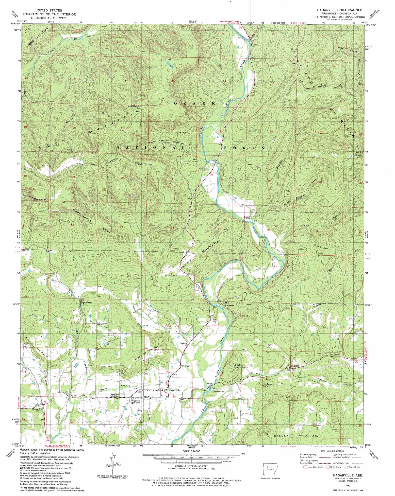
USGS Topo Quad 35093e3 - 1:24,000 scale
| Topo Map Name: | Hagerville |
| USGS Topo Quad ID: | 35093e3 |
| Print Size: | ca. 21 1/4" wide x 27" high |
| Southeast Coordinates: | 35.5° N latitude / 93.25° W longitude |
| Map Center Coordinates: | 35.5625° N latitude / 93.3125° W longitude |
| U.S. State: | AR |
| Filename: | o35093e3.jpg |
| Download Map JPG Image: | Hagerville topo map 1:24,000 scale |
| Map Type: | Topographic |
| Topo Series: | 7.5´ |
| Map Scale: | 1:24,000 |
| Source of Map Images: | United States Geological Survey (USGS) |
| Alternate Map Versions: |
Hagarville AR 1980, updated 1980 Download PDF Buy paper map Hagarville AR 2011 Download PDF Buy paper map Hagarville AR 2014 Download PDF Buy paper map |
| FStopo: | US Forest Service topo Hagarville is available: Download FStopo PDF Download FStopo TIF |
1:24,000 Topo Quads surrounding Hagerville
Boston |
Fallsville |
Swain |
Deer |
Lurton |
Oark |
Ozone |
Rosetta |
Fort Douglas |
Sand Gap |
Harmony |
Ludwig |
Hagerville |
Treat |
Simpson |
Hartman |
Clarksville |
Knoxville |
Lee Mountain |
Dover |
Scranton |
New Blaine |
Delaware |
Russellville West |
Russellville East |
> Back to 35093e1 at 1:100,000 scale
> Back to 35092a1 at 1:250,000 scale
> Back to U.S. Topo Maps home
Hagerville topo map: Gazetteer
Hagerville: Gaps
The Narrows elevation 176m 577′Hagerville: Populated Places
Hagarville elevation 162m 531′Poyner (historical) elevation 301m 987′
Strawberry elevation 196m 643′
Zadock (historical) elevation 435m 1427′
Hagerville: Post Offices
Hagarville Post Office elevation 164m 538′Hagerville: Ranges
Pine Mountain elevation 207m 679′Hagerville: Ridges
Chalybeate Spur elevation 455m 1492′Hagerville: Streams
Deevers Branch elevation 139m 456′Deevers Branch elevation 136m 446′
Dry Creek elevation 145m 475′
Granny Creek elevation 142m 465′
Grassy Point Creek elevation 277m 908′
Grassy Point Creek elevation 265m 869′
Little Granny Creek elevation 165m 541′
Little Minnow Creek elevation 126m 413′
Little Sulphur Creek elevation 224m 734′
Mikles Creek elevation 261m 856′
Peters Branch elevation 307m 1007′
Sulphur Creek elevation 187m 613′
Toms Branch elevation 180m 590′
Hagerville: Summits
Brown Mountain elevation 298m 977′Brown Mountain elevation 316m 1036′
Hagarville Mountain elevation 246m 807′
Hagerville Mountain elevation 228m 748′
Pilot Knob elevation 638m 2093′
Saul Mountain elevation 243m 797′
Tackey Hill elevation 337m 1105′
Tater Hill elevation 183m 600′
Tater Hill elevation 180m 590′
Turkey Hill elevation 373m 1223′
Woods Mountain elevation 658m 2158′
Hagerville: Valleys
Sally Ann Hollow elevation 195m 639′Sally Ann Hollow elevation 195m 639′
Hagerville digital topo map on disk
Buy this Hagerville topo map showing relief, roads, GPS coordinates and other geographical features, as a high-resolution digital map file on DVD: