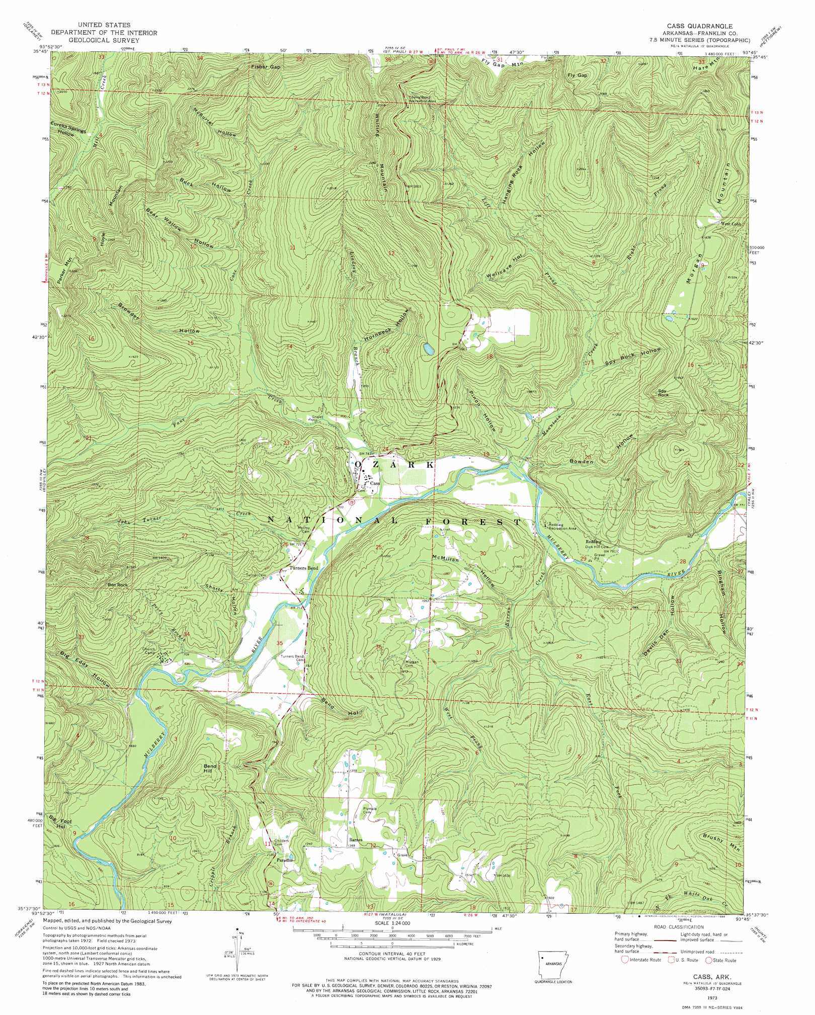
Cass Topo Map Arkansas
To zoom in, hover over the map of Cass
USGS Topo Quad 35093f7 - 1:24,000 scale
| Topo Map Name: | Cass |
| USGS Topo Quad ID: | 35093f7 |
| Print Size: | ca. 21 1/4" wide x 27" high |
| Southeast Coordinates: | 35.625° N latitude / 93.75° W longitude |
| Map Center Coordinates: | 35.6875° N latitude / 93.8125° W longitude |
| U.S. State: | AR |
| Filename: | o35093f7.jpg |
| Download Map JPG Image: | Cass topo map 1:24,000 scale |
| Map Type: | Topographic |
| Topo Series: | 7.5´ |
| Map Scale: | 1:24,000 |
| Source of Map Images: | United States Geological Survey (USGS) |
| Alternate Map Versions: |
Cass AR 1973, updated 1976 Download PDF Buy paper map Cass AR 1973, updated 1988 Download PDF Buy paper map Cass AR 2011 Download PDF Buy paper map Cass AR 2014 Download PDF Buy paper map |
| FStopo: | US Forest Service topo Cass is available: Download FStopo PDF Download FStopo TIF |
1:24,000 Topo Quads surrounding Cass
Sulphur City |
Durham |
Japton |
Witter |
Weathers |
Brentwood |
Delaney |
Saint Paul |
Pettigrew |
Boston |
Fern |
Bidville |
Cass |
Yale |
Oark |
Mountainburg Se |
Cravens |
Watalula |
Hunt |
Harmony |
Mulberry |
Cecil |
Ozark |
Coal Hill |
Hartman |
> Back to 35093e1 at 1:100,000 scale
> Back to 35092a1 at 1:250,000 scale
> Back to U.S. Topo Maps home
Cass topo map: Gazetteer
Cass: Gaps
Fisher Gap elevation 647m 2122′Fly Gap elevation 657m 2155′
Cass: Parks
Cherry Bend Recreation Area elevation 546m 1791′Redding Recreation Area elevation 225m 738′
Cass: Pillars
Bee Rock elevation 509m 1669′Spy Rock elevation 490m 1607′
Cass: Populated Places
Barnes elevation 417m 1368′Cass elevation 225m 738′
Fresno (historical) elevation 317m 1040′
Paradise elevation 345m 1131′
Redding elevation 241m 790′
West Cobb elevation 510m 1673′
Cass: Streams
Barron Creek elevation 224m 734′Big Foot Branch elevation 199m 652′
Cove Creek elevation 246m 807′
East Fork Barron Creek elevation 253m 830′
Fane Creek elevation 214m 702′
John Turner Creek elevation 207m 679′
Left Prong Mountain Creek elevation 259m 849′
Lindsey Branch elevation 222m 728′
Mountain Creek elevation 218m 715′
Perry Branch elevation 206m 675′
Right Prong Mountain Creek elevation 259m 849′
Rock Creek elevation 357m 1171′
West Prong Barron Creek elevation 253m 830′
Cass: Summits
Bend Hill elevation 413m 1354′Hoyle Mountain elevation 640m 2099′
Morgan Mountain elevation 569m 1866′
Parker Mountain elevation 686m 2250′
Whiting Mountain elevation 705m 2312′
Cass: Trails
Spy Rock Redding Loop elevation 430m 1410′Cass: Valleys
Bear Wallow Hollow elevation 312m 1023′Bend Hollow elevation 216m 708′
Big Eddy Hollow elevation 228m 748′
Big Foot Hollow elevation 192m 629′
Bingham Hollow elevation 234m 767′
Bowden Hollow elevation 241m 790′
Browder Hollow elevation 279m 915′
Buck Hollow elevation 310m 1017′
Devils Den Hollow elevation 248m 813′
Eureka Springs Hollow elevation 543m 1781′
Hanging Rock Hollow elevation 311m 1020′
Hornbeck Hollow elevation 275m 902′
McBurrel Hollow elevation 367m 1204′
McMillan Hollow elevation 244m 800′
Pinon Hollow elevation 223m 731′
Shorty Hollow elevation 215m 705′
Spy Rock Hollow elevation 259m 849′
Wellcave Hollow elevation 302m 990′
Cass digital topo map on disk
Buy this Cass topo map showing relief, roads, GPS coordinates and other geographical features, as a high-resolution digital map file on DVD: