Spiro Topo Map Oklahoma
To zoom in, hover over the map of Spiro
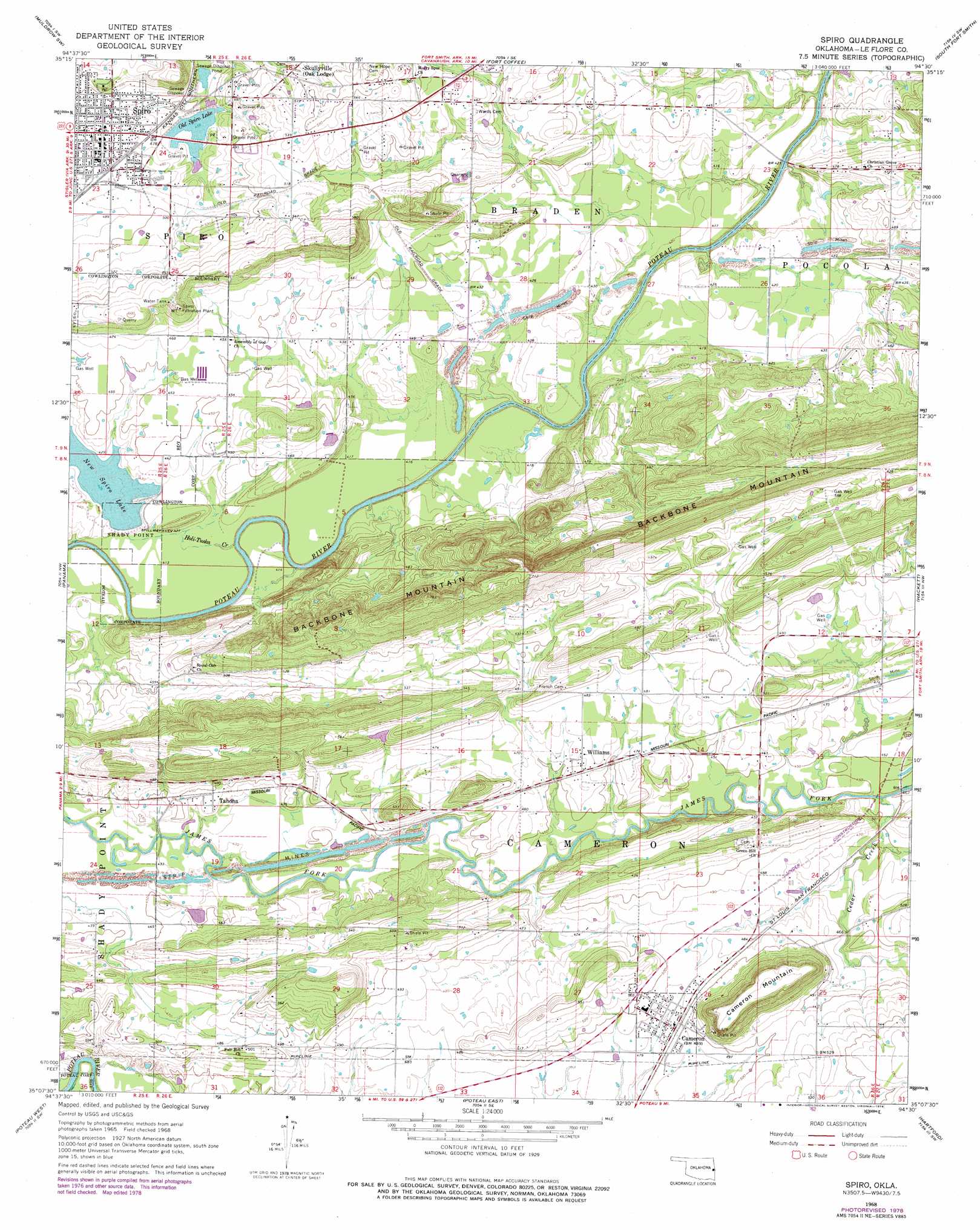
USGS Topo Quad 35094b5 - 1:24,000 scale
| Topo Map Name: | Spiro |
| USGS Topo Quad ID: | 35094b5 |
| Print Size: | ca. 21 1/4" wide x 27" high |
| Southeast Coordinates: | 35.125° N latitude / 94.5° W longitude |
| Map Center Coordinates: | 35.1875° N latitude / 94.5625° W longitude |
| U.S. State: | OK |
| Filename: | o35094b5.jpg |
| Download Map JPG Image: | Spiro topo map 1:24,000 scale |
| Map Type: | Topographic |
| Topo Series: | 7.5´ |
| Map Scale: | 1:24,000 |
| Source of Map Images: | United States Geological Survey (USGS) |
| Alternate Map Versions: |
Spiro OK 1968, updated 1969 Download PDF Buy paper map Spiro OK 1968, updated 1978 Download PDF Buy paper map Spiro OK 2010 Download PDF Buy paper map Spiro OK 2012 Download PDF Buy paper map Spiro OK 2016 Download PDF Buy paper map |
1:24,000 Topo Quads surrounding Spiro
Sallisaw |
Gans |
Muldrow |
Fort Smith |
Van Buren |
Robert S Kerr Dam |
Muldrow Sw |
Fort Coffee |
South Fort Smith |
Barling |
Bokoshe |
Panama |
Spiro |
Hackett |
Greenwood |
Potato Peaks |
Poteau West |
Poteau East |
Hartford |
Huntington |
Summerfield |
Wister |
Heavener |
Bates |
Cauthron |
> Back to 35094a1 at 1:100,000 scale
> Back to 35094a1 at 1:250,000 scale
> Back to U.S. Topo Maps home
Spiro topo map: Gazetteer
Spiro: Dams
New Spiro Lake Dam elevation 127m 416′Old Spiro Lake Dam elevation 140m 459′
Spiro: Populated Places
Cameron elevation 148m 485′Skullyville elevation 155m 508′
Spiro elevation 150m 492′
Tahona elevation 137m 449′
Williams elevation 141m 462′
Spiro: Reservoirs
New Spiro Lake elevation 127m 416′Old Spiro Lake elevation 140m 459′
Old Spiro Lake elevation 140m 459′
Spiro: Streams
Cedar Creek elevation 133m 436′Holi-Tuska Creek elevation 121m 396′
Spiro: Summits
Cameron Mountain elevation 209m 685′Spiro digital topo map on disk
Buy this Spiro topo map showing relief, roads, GPS coordinates and other geographical features, as a high-resolution digital map file on DVD: