Fern Topo Map Arkansas
To zoom in, hover over the map of Fern
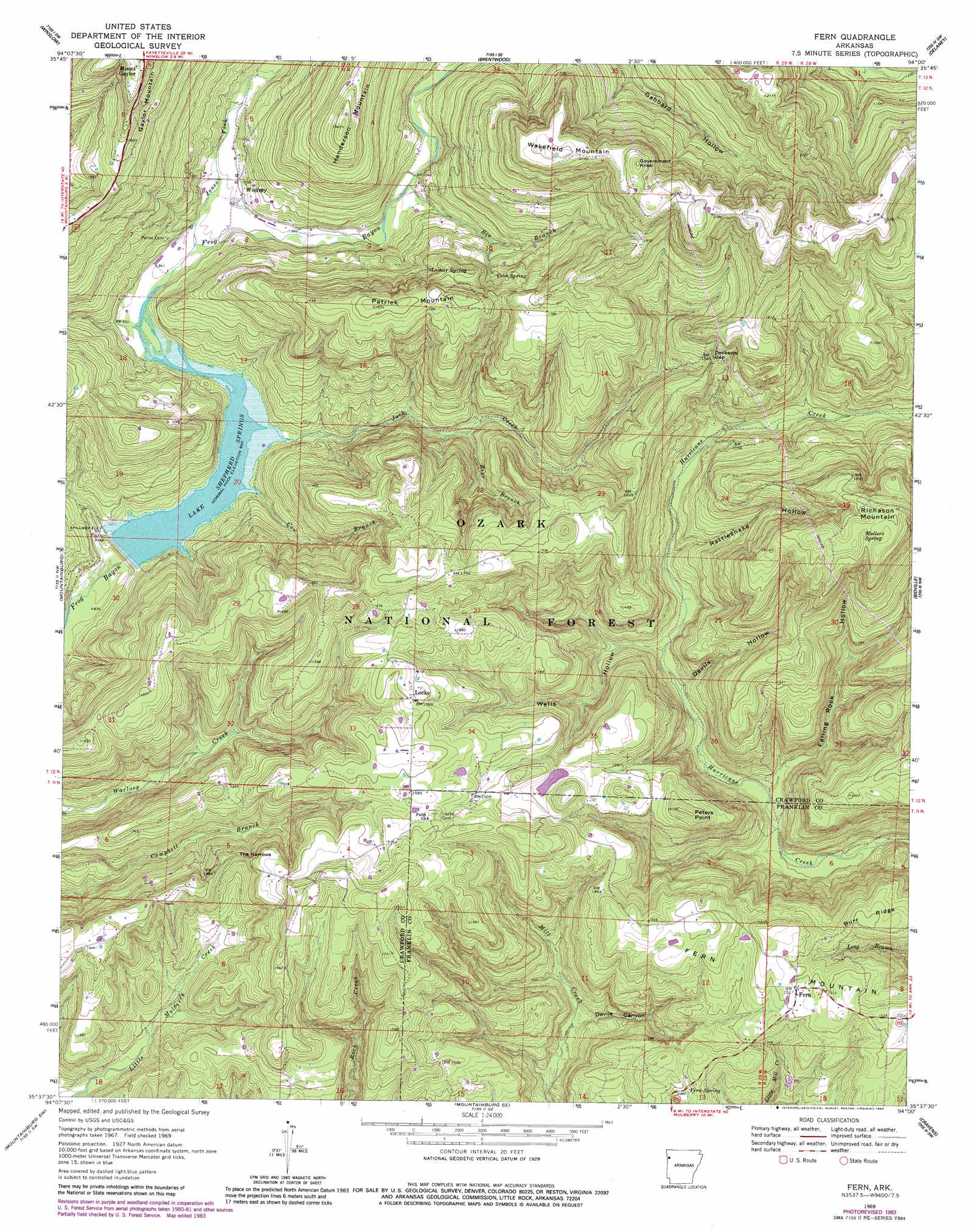
USGS Topo Quad 35094f1 - 1:24,000 scale
| Topo Map Name: | Fern |
| USGS Topo Quad ID: | 35094f1 |
| Print Size: | ca. 21 1/4" wide x 27" high |
| Southeast Coordinates: | 35.625° N latitude / 94° W longitude |
| Map Center Coordinates: | 35.6875° N latitude / 94.0625° W longitude |
| U.S. State: | AR |
| Filename: | o35094f1.jpg |
| Download Map JPG Image: | Fern topo map 1:24,000 scale |
| Map Type: | Topographic |
| Topo Series: | 7.5´ |
| Map Scale: | 1:24,000 |
| Source of Map Images: | United States Geological Survey (USGS) |
| Alternate Map Versions: |
Fern AR 1969, updated 1971 Download PDF Buy paper map Fern AR 1969, updated 1977 Download PDF Buy paper map Fern AR 1969, updated 1983 Download PDF Buy paper map Fern AR 2011 Download PDF Buy paper map Fern AR 2014 Download PDF Buy paper map |
| FStopo: | US Forest Service topo Fern is available: Download FStopo PDF Download FStopo TIF |
1:24,000 Topo Quads surrounding Fern
Prairie Grove |
West Fork |
Sulphur City |
Durham |
Japton |
Strickler |
Winslow |
Brentwood |
Delaney |
Saint Paul |
Rudy Ne |
Mountainburg |
Fern |
Bidville |
Cass |
Rudy |
Mountainburg Sw |
Mountainburg Se |
Cravens |
Watalula |
Van Buren |
Alma |
Mulberry |
Cecil |
Ozark |
> Back to 35094e1 at 1:100,000 scale
> Back to 35094a1 at 1:250,000 scale
> Back to U.S. Topo Maps home
Fern topo map: Gazetteer
Fern: Dams
Johnson Lake Dam elevation 441m 1446′Lake Sheppard Spring Dam elevation 267m 875′
Fern: Gaps
Dockerys Gap elevation 466m 1528′The Narrows elevation 430m 1410′
Fern: Populated Places
Fern elevation 458m 1502′Locke elevation 486m 1594′
Winfrey elevation 306m 1003′
Fern: Reservoirs
Johnson Lake elevation 441m 1446′Lake Shepherd Springs elevation 261m 856′
Lake Sheppard Spring Reservoir elevation 267m 875′
Fern: Springs
Cove Spring elevation 418m 1371′Fern Spring elevation 417m 1368′
Lamar Spring elevation 433m 1420′
Mullers Spring elevation 604m 1981′
Fern: Streams
Bear Branch elevation 336m 1102′Bee Branch elevation 310m 1017′
Cow Branch elevation 276m 905′
Jack Creek elevation 271m 889′
Jones Fork elevation 290m 951′
Fern: Summits
Fern Mountain elevation 468m 1535′Government Knob elevation 697m 2286′
Patrick Mountain elevation 553m 1814′
Peters Point elevation 479m 1571′
Richason Mountain elevation 602m 1975′
Wakefield Mountain elevation 679m 2227′
Fern: Valleys
Devils Canyon elevation 299m 980′Devils Hollow elevation 279m 915′
Falling Rock Hollow elevation 260m 853′
Rattlesnake Hollow elevation 309m 1013′
Wells Hollow elevation 277m 908′
Fern digital topo map on disk
Buy this Fern topo map showing relief, roads, GPS coordinates and other geographical features, as a high-resolution digital map file on DVD: