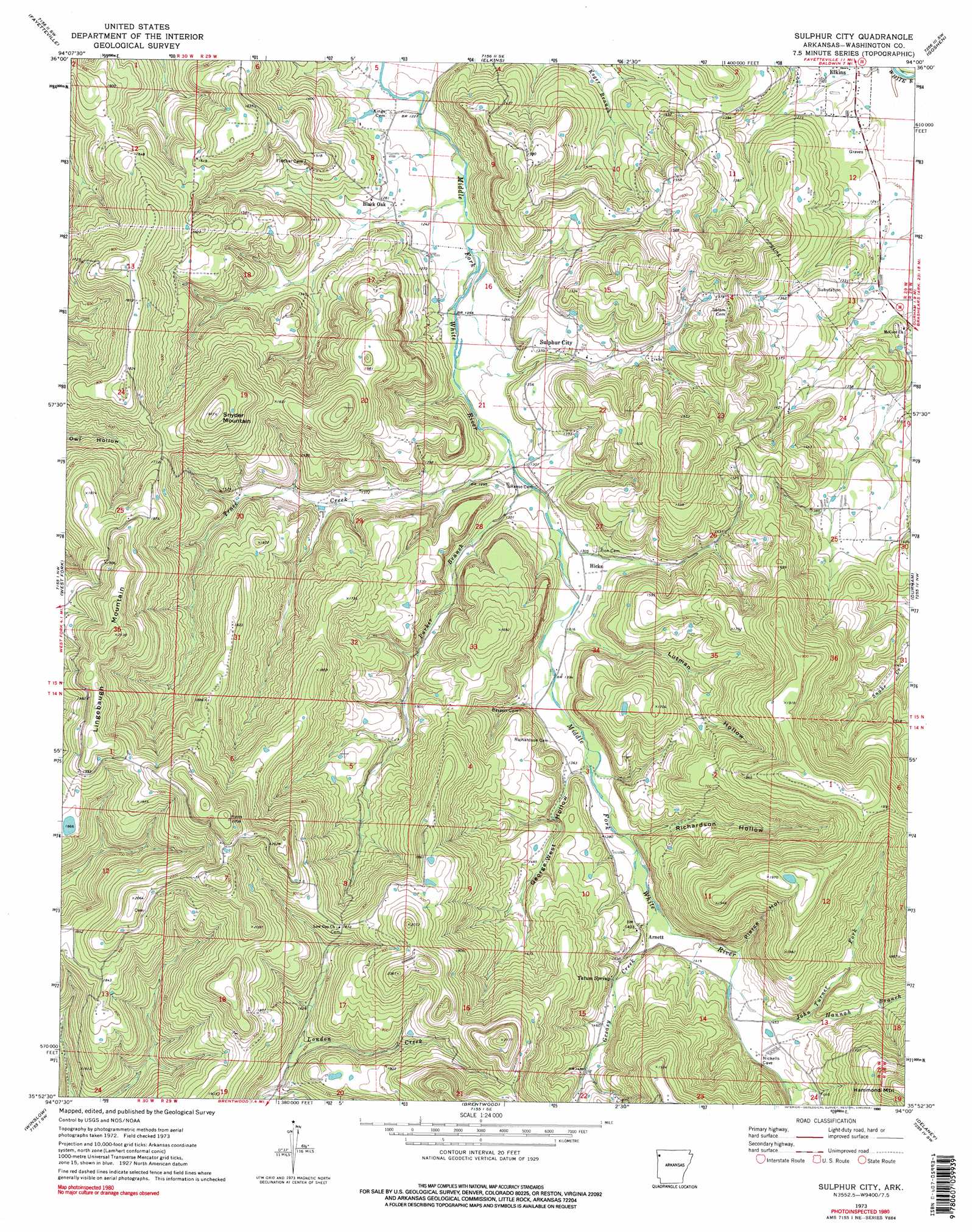
Sulphur City Topo Map Arkansas
To zoom in, hover over the map of Sulphur City
USGS Topo Quad 35094h1 - 1:24,000 scale
| Topo Map Name: | Sulphur City |
| USGS Topo Quad ID: | 35094h1 |
| Print Size: | ca. 21 1/4" wide x 27" high |
| Southeast Coordinates: | 35.875° N latitude / 94° W longitude |
| Map Center Coordinates: | 35.9375° N latitude / 94.0625° W longitude |
| U.S. State: | AR |
| Filename: | o35094h1.jpg |
| Download Map JPG Image: | Sulphur City topo map 1:24,000 scale |
| Map Type: | Topographic |
| Topo Series: | 7.5´ |
| Map Scale: | 1:24,000 |
| Source of Map Images: | United States Geological Survey (USGS) |
| Alternate Map Versions: |
Sulphur City AR 1973, updated 1976 Download PDF Buy paper map Sulphur City AR 1973, updated 1990 Download PDF Buy paper map Sulphur City AR 1973, updated 1990 Download PDF Buy paper map Sulphur City AR 2011 Download PDF Buy paper map Sulphur City AR 2014 Download PDF Buy paper map |
1:24,000 Topo Quads surrounding Sulphur City
Robinson |
Springdale |
Sonora |
Spring Valley |
Hindsville |
Wheeler |
Fayettville |
Elkins |
Goshen |
Hartwell |
Prairie Grove |
West Fork |
Sulphur City |
Durham |
Japton |
Strickler |
Winslow |
Brentwood |
Delaney |
Saint Paul |
Rudy Ne |
Mountainburg |
Fern |
Bidville |
Cass |
> Back to 35094e1 at 1:100,000 scale
> Back to 35094a1 at 1:250,000 scale
> Back to U.S. Topo Maps home
Sulphur City topo map: Gazetteer
Sulphur City: Dams
Heflin Lake Dam elevation 570m 1870′Sulphur City: Populated Places
Arnett elevation 444m 1456′Black Oak elevation 392m 1286′
Carter (historical) elevation 407m 1335′
Hicks elevation 400m 1312′
Sulphur City elevation 414m 1358′
Sulphur City: Post Offices
Arnett Post Office (historical) elevation 428m 1404′Carter Post Office (historical) elevation 407m 1335′
Hicks Post Office (historical) elevation 401m 1315′
Mount Salem Post Office (historical) elevation 482m 1581′
Sulphur City Post Office (historical) elevation 412m 1351′
Sulphur City: Reservoirs
Heflin Lake elevation 570m 1870′Sulphur City: Ridges
Parricks Ridge elevation 486m 1594′Sulphur City: Springs
Tatum Spring elevation 446m 1463′Sulphur City: Streams
Greasy Creek elevation 418m 1371′Hannah Branch elevation 440m 1443′
John Turner Fork elevation 427m 1400′
Parker Branch elevation 390m 1279′
Trace Creek elevation 388m 1272′
Sulphur City: Summits
Lingebaugh Mountain elevation 652m 2139′Snyder Mountain elevation 602m 1975′
Sulphur City: Valleys
George West Hollow elevation 416m 1364′Lutman Hollow elevation 412m 1351′
Pierce Hollow elevation 432m 1417′
Richardson Hollow elevation 530m 1738′
Sulphur City digital topo map on disk
Buy this Sulphur City topo map showing relief, roads, GPS coordinates and other geographical features, as a high-resolution digital map file on DVD: