Lincoln Topo Map Arkansas
To zoom in, hover over the map of Lincoln
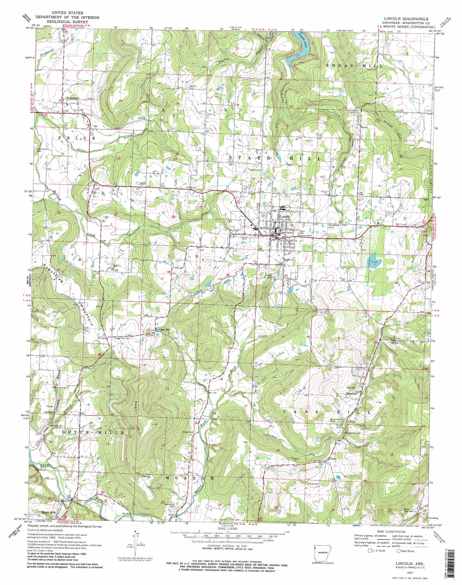
USGS Topo Quad 35094h4 - 1:24,000 scale
| Topo Map Name: | Lincoln |
| USGS Topo Quad ID: | 35094h4 |
| Print Size: | ca. 21 1/4" wide x 27" high |
| Southeast Coordinates: | 35.875° N latitude / 94.375° W longitude |
| Map Center Coordinates: | 35.9375° N latitude / 94.4375° W longitude |
| U.S. State: | AR |
| Filename: | o35094h4.jpg |
| Download Map JPG Image: | Lincoln topo map 1:24,000 scale |
| Map Type: | Topographic |
| Topo Series: | 7.5´ |
| Map Scale: | 1:24,000 |
| Source of Map Images: | United States Geological Survey (USGS) |
| Alternate Map Versions: |
Lincoln AR 1970, updated 1972 Download PDF Buy paper map Lincoln AR 1970, updated 1983 Download PDF Buy paper map Lincoln AR 1970, updated 1983 Download PDF Buy paper map Lincoln AR 2011 Download PDF Buy paper map Lincoln AR 2014 Download PDF Buy paper map |
1:24,000 Topo Quads surrounding Lincoln
Siloam Springs Nw |
Siloam Springs |
Gallatin |
Robinson |
Springdale |
Chance |
Watts |
Rhea |
Wheeler |
Fayettville |
Christie |
Westville |
Lincoln |
Prairie Grove |
West Fork |
Stilwell West |
Stilwell East |
Evansville |
Strickler |
Winslow |
Greasy |
Big Round Mountain |
Natural Dam |
Rudy Ne |
Mountainburg |
> Back to 35094e1 at 1:100,000 scale
> Back to 35094a1 at 1:250,000 scale
> Back to U.S. Topo Maps home
Lincoln topo map: Gazetteer
Lincoln: Dams
Cantrell Lake Dam elevation 424m 1391′Rodgers Lake Dam elevation 441m 1446′
Lincoln: Populated Places
Canehill elevation 402m 1318′Clyde elevation 403m 1322′
Dutch Mills elevation 313m 1026′
Lincoln elevation 449m 1473′
Summers elevation 362m 1187′
Suttle elevation 432m 1417′
Lincoln: Post Offices
Canehill Post Office elevation 402m 1318′Clyde Post Office (historical) elevation 405m 1328′
Summers Post Office elevation 358m 1174′
Lincoln: Reservoirs
Cantrell Lake elevation 424m 1391′Rodgers Lake elevation 441m 1446′
Lincoln: Springs
Cove Spring elevation 432m 1417′Salem Springs elevation 317m 1040′
Lincoln: Streams
Beatty Branch elevation 363m 1190′Bush Creek elevation 332m 1089′
Glendale Branch elevation 309m 1013′
Jordan Creek elevation 332m 1089′
Price Creek elevation 346m 1135′
Lincoln: Summits
Sugar Hill elevation 531m 1742′Sugartree Mountain elevation 434m 1423′
Lincoln digital topo map on disk
Buy this Lincoln topo map showing relief, roads, GPS coordinates and other geographical features, as a high-resolution digital map file on DVD: